The river and tributaries drain from the central mountains of Timor in a generally northeasterly direction into Ombai Strait. However, the river itself flows in a northwesterly direction, along the border between Bobonaro and Liquiçámunicipalities in Timor-Leste.
Course
The river is fed by a large number of gullies, creeks, streams and other rivers.[1]:12 Its headwaters are mainly in the portion of Timor's central mountains ranging between, on the one hand, Belu Regency, Indonesia, and Cova Lima municipality, Timor-Leste, both southwest of the river's mouth, and, on the other hand, Liquiçá municipality, Timor-Leste, to the mouth's east.[2][3][4][5][6]:26,44
From the southwestern headwaters, the river's southwestern and southern tributaries flow for the most part in a northeasterly direction through, or along the borders of, Belu Regency, Indonesia, and Bobonaro municipality, Timor-Leste (including borders with other municipalities), to the source of the river, at the confluence of the Nunura[de] and Marobo[de] rivers. That confluence is on the border between Bobonaro and Liquiçá municipalities, a short distance upstream of the tripoint between those two municipalities and Ermera municipality, Timor-Leste.[2][3][4][5][6]:26,44
At the river's source confluence and at the tripoint, the waters of its southwestern and southern tributaries converge with the waters from its southeastern and eastern tributaries. The river then flows, generally in a northwesterly direction, along the border between Bobonaro and Liquiçá, until it discharges into Ombai Strait, at the western end of the border between SucoRairobo[de], Atabae administrative post, Bobonaro, and SucoVatuboro[de], Maubara administrative post, Liquiçá.[3][5]
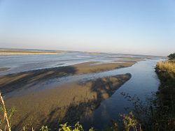
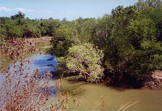
The river is one of the few perennial streams in the north of Timor-Leste,[7][8] one of only three such northern watercourses that can potentially be inhabited by saltwater crocodiles all year round (the others being the North Laclo and the Seiçal).[9] Its main channel, formed by the Marobo and Nunura Rivers, is braided, varies in width from about 200m (660ft) up to 1,400m (4,600ft), and is wider in its lower reaches.[1]:12
At the mouth of the river, Ombai Strait is part of the Banda Sea, which extends a little further west, to longitude 125° East; beyond that meridian, the strait is part of the Savu Sea.[10] A short distance upstream of the river mouth is the Loes Bridge, which was opened in 1991 and is the main bridge connecting West Timor, Indonesia, and Bobonaro with Dili, the national capital of Timor-Leste.[3][11]
In order of entrance, the river's main tributaries include the following:[2][3][4][5]
Merak River: rises in Fatumean administrative post in the far north west of Cova Lima municipality; flows northwest into, and then northwards through, Belu Regency, to enter the Talau River (see below) on the border between Belu Regency and SucoCová[de], Bobonaro municipality;[6]:26,44[12][13]
Talau River (or Taipui River): rises at Atambua, Belu Regency, near the westernmost point of the border between Belu Regency and Bobonaro municipality, flows southeast, and then northeast, forming the border between those two territories, until it merges with the Malibacu River (see below) to form the Nunutura River (see below);[14][15][16]
Malibacu River (or Malibaca River): rises in SucoTapo/Memo[de] in south central Bobonaro municipality; flows northwest to the border between that municipality and Belu Regency, and then further northwest, forming the border between those two territories, until it merges with the Talau River (see above) to form the Nunutura River (see below);[16][17]
Nunutura River (or Nunura or Bebai River): flows from the confluence of the Talau and Malibacu Rivers (see above) northeast through Bobonaro municipality to the border between Bobonaro and Liquiçá municipalities, very close to the tripoint between those two municipalities and Ermera municipality, where it merges with the Marobo River (see below) to form the Loes River;[18][19]
Bulobo River: rises near Maliana in south central Bobonaro; flows generally northwards until it enters the Nunutura River (see above) in central Bobonaro municipality;[20]
Marobo River: rises in Bobonaro municipality, near the southern point of the border between Bobonaro and Ermera municipalities; flows northwest, for the most part forming the border between those two municipalities, to the border between Bobonaro and Liquiçá municipalities a short distance southeast of the tripoint between those two municipalities and Ermera municipality, where it merges with the Nunutura River (see above) to form the Loes River;[14][21]
Gleno River (or Lauveli River): rises near Gleno in northeastern Ermera municipality, where it is fed in part by water draining from Lake Lehumo[de]; flows generally westwards, largely along the border between Ermera and Liquiçá municipalities, until it enters the Loes River at the tripoint between Bobonaro, Ermera and Liquiçá municipalities, a short distance northwest of the latter's source.[14][22][23][24]
History
For the period 1953 to 1979, which included the final years of the Portuguese colonial era in Timor-Leste, the colonial administration's Plans of Development (Portuguese: Planes de Fomento) identified the river as one of the locations targeted for the boosting of agricultural development. The III Plan of Development, for the years 1968 to 1973, placed particular importance on that objective.[14]:4
In 1979, during the Indonesian occupation of East Timor that had begun in 1975, the Indonesian army took over the Liquiçá area, and certain reconstruction work was commenced there.[14]:5
Two years later, Catholic Relief Services (CRS) and the United States Agency for International Development (USAID) established the East Timor Agricultural Development Project (ETDAEP), which was later transferred to Timorese control, under the name ETADEP Foundation. In the mid-1980s, some agricultural development work was started in the catchment, and cattle were distributed for use in ploughing muddy paddy fields. In about 1985, work began on the construction of an irrigation system. Some transmigration also took place, mostly from within the local area.[14]:5
At the beginning of this century, Timor-Leste resumed the independence it had declared in 1975, immediately before it was invaded by Indonesia. In 2015, the governments of Timor-Leste and Indonesia entered into a Memorandum of Understanding (MOU) on the Forestry Sector, as the first step of a commitment to manage shared natural resources jointly. One of the areas of cooperation for which the MOU provided was the management of cross-border catchments.[6]:27[25] In 2019, the two governments developed the Talau-Loes Management Plan Integrated Flow River Area or RPDAS.[6]:30 In 2020, the Global Environment Facility and the two governments initiated the Management of Indonesian and Timor-Leste Transboundary Watersheds (MITLTW) project, with the objective of ensuring "... collaborative management of freshwater ecosystems and protect[ing] water, food and livelihood security ..." in the catchment and another cross-border catchment.[6]:4
Catchment
The river combines with its tributaries to make up Timor-Leste's largest river system.[26]:34[27][1]:10 Its catchment or drainage basin has a total area of approximately 2,633km2 (1,017sqmi),[26]:33 including part of the province of East Nusa Tenggara in Indonesia.[27]
The East Timorese portion of the catchment is the largest of that country's catchments,[1]:10[28]:38[29]:24,28,31 but sources vary as to its size. Sources published before 2020 state that the East Timorese portion has a total area of 2,418km2 (934sqmi)[30]:9[note 1] (almost 15% of the whole country),[26]:34[27] and that about 9% of the catchment lies in Indonesia.[27] However, according to the official description of the MITLTW project, published in 2020, about 1,886.8km2 (728.5sqmi) (72%) of the catchment sits within Timor-Leste and approximately 726.48km2 (280.50sqmi) (28%) of it falls within Indonesia, where it is known as the Talau River catchment.[6]:23
Timor-Leste has been broadly divided into twelve 'hydrologic units', which are groupings of climatologically and physiographically similar and adjacent river catchments.[30]:2,52[31] The East Timorese portion of the Talau/Loes catchment is the only major catchment in the Loes hydrologic unit.[30]:9,52 Of the ten transboundary catchments in the Indonesia/Timor-Leste border area, the Talau/Loes catchment is the largest, and has the greatest water use and accessibility.[6]:22
The baseline scenario for the two catchments the subject of the MITLW project, including the Talau/Loes catchment, is characterised in the project documentation as: "continuation of poorly managed land uses, particularly agriculture, grazing and other activities degrading and removing forests/vegetation, which then contribute to soil degradation and loss, uncontrolled water flows, and associated deterioration in food and water security." The project aims to implement over a five-year period an alternative scenario achieving better protection of food, water and livelihood security within the two catchments.[6]:30,32
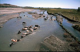
In Indonesia, the Talau/Loes catchment covers 10 districts and 61 villages in Belu Regency. In Timor-Leste, it ranges across 19 administrative posts and 120 sucos in six municipalities, namely Aileu, Ainaro, Bobonaro, Cova Lima, Ermera and Liquiçá. As of 2020[update], the catchment's population was around 191,000 in the Talau portion and 163,000 in the Loes portion, or about 354,000 in total. Its upstream sector is a water conservation area with a very small population. Its midstream is the most densely populated sector, and is used for transportation and water extraction. Its downstream links to and supplies water and sediment flows into Timor-Leste's mainland and coastal ecotone area.[6]:23,26[2]
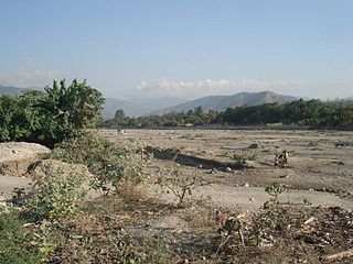
The catchment's elevation ranges from 1,500m (4,900ft)AMSL to sea level in the Talau portion, and from between 3,000m (9,800ft) and 2,000m (6,600ft) AMSL to sea level in the Loes portion. Its topography is dominated by slightly steep to steep slopes (according to the MITLTW project description, the area so dominated is 1,438.5km2 (555.4sqmi) or 55% of the catchment's total area).[6]:26 The dominant form of drainage system in the catchment is parallel pattern drainage.[1]:10
The catchment has a monsoon type climate, with a clear distinction between just two seasons, rainy and dry.[32]:S-4;3-1 The rainy season lasts about 6–7 months each year,[33]:18 and annual rainfall depends upon elevation and location.[6]:26 Over the catchment as a whole, average annual rainfall is around 1,600mm (63in), and is more than offset by high evaporation averaging 1,800mm (71in) per annum.[33]:18 In the upper reaches of the Talau River, it is between 1,500mm (59in) and 1,750mm (69in), and in the midstream of that river, it ranges from 1,250mm (49in) to 1,500mm (59in). In the upstream Loes River area, it can be more than 2,000mm (79in), in the midstream it is around 1,700mm (67in), and downstream it is between 1,200mm (47in) and 1,750mm (69in).[6]:26
According to a rapid appraisal of part of the Indonesian portion of the catchment published in 2008, the main hydrological concerns of the stakeholders in that area were sensitivity to climate variability, imbalance of water demand and supply in dry periods, and soil erosion that could cause further degradation to the landscape. The overall pattern of river flow was described as having three phases: the early part of the rainy season when the soil and landscape water storage capacity was recharged, the second part when a larger proportion of the rainfall was transmitted to the river, and the dry season when water flow depended on the gradual release of stored water. The report of the appraisal suggested catchment improvement activities such as water harvesting during the rainy season using semi-constructed ponds; soil management in the form of terracing and infiltration pits in tree-based systems, to avoid further soil degradation, and the planting of trees.[34]:ii,iii
Another rapid assessment, conducted in 2019, reported that there were several threats impacting the catchment. They included climate change and increasing variability in water availability; insufficient recharge areas; geomorphology that facilitated erosion, sedimentation and flooding; land use conflicts and over-exploitation of resources; and deforestation and land degradation. At the end of the 20th century, the total area of tree cover on the catchment's surface was more than 75%, but by 2019 it was down to only around 22%. Additionally, the catchment's low water availability baseline combined with poor soil and land management to result in low discharge and insufficient water reserves. Other hazard risks included biophysical vulnerability.[6]:28–29
Geology
The geological complexes and formations located underneath the catchment are the Aileu Formation, Bobonaro Complex, Viqueque Formation, Wailuli Formation, Cablac Limestone, Aitutu Formation and Lolotoi Complex. These lithodemic units are made up of sedimentary rocks, including shales, sandstone, siltstones, mudstones, calcilutite, calcarenite, calcirudites, marl, and conglomerates, and also some metamorphic rocks such as phyllites and other metamorphose sedimentary and eruptive rocks.[1]:10
The catchment's dominant parent rocks have been recorded as old, recent clastic, metamorphic, and uplifted coral limestones.[6]:26 The sediments and deposited fragments in the catchment include silt, upliftedcoral, phyllite, quartzites, schist, and alluvial and sandymarl (known as Bobonaro formation).[6]:26[33]:19 A mineral grain analysis of the sand from the river carried out in 2014 identified quartz, lithic fragment, feldspar, muscovite, pyroxene, magnetite, zircon, olivine, and garnet grains.[1]:10
Soil types in the catchment include vertisols, entisols, and inceptisols formed from the weathering sandstones, together with clay stones and uplifted coral limestones. These soil types can easily convert water into gravitational water, but will also hold the water so strongly as make it difficult for trees to absorb water by the roots.[6]:26[33]:19,20
Economy
Agriculture
About 90% of the catchment's residents carry on small scale agriculture, mostly the cultivation of subsistence crops, to earn their household income.[6]:26
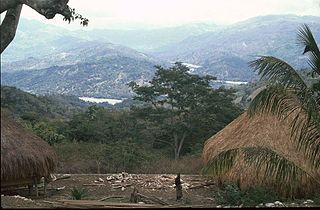
The main crops grown in the catchment are maize, upland and lowland rice, beans, tubers, fruits and vegetables.[6]:26 Those crops are not produced in quantities sufficient to meet the needs of the catchment's residents for food; water shortages are thought to be a significant factor in relation to that problem.[33]:17 Other catchment crops include cassava.[14]:3 Tree crops are also grown in the catchment; they include mangos, jackfruit, coconuts, cashew nuts, candle nuts, kapok, oranges, and betel nuts, all of which are cultivated extensively around water springs,[34]:16 and bananas.[14]:3 Additionally, catchment farmers raise livestock, including cattle, pigs, chickens, and goats;[6]:26[14]:3 these are often kept mainly for special occasions and important events.[14]:3,4
Shifting cultivation and unrestricted cattle grazing in the catchment lead to a reduction in forested areas, infertile soils, and low productivity/biomass. These outcomes lead to increased runoff and reduced infiltration, which, in turn, worsen the existing imbalances between rainfall and evaporation.[6]:28
A further crop grown in the catchment is coffee. The largest coffee plantation in the catchment is located in its upper reaches, and is owned by SAPT (Sociedade Agrícola Pátria e Trabalho).[29]:28
In the production of rice and other crops in the catchment, as elsewhere in Timor-Leste, both technical steps and ritual practices are considered necessary. One such ritual is nahe biti (lit.transl.stretching or laying down the mat to facilitate consensus, or reconciliation), by which the crop is subjected to ritual action that changes its status from moruk (transl.poisonous, bitter) to midar (transl.delicious, sweet).[14]:5,6
Nahe biti is performed during the harvesting of wet rice, to establish a communication channel with the river and thereby observe due reciprocity with it.[14]:8,9 The ritual normally begins with the placing of rice stalks and dishes of betel leaves and areca nuts on a mat and the recitation of prayers. Then comes the offering of glasses of wine and a pig, followed by the sacrifice and cooking of the pig with the other ingredients. Some of the stalks, tied into a cross-like form known as biko, are then each tied to a stick that is driven into the ground in the rice paddy until the harvest is finished.[14]:10–12
The harvesters perform the nahe biti ritual in the belief that the spirits of their ancestors and the river arrive in the rice paddy upon performance of the ritual, and stay there until the harvesters let them know the harvest has been completed. The harvesters make that communication by performing another ritual, sobu tenda, which involves the sacrifice of a chicken.[14]:12,13
Fishing
In Timor-Leste, involvement in fishing is low by comparison with other small island countries. Along the north coast of Timor, including near the mouth of the Loes River, fishing levels are higher than elsewhere in the country, other than in pockets along parts of the south coast. Many of the north coast fishers fish part time or seasonally, and are otherwise occupied in additional activities such as carpentry, labouring or security work. Most of their fish landings are of small pelagic species, including short-bodied mackerel, sardines (Clupeidae), halfbeaks and scads (Carangidae).[35]
In the coastal village of Biacou[de] (or Beacou), south of the Loes River mouth, most households earn their living from fishing or gleaning.[36]:9[37][38] During the rainy season, turbid water flows a long way out into the strait from the river mouth. Schools of fish gather at the river plume to feed and hide from larger fish, and sardines are at their most abundant. Using motorized canoes, Biacou fishers travel around 10km (6.2mi) to catch the sardines. After they are brought ashore, most are sold to traders. Some are cooked with locally grown garlic, red onion, and peppercorns, preserved in glass jars, and then sold at markets. Others are retained for local consumption. In the dry season, the river water becomes clear, and the fish disperse.[36]:9[39]
A study published in 2019 observed that fishing vessels in and around Bobonaro were dominated by non-motorized and outboard motorized boats. Gill nets and handlines were widely used. Fishing grounds were limited, and the activities of fishermen were highly disrupted by a growing number of illegal fishing practices. Small pelagic fish in the Indonesia – Timor-Leste border area in Ombai Strait were regarded as shared fish stock and captured by fishermen from both countries. The report of the study recommended transboundary fisheries management in the border area, using an ecosystem-based approach.[40]
A 2021 study focused in particular upon two fishing sites on the north coast of Timor-Leste, one of them being the fishery near the Loes River mouth. It concluded that a number of sardine species (and also other small pelagic fish) were caught in the Loes River mouth fishery, with flat-bodied sardinellas (S. gibbosa etc.) being the dominant species group landed there. Catches of the pelagic species varied moderately between years, and were larger during the rainy season and when medium-sized turbid plumes were extending from the river mouth. Fishers generally perceived a decline in landings over the previous 20 years. They attributed the decline to several human factors, including higher fishing effort, plastic pollution, motorisation of canoes and larger-scale, less selective fishing gear. Some sardine species were sold readily to traders; others were commonly kept for immediate home consumption.[35]
Along the river itself, fisherwomen capture freshwater shrimp, which they then hawk to passing road users on the Loes Bridge. In the past, shrimp were harvested with hand-woven nets, but the women now prefer to use traps made from plastic bottles. Some unsold shrimp become ingredients in boek kari (shrimp curry).[36]:19–20[41] Others are combined with mackerel or bullet tuna (Auxis rochei) and converted into fish powder. Local women also catch ipu, small indigenous fish, in the river, mix them with locally-made salt, and then pickle them in small bottles for up to a year.[42]
Hydroelectricity
The catchment has been assessed as having potential for the construction of a large scale multi-purpose dam to harvest raw water and generate hydroelectricity by hydropower.[43]
Mining
In November 2022, the Timor-Leste government, through its Council of Ministers, approved the opening of concession areas in three rivers, including the Loes River, for the mining of industrial minerals to be used in the production of construction materials.[44][45]
Also approved in November 2022 were tender terms for the award of mining rights in the concession areas.[44][45]
Each of the three rivers has abundant sediments transported from upstream in its catchment, or created by erosion of its banks. The sediments are deposited as either gravel or sand on the river's braided flood plains. After being deposited, the gravel and sand can be extracted and used primarily in the construction of small- to medium scale projects.[1]:9–12
The Loes River concession has a total estimated surface area of 834ha (2,060 acres). It is made up of two zones, one 500m (1,600ft) upstream of the Loes Bridge, and the other 500 m downstream of the bridge and 500 m away from the Ombai Strait shoreline.[1]:12
Bobonaro is a municipality in the Democratic Republic of Timor-Leste commonly known as East Timor. It is the second-most western municipality on the east half of the island. It has a population of 92,045 and an area of 1,376 km2.
Aileu is a municipality, and was formerly a district, of East Timor. It has a population of 48,554 and an area of 737 km2. The municipality's capital is also named Aileu. Its administrative posts are Aileu, Laulara, Lequidoe and Remexio.
Liquiçá is one of the municipalities of East Timor. Its capital is also called Liquiçá.
East Timor was a province of Indonesia between 1976 and 1999, during the Indonesian occupation of the country. Its territory corresponded to the previous Portuguese Timor and to the present-day independent country of East Timor.
Ermera is one of the municipalities of East Timor, located in the west-central part of the country. It has a population of 117,064 and an area of 756.5 km2.
Ainaro is one of 13 municipalities of East Timor, in the southwest part of the country. It has a population of 59,175 and an area of 804 km2. Its capital is the city of Ainaro, a small mountain town.
Ombai Strait is an international strait in Southeast Asia. It separates the Alor Archipelago from the islands of Wetar, Atauro, and Timor in the Lesser Sunda Islands. The strait is also the western portion of a pair of international straits, the other one being Wetar Strait; the two straits combine to link the Pacific Ocean with the Indian Ocean.
Wetar Strait is an international strait in Southeast Asia. It separates the island of Wetar from the eastern part of the island of Timor. The strait is also the eastern portion of a pair of international straits, the other one being Ombai Strait; the two straits combine to link the Indian Ocean with the Pacific Ocean.
The Seiçal River is a major river in northeastern East Timor. It flows for the most part in a northerly direction from headwaters in Timor's central mountains; after running past the eastern edge of the Baucau Plateau, it discharges into Wetar Strait.
The North Laclo River is the longest river in East Timor. It flows northeast into Wetar Strait, reaching the coast near the city of Manatuto. It has no connection to the South Laclo River, which flows into the Timor Sea.
The Caraulun River is a river in Timor-Leste. It flows for the most part in a southerly direction, forms the southern part of the border between Ainaro and Manufahi municipalities, and discharges into the Timor Sea.
The Sahen River is a river in East Timor. It originates in central Manatuto municipality, flows in a mostly southerly direction, and then discharges into the Timor Sea at the southern tip of the border between Manatuto and Manufahi municipalities.
The Comoro River is a river in Timor-Leste. It flows north into Ombai Strait, reaching the coast in the north western suburbs of the capital, Dili. In its lower reaches, it is the main and largest of Dili's four major rivers.
The Tono River is the principal river of Oecusse, an exclave of East Timor. The river and its major tributaries flow generally north, through the centre of the exclave, into the Savu Sea, reaching the sea near Lifau. Its alluvial flood plain in Pante Macassar administrative post is the main rice-producing place in Oecusse.
Timor-Leste has some of the best dive sites in the world due to its location, warm waters, minimalist tourist trade and lack of commercial fishing or heavy industry.
The Bandeira Waterfall is a tall waterfall in the municipality of Ermera, East Timor. It forms part of a minor tributary of the Loes River.
The South Laclo River is a river in the Manufahi municipality of Timor-Leste. It flows southwards, and then southeastwards, into the Timor Sea.
The Laleia River is a major river in northeastern Timor-Leste. It flows north from the country's central mountains into Wetar Strait.
References
Footnote
↑ Some sources, published more recently than 2006, mistranscribe this figure as either 2,148km2 (829sqmi) or 2,184km2 (843sqmi).
1 2 3 4 5 República Democrática de Timor-Leste: Bobonaro[Democratic Republic of Timor-Leste: Bobonaro](PDF) (Map). 1:75000 (in Portuguese). Cartography by Instituto Superior Técnico. Lisbon: Timor-Leste GIS Portal. Archived from the original(PDF) on 30 June 2007. Retrieved 18 July 2022.
1 2 3 República Democrática de Timor-Leste: Ermera[Democratic Republic of Timor-Leste: Ermera](PDF) (Map). 1:75000 (in Portuguese). Cartography by Instituto Superior Técnico. Lisbon: Timor-Leste GIS Portal. Archived from the original(PDF) on 30 June 2007. Retrieved 18 July 2022.
1 2 3 4 República Democrática de Timor-Leste: Liquiçá[Democratic Republic of Timor-Leste: Liquiçá](PDF) (Map). 1:75000 (in Portuguese). Cartography by Instituto Superior Técnico. Lisbon: Timor-Leste GIS Portal. Archived from the original(PDF) on 30 June 2007. Retrieved 18 July 2022.
↑ Sanchez, Hortencio (6 April 2021). "Ponte Loes besik atu kotu"[The Loes bridge is near to end]. Tatoli website (in Tetum). Tatoli. Retrieved 20 July 2022.
1 2 3 Timor-Leste: Cluster da Água[Timor-Leste: Water Cluster](PDF) (Report) (in Portuguese). Pontes e Parcerias nos Países de Língua Portuguesa. 2016. Retrieved 6 July 2022..
This page is based on this Wikipedia article Text is available under the CC BY-SA 4.0 license; additional terms may apply. Images, videos and audio are available under their respective licenses.