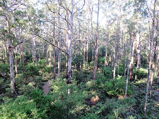
Gloucester National Park is a national park in Western Australia, 281 km south of Perth and about 3 km from Pemberton.

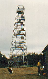
A fire lookout is a person assigned the duty to look for fire from atop a building known as a fire lookout tower. These towers are used in remote areas, normally on mountain tops with high elevation and a good view of the surrounding terrain, to spot smoke caused by a wildfire.

Poison Springs Battleground State Park is an Arkansas state park located southeast of Bluff City. It commemorates the Battle of Poison Spring in the American Civil War, which was part of the 1864 Camden Expedition, an element of a Union Army initiative to gain control of Shreveport, Louisiana and get a foothold in Texas.

A fire lookout tower, fire tower or lookout tower, provides housing and protection for a person known as a "fire lookout" whose duty it is to search for wildfires in the wilderness. The fire lookout tower is a small building, usually located on the summit of a mountain or other high vantage point, in order to maximize the viewing distance and range, known as view shed. From this vantage point the fire lookout can see smoke that may develop, determine the location by using a device known as an Osborne Fire Finder, and call fire suppression personnel to the fire. Lookouts also report weather changes and plot the location of lightning strikes during storms. The location of the strike is monitored for a period of days after in case of ignition.

Jenkins' Ferry Battleground State Park is the site of the American Civil War battle of Jenkins' Ferry, also known as the Engagement at Jenkins' Ferry, fought on Saturday, April 30, 1864, in present-day Grant County, Arkansas. The park was listed in the U.S. National Register of Historic Places on January 21, 1970, and, with seven other sites, is part of the Camden Expedition Sites National Historic Landmark, designated a National Historic Landmark District on April 19, 1994.
The Hunter Mountain Fire Tower is located on the summit of the eponymous mountain, second highest of the Catskill Mountains in the U.S. state of New York. It was the first of 23 fire lookout towers built by the state in the region, and the next-to-last of the five still standing to be abandoned.
Mitchell Recreation Area is a small picnic area located in the Fremont-Winema National Forests, Lake County, Oregon, near the unincorporated community of Bly. It is also known as Mitchell Monument. It is the only location in the United States where Americans were killed during World War II as a direct result of a Japanese balloon bomb. The site is maintained by the United States Forest Service and is listed on the National Register of Historic Places.

The Watchman Lookout Station No. 168 is one of two fire lookout towers in Crater Lake National Park in southern Oregon. For many years, National Park Service personnel used the lookout to watch for wildfires during the summer months. It is also a common hiking destination because of its views of Crater Lake and the surrounding area. The building is unusual because it serves the dual purpose of fire lookout and museum. The Watchman Lookout Station is listed on the National Register of Historic Places.
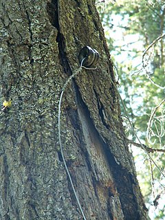
The Polebridge to Numa Ridge Phoneline is a historic communications path in Glacier National Park in the U.S. state of Montana. The line was the last remaining single-line crank telephone network in the American West. The remaining line, insulators, and terminals are instructive of early communication technology. The system includes the remains of a single strand system using an earth ground. Wire was strung through ceramic insulators mounted on trees. Phone poles still stand in the meadow south of Kishenehn Ranger Station, and a phone remains in place at Bowman Lake.
The Snowy Mountain Fire Observation Station is a 45 feet (14 m) steel-frame fire lookout tower on Snowy Mountain at Indian Lake in the Adirondack Mountains of New York.

The Unity Ranger Station is a United States Forest Service compound consisting of five buildings and a lookout tower in the Wallowa-Whitman National Forest of northeastern Oregon. It was previously the administrative headquarters for the Unity Ranger District. It is located in the small unincorporated community of Unity, Oregon. The historic structures were built in the rustic style by the Civilian Conservation Corps between 1936 and 1938. Today, the ranger station is only used during the summer months to house Forest Service fire crews. The ranger station is listed on the National Register of Historic Places.

The Hurricane Mountain Fire Observation Station is a historic fire observation station located on Hurricane Mountain at Keene in Essex County, New York. The station and contributing resources include a 35-foot-tall (10.7 m), steel frame lookout tower erected in 1919, two trails leading up the 3,694-foot (1,126 m) summit, and the ruins of a lean-to style observers cabin. The tower is a prefabricated structure built by the Aermotor Corporation to provide a front line of defense in preserving the Adirondack Park from the hazards of forest fires.

The Aermotor Windmill Company, or Aermotor Company, is an American manufacturer of wind-powered water pumps. The widespread use of their distinctive wind pumps on ranches throughout the arid plains and deserts of the United States has made their design a quintessential image of the American West.

The Sterling Mountain Fire Observation Tower and Observer's Cabin is a historic fire observation station located on Sterling Mountain in Sterling Forest State Park at Greenwood Lake in Orange County, New York. Located at an elevation of 1,320 ft (400 m), the station includes a 60-foot-tall (18 m), steel-frame lookout tower erected in 1922 and an observer's cabin built about 1934. The tower is a prefabricated structure built by the Aermotor Corporation and provided a front line of defense in preserving the Ramapo Mountains from the hazards of forest fires. The observer's cabin is of light frame construction, sheathed with board and batten siding stained brown.

A lookout tree is a simple fire lookout tower created by attaching a ladder or a series of spikes to a tall straight tree with a view of the surrounding lands, allowing rangers or fire crews to conveniently climb the tree to survey their surroundings. The simplest kind consist only of a ladder to a suitable height: this kind was called a "ladder tree." Some ladder trees had platforms on the ground next to them for maps and a fire finder. A more elaborate version often created a platform on top of the tree trunk by cutting off approximately the last 10 feet (3.0 m) of the treetop and building a railed wooden platform on the resulting stump. These "platform trees" were often equipped with telephones, fire finder tables, seats and guy wires. Accommodation for the watcher was provided by a tent or shelter at the bottom of the tree.
The lookout trees in Kaibab National Forest are the survivors of a system of improvised fire lookout towers that used tall, straight trees as vantage points. The practice of using trees as lookouts was widespread in the western United States during the early 20th century, as there was no need to build a foundation or to pack and assemble a tower structure. Instead, a prominent tree could be selected, and a ladder or a series of spikes could be attached to the tree trunk. For transient use this could be all that was done, but for more permanent use the top 10 feet (3.0 m) of the tree could be lopped, and a platform constructed on the resulting stump. This railed platform was then outfitted with a seat and a platform for an Osborne Fire Finder.
Coleman is an unincorporated community in Drew County, Arkansas, United States. Coleman is located at the junction of Arkansas Highway 83 and Arkansas Highway 277, 10.3 miles (16.6 km) north-northeast of Monticello. The Look See Tree, a lookout tree listed on the National Register of Historic Places, is located in Coleman.
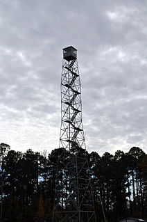
The Crossroads Fire Tower is a fire lookout tower at 2262 Arkansas Highway 133 North in Ashley County, Arkansas. The tallest tower of its type in Arkansas, it is located north of Crossett and west of Hamburg, which is just north of the junction of Highway 133 and Ashley County Highway 12. It was built by the Aermotor Company and installed by a Civilian Conservation Corps crew in 1935. When built it was 100 feet (30 m) tall, but an additional 20 feet (6.1 m) was added sometime between 1936 and 1943. The tower is of galvanized steel construction, although the staircase landings and treads are wooden. The tower has a viewing cabin at the top with adjustable glass panes.

The Los Burros Ranger Station is a forest ranger station situated in Apache County, Arizona. The station was manned by rangers who traveled to the nearby Lake Mountain Lookout.


