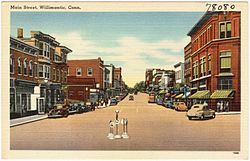
Willimantic is a census-designated place located in the town of Windham in Windham County, Connecticut, United States. It is a former city and borough, and is currently organized as one of two tax districts within the Town of Windham. Willimantic is part of the Southeastern Connecticut Planning Region. Known as "Thread City" for the American Thread Company's mills along the Willimantic River, it was a center of the textile industry in the 19th century. Originally incorporated as a city in 1893, it entered a period of decline after the Second World War, culminating in the mill's closure and the city's reabsorption into the town of Windham in the 1980s. Heroin use, present since the 1960s, became a major public health problem in the early 2000s, declining somewhat by the 2010s. Though the city was a major rail hub, an Interstate Highway has never passed within ten miles, despite early plans to connect it.

The Willimantic Footbridge is a pedestrian bridge in the Willimantic section of Windham, Connecticut. Built in 1906, it extends from Main Street southward, across Riverside Drive, railroad tracks, and the Willimantic River, connecting downtown Willimantic to the residential area south of the river. It is one of a small number of pedestrian bridges built in the early 20th century to survive in the state. It was listed on the National Register of Historic Places in 1979.

The Danielson Main Street Historic District encompasses the historic late 19th-century commercial business district of the borough of Danielson in the town of Killingly, Connecticut. It extends along Main Street, between the Five Mile River and Spring Street, including a few buildings on adjacent side streets, representing the area's growth as a commercial and civic center in the late 19th and early 20th centuries. It was listed on the National Register of Historic Places in 1992.
The Dayville Historic District encompasses a collection of mid-19th century architecture in the Dayville village of Killingly, Connecticut. It is clustered around the junction of Main and Pleasant streets, extending along Main to High Street. The area flourished in the mid-19th century, as a consequence of the railroad being routed nearby, serving area textile mills. The district, residential except for a church, was added to the National Register of Historic Places in 1988.

The Lawton Mills Historic District in Plainfield, Connecticut encompasses a well-preserved early-20th-century mill village. The central focus of the district is the large brick mill complex to the south of Railroad Avenue on the banks of Horse Brook. The mill ownership developed the areas on either side of the mill complex with a substantial worker housing complex. The district includes more than 100 historically significant structures, most of which are worker house that has survived with generally only modest alterations. There are a few commercial buildings in the district, built to provide services to the works, and a community hall, which now serves as Plainfield's town hall. The district was listed on the National Register of Historic Places in 1996.

Plainfield Street Historic District is a historic district in Plainfield, Connecticut that encompasses the historic area of Plainfield Village, the town center of Plainfield. The district is linear, being located along Route 12 between Railroad Avenue and Route 14A. It has been the center of the town's civic life since its settlement in the early 18th century, and includes two centuries of architectural styles. The district was listed on the National Register of Historic Places in 1991.

The Prospect Hill Historic District encompasses a large residential area in the Willimantic section of Windham, Connecticut. Located north of the Main Street commercial district, it was developed between about 1865 and 1930, and is one of the state's largest historic districts, with more than 800 contributing buildings. It is roughly bounded by Valley, Jackson, Bolivia, Washburn, Windham, and High Streets, and contains one of the state's largest single concentrations of Victorian-era residential architecture. It was listed on the National Register of Historic Places in 2003.
The South Coventry Historic District is a historic district encompassing the historic village center of South Coventry in the town of Coventry, Connecticut. The village, settled in the early 18th century, has served as Coventry's civic center, and also served as an economic center, with textile mills operating in the 19th century. The district was listed on the National Register of Historic Places in 1991.

The South Glastonbury Historic District is a historic district in Glastonbury, Connecticut. It encompasses the historic village center of South Glastonbury, which was first settled in the 17th century. The district was listed on the National Register of Historic Places in 1984, and enlarged in 2009 to include properties further along Main Street as far as Chestnut Hill Road. Locals refer to it as Nayaug.

The Central Village Historic District is a historic district in the Central Village area of Plainfield, Connecticut that was listed on the National Register of Historic Places (NRHP) in 1991. It encompasses a late 19th-century historic mill village, including a small commercial center where Connecticut Route 12 and 14 meet, a cluster of architecturally distinguished buildings built by mill owners and managers, and a collection of mill worker housing units. It includes the Plainfield Woolen Company Mill, which is separately listed, as well as archaeological remnants of other mill infrastructure. It also includes Plainfield's old town hall and high school. Other architecturally prominent buildings include the c. 1855 Italianate mansion of mill owner Arthur Fenner, and the 1845 Greek Revival Congregational Church.

The Monument Square–Eagle Street Historic District is a historic district encompassing the civic heart of North Adams, Massachusetts. When it was originally designated in 1972, the district encompassed Monument Square – west of the intersection of Main Street and Church Street, and the location of a Civil War memorial – and the area around it. This designation included the North Adams Public Library, the First Baptist Church and First Congregational Church, and a block of shops Eagle Street. In 1988, the district's boundaries were increased to be roughly bounded by Holden, Center and Union Streets, the East Middle School, Summer Street, and Main Street. This expansion extended the district westward along Summer Street to include the US Post Office building and St. John's Church, and eastward to include Colgrove Park, the middle school, and St. Francis Catholic Church. An additional block of commercial buildings was also added on the north side of West Main Street, extending just west of Holden Street.

The North High Street Historic District is a historic district encompassing part of the downtown area of Holyoke, Massachusetts. When first added to the National Register of Historic Places in 1986, the district encompassed North High Street, between Dwight and Lyman Streets. This part of High Street was built between 1850 and 1885, and is lined with masonry buildings in Italianate and Second Empire styles. In 1992 the district was extended southward, adding three blocks of High Street between Dwight and Essex Streets. This expansions encompasses the growth of Holyoke during the height of its commercial success, between 1880 and 1930; it also includes the separately-listed Holyoke City Hall. The district was extended a third time, in 2008, adding a complex of three buildings at Dwight and Maple Streets that now houses the Holyoke Health Center.

The William Jillson Stone House is a historic house museum at 561 Main Street inside Jillson Square Park, in the Willimantic section of Windham, Connecticut. Built in 1825–27, it is a rare local instance of a stone house, built by one of the area's early industrialists. It is now maintained by the Windham Historical Society, and was listed on the National Register of Historic Places in 1971.

The Willimantic Freight House and Office is a historic railroad freight facility on Bridge Street in the Willimantic section of Windham, Connecticut. Built in 1870, the freight office, a fine example of Second Empire architecture, is now the only surviving element of the city's 19th-century railroad buildings; the freight house has been demolished. The buildings were listed on the National Register of Historic Places in 1982 as an important reminder of the city's importance as a major railroad junction in eastern Connecticut.

The Waterville Village Historic District encompasses most of the history 19th and early 20th-century village center of Waterville, Vermont. The village grew from beginnings late in the 18th century to serve as a modest civic, commercial, and residential hub for the rural community. It was added to the National Register of Historic Places in 2007.
The Suncook Village Commercial–Civic Historic District encompasses the civic and commercial heart of Suncook, New Hampshire, a village on the Suncook River in Pembroke and Allenstown. The civic district is a 3-acre (1.2 ha) area on the Pembroke side of the river, adjacent to the Pembroke Mill, a site that had seen industrial use since the 18th century. The district includes 21 commercial buildings, 19 of which are historically significant. The district was listed on the National Register of Historic Places in 2005.

The Newmarket Industrial and Commercial Historic District encompasses the heart of a distinctive 19th century mill town, Newmarket, New Hampshire. Its mill complex is regionally distinctive for its extensive use of stone from an early date, and the town is relatively well-preserved due to a significant economic decline after the mills closed in 1920. The district was listed on the National Register of Historic Places in 1980. The Stone School, listed in 1978, is a contributing resource.

The Brattleboro Downtown Historic District encompasses most of the central business district of the town of Brattleboro, Vermont. Extending along Main Street between Whetstone Brook and a junction with Pultney Road and Linden and Walnut Streets, this area includes many of the town's prominent civic and institutional buildings. The area's development took place primarily in the 19th century, with surviving buildings from both the 18th and early 20th centuries. The district was listed on the National Register of Historic Places in 1983, and was enlarged in 2004 to include Plaza Park and the Holstein Building on the south side of Whetstone Brook.
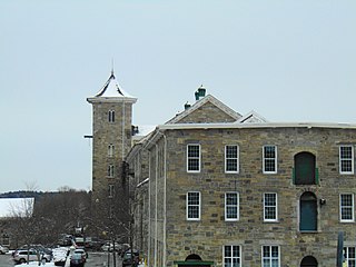
The Jillson Mills is a mill complex in Willimantic, Connecticut. The mills produced cotton thread throughout the lifespan of the operation of the mill.

The Windham Town Hall is a town hall in Willimantic, Windham, Connecticut, United States.