Willimantic is a census-designated place located in the town of Windham in Windham County, Connecticut, United States. It is a former city and borough, and is currently organized as one of two tax districts within the Town of Windham. Willimantic is part of the Southeastern Connecticut Planning Region. Known as "Thread City" for the American Thread Company's mills along the Willimantic River, it was a center of the textile industry in the 19th century. Originally incorporated as a city in 1893, it entered a period of decline after the Second World War, culminating in the mill's closure and the city's reabsorption into the town of Windham in the 1980s. Heroin use, present since the 1960s, became a major public health problem in the early 2000s, declining somewhat by the 2010s. Though the city was a major rail hub, an Interstate Highway has never passed within ten miles, despite early plans to connect it.

The Willimantic Footbridge is a pedestrian bridge in the Willimantic section of Windham, Connecticut. Built in 1906, it extends from Main Street southward, across Riverside Drive, railroad tracks, and the Willimantic River, connecting downtown Willimantic to the residential area south of the river. It is one of a small number of pedestrian bridges built in the early 20th century to survive in the state. It was listed on the National Register of Historic Places in 1979.

Northeastern Connecticut, better known as the Quiet Corner, is a historic region of the state of Connecticut, located in the northeastern corner of the state. It is generally associated with Windham County, but also sometimes incorporates eastern sections of Tolland County and the northern portion of New London County.

Wyoming is a village and census-designated place on the Wood River in southern Rhode Island, primarily in the town of Richmond, Rhode Island, but extending north across the river into the town of Hopkinton, Rhode Island. The population was 270 at the 2010 census. It is the site of the Wyoming Village Historic District and a post office assigned ZIP code 02898.

Broad Street – Davis Park Historic District is a historic district in the borough of Danielson, in the town of Killingly, Connecticut. The district is mainly residential in character, and includes Davis Park, a 1.9-acre (0.77 ha) triangular park created in 1890 and bounded by Main, Reynolds, and Broad Streets. The district as a whole is 30 acres (12 ha) in size. It includes examples of Stick/Eastlake, Queen Anne, and Colonial Revival architectural styles and was added to the National Register of Historic Places in 1998. It includes 95 contributing buildings, one contributing site, and four contributing objects.

Quinebaug Mill–Quebec Square Historic District is a historic district roughly bounded by the Quinebaug River, Quebec Square, and Elm and S. Main Streets in the town of Brooklyn in Windham County, Connecticut. The district encompasses a well-preserved 19th-century mill village. It was added to the National Register of Historic Places in 1985.

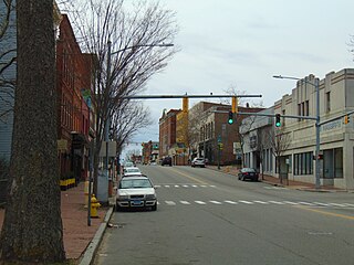
The Main Street Historic District encompasses the historic portion of the central business district of Willimantic, in Windham, Connecticut. The district encompasses the commercial business district of Willimantic and is roughly linear along Main Street and Riverside Drive between Church Street and Bridge Street. It was first listed on the National Register of Historic Places in 1982. Its area was increased in 1992 to include the Hall and Bill building on North Street, built in 1889 by one of Willimantic's leading printers.

The Branford Point Historic District is a historic district in Branford, Connecticut. It was listed on the National Register of Historic Places in 1988. It includes a significant portion of the Branford Point neighborhood, generally considered to be the area along the west side of the Branford Harbor to the Amtrak railroad tracks. It is bounded on the west by the Short Beach neighborhood, on the north by Branford Center, and on the east by the Branford River. Harbor Street, Maple Avenue, and Stannard Avenue are the main thoroughfares of the neighborhood. In the 2000 Census, Branford Point was included by the U.S. Census Bureau in the Branford Center census-designated place.

The Willimantic Elks Club is a historic Elks lodge at 198 Pleasant Street in the Willimantic section of Windham, Connecticut. Built in 1925 for a lodge founded in 1914, it is one of the finest examples of Tudor Revival architecture in the region, and has been a major site of social events in the community since. The building was added to the National Register of Historic Places in 2005.

The Main Street Historic District No. 2 is a historic district in Hartford, Connecticut. It encompasses a city block in the city's downtown noted for its concentration of insurance-related highrise commercial buildings constructed in the early decades of the 20th century. It is visually dominated by the Travelers Tower, completed in 1919 and for many years Hartford's tallest building. The district was listed on the National Register of Historic Places in 1984, at which time it included seven contributing buildings over a nine-acre area.

The Hillside Historic District in Waterbury, Connecticut is a 106-acre (43 ha) historic district that was listed on the National Register of Historic Places (NRHP) in 1987. It encompasses a residential area north of the city's central business district, and is bounded on the south by West Main Street, the west by Willow Avenue and Cliff and Frederick Streets, on the north by Buckingham Street and Woodland Terrace, and on the east by Cooke Street. Developed principally over an 80-year period between 1840 and 1920, it includes a cross-section of architectural styles of the 19th and early 20th centuries. The area was a desirable neighborhood of the city for much of this time, and was home to a number of the city's elite. In 1987, it included 395 buildings deemed to contribute to the historic character of the area, and one other contributing structure. It includes the Wilby High School and the Benedict-Miller House, which are both separately listed. 32 Hillside Road, a several acre property that includes the Benedict Miller House, was the original site of The University of Connecticut's Waterbury Branch until 2003.

The Bellows Falls Neighborhood Historic District encompasses a residential area of the village of Bellows Falls, Vermont. Located south of downtown Bellows Falls, the area has one of the largest concentrations of well-preserved 19th century residences in southern Vermont. It was listed on the National Register of Historic Places in 2002, and enlarged in 2007.

The Canal Street–Clark Street Neighborhood Historic District encompasses a compact 19th-century working-class neighborhood of Brattleboro, Vermont. Most of its buildings are modest vernacular wood-frame buildings, erected between 1830 and 1935; there are a few apartment blocks, and one church. The district was listed on the National Register of Historic Places in 1993.

The George–Pine–Henry Historic District encompasses a residential area of the village of Bellows Falls, Vermont. Located west of downtown Bellows Falls, the area has a significant concentration of well-preserved late 19th and early 20th-century residences. It was listed on the National Register of Historic Places in 2010.

The Depot Square Historic District encompasses the historic commercial business district of Randolph, Vermont. Developed in the mid-19th century around the facilities of the Central Vermont Railway, the area features a high concentration of well-preserved Second Empire and late Victorian commercial architecture. It was listed on the National Register of Historic Places in 1975.
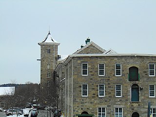
The Jillson Mills is a mill complex in Willimantic, Connecticut. The mills produced cotton thread throughout the lifespan of the operation of the mill.
The New Milford Center Historic District encompasses much of the traditional civic and commercial heart of New Milford, Connecticut.
The Buckingham Square District of Hartford, Connecticut encompasses a mixed residential and commercial neighborhood area just south of the city's downtown. It is centered around Buckingham Square, laid out in 1830 on the site of an early colonial-era church. The district includes a concentration of well-preserved Victorian architecture from the 1860s to 1890s. It was listed on the National Register of Historic Places in 1977, and slightly enlarged in 1982.

The Federal Hill Historic District encompasses a predominantly residential area of Bristol, Connecticut, known for its high-quality 19th and early 20th-century residential architecture. Centered around the Federal Hill Green, it developed as a fashionable residential area, and features a large number of fine Italianate and Victorian houses. It was listed on the National Register of Historic Places in 1986.

The West End North Historic District encompasses a neighborhood of late 19th and early 20th century residential architecture in western Hartford, Connecticut and eastern West Hartford, Connecticut. Roughly bounded by Prospect, Elizabeth, and Lorraine Streets and Farmington Avenue, the area includes a large number of Colonial Revival and Queen Anne houses, as well as numerous buildings in other period styles, with only a small number of losses. It was listed on the National Register of Historic Places in 1985.


