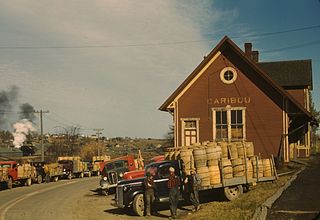
Caribou is the second largest city in Aroostook County, Maine, United States. Its population was 8,189 at the 2010 census. The city is a service center for the agricultural and tourism industries, and the location of a National Weather Service Forecast Office.

The Bangor and Aroostook Railroad was a United States railroad company that brought rail service to Aroostook County in northern Maine. Brightly painted BAR box cars attracted national attention in the 1950s. First-generation diesel locomotives operated on BAR until they were museum pieces. The economic downturn of the 1980s coupled with the departure of heavy industry from northern Maine forced the railroad to seek a buyer and end operations in 2003.
Caribou is one common name for the deer species Rangifer tarandus, also known as reindeer.
Channel X Radio is a network of adult contemporary/oldies/full-service formatted American radio stations in Aroostook County, Maine. With studios in Caribou the stations are heard through various transmitters throughout Aroostook County.

The Carrabassett River, a tributary of the Kennebec River, is located in Franklin County and Somerset County, Maine, in the United States. It rises near Sugarloaf Mountain, east of Rangeley Lake, and runs for 33.8 miles (54.4 km), flowing southeast past Kingfield and joining the Kennebec River in the town of Anson.

South Crocker Mountain is a mountain located in Franklin County, Maine. South Crocker Mountain is flanked to the north by Crocker Mountain, and to the southwest by Mount Redington.

Caribou Mountain is a mountain on the Canada–United States border, the section of which follows the height of land of the Saint Lawrence River watershed. The peak is located about 0.5 mi (0.80 km) inside Franklin County, Maine. The southwest end of Caribou's summit ridge is in Le Granit Regional County Municipality, Québec.
Caribou High School is a public high school educating students in grades 9 through 12. It is located in Caribou, Maine, at 308 Sweden Street in the United States.

WOZI is a classic rock formatted broadcast radio station licensed to Presque Isle, Maine, United States, serving the Presque Isle/Caribou/Houlton area. WOZI is owned and operated by Townsquare Media.

State Route 164 (SR 164) is part of Maine's system of numbered state highways. It runs 23.6 miles (38.0 km) from Presque Isle to Caribou. It begins at an intersection with U.S. Route 1 (US 1) just north of downtown Presque Isle and travels northwest along the Aroostook River to Crouseville and Washburn. In Washburn, it intersects SR 228. From there, it heads northeast to downtown Caribou. In Caribou, it splits into a one-way pair and also forms a concurrency with SR 161B. The southbound direction of travel through Caribou intersects SR 89 at its western terminus. After traveling through the center of the city, the road heads south along Main Street to end at US 1 south of the city center.

State Route 161 (SR 161) is part of Maine's system of numbered state highways. It runs 86 miles (138 km) from Fort Fairfield to Allagash. It begins at the Fort Fairfield - Andover Border Crossing along the Canada–US border to Dickey Road near the confluence of the Allagash and Saint John rivers.
The Little Madawaska River is a 42.6-mile-long (68.6 km) river in northern Maine. From its source in Maine Township 14, Range 5, WELS, it runs northeast and southeast to its confluence with the Aroostook River at Grimes Mill, about 3 miles (5 km) downstream from Caribou.
The South Branch Moose River is a tributary of the Moose River in Franklin County, Maine. Its source on Caribou Mountain is about 1.5 miles (2 km) from the Canada–United States border, in Skinner. From there, the river winds generally north for 11.0 miles (17.7 km) to its confluence with the main stream of the Moose River in Lowelltown.
The West Branch Moose River is a short tributary of the South Branch Moose River in Franklin County, Maine. Its source is on Caribou Mountain in Merrill Strip, about 2,000 feet (600 m) from the Canada–United States border, which runs along the height of land between the watersheds of the Kennebec River in Maine and the Chaudière River in Quebec. From there, the river runs 5.9 miles (9.5 km) northeast to its confluence with the Moose River's South Branch in Skinner.
Speckled Mountain is a mountain located in western Maine. It can be ascended by the Bickford Brook, Spruce Hill, Cold Brook, Red Rock and Blueberry Ridge trails, and is a popular day hike. It is a part of the Caribou-Speckled Mountain Wilderness within the White Mountain National Forest. It is located near the AMC Cold River Camp.

The National Weather Service Caribou, Maine is a local office of the National Weather Service responsible for monitoring weather conditions in northern Maine. It is co-located with an upper air sounding facility but the NEXRAD radar KCBW is near Houlton, Maine, further south.
Donald Frederick Collins was an American politician from Maine. Collins, a Republican from Caribou, Aroostook County, served 5 terms in the Maine Legislature between 1970 and 1992. He also served as mayor of Caribou.
Patricia M. Collins is an American civic leader and politician who served as the mayor of Caribou, Maine from 1981 to 1982. She has chaired numerous local and state boards and organizations, including the Caribou School Board, the Maine Committee for Judicial Responsibility and Disability, Catholic Charities Maine, and the University of Maine Board of Trustees. She was inducted into the Maine Women's Hall of Fame in 2005.
Millinocket Lake is the source of Millinocket Stream in the North Maine Woods north of Baxter State Park. Millinocket Stream flows 5.5 miles (8.9 km) to Maine township 8, range 8, where it joins Munsungan Stream to form the Aroostook River. The lake extending along the border of Maine range 9 townships 7 and 8 is impounded behind a wooden dam. The dam enlarged the lake to include Little Millinocket Lake and Moose Pond by flooding adjoining bogs to store water for hydropower. The large areas of shallow flooded bog are a good habitat for fallfish, yellow perch and white suckers; but with summer water temperatures ranging from 70° near the surface to 55° in the deeper areas, dissolved oxygen concentrations become unfavorable for trout. Tributaries to the lake drain a number of small ponds to the west of the lake including Atkins Pond, Blackmore Pond, Buckley Pond, Big Caribou Pond, Little Caribou Pond, Chandler Pond, Elsie Pond, Ervin Pond, Jack Pond, Kyle Pond, Line Pond, Mathews Pond, May Pond, Little Moose Pond, Upper Moose Pond, Pretty Pond, Snowshoe Pond, and Spring Pond.

Parmachenee Lake is on the Magalloway River near the Canadian border on the western edge of Maine. The lake was named for the daughter of Native American chief Metalluk, and is best known for the Gilded Age Parmachenee Club. The Magalloway River headwaters enter the north end of the lake in Parmachenee township, and the lake extends south into Lynchtown township where it overflows 2 miles (3.2 km) upstream of Aziscohos Reservoir.


