Mansfield is a town in Tolland County, Connecticut, United States. The town is part of the Capitol Planning Region. The population was 25,892 at the 2020 census.

The Cheney Brothers Historic District was a center of the silk industry in Manchester, Connecticut, in the late 19th and early 20th century. The 175-acre (71 ha) district includes over 275 mill buildings, workers houses, churches, schools and Cheney family mansions. These structures represent the well-preserved company town of the Cheney Brothers silk manufacturing company, the first America-based silk company to properly raise and process silkworms, and to develop the difficult techniques of spinning and weaving silk. The area was declared a National Historic Landmark in 1978.

The Town Brook Historic and Archeological District is a historic district encompassing much of the length of Town Brook and its surrounding landscape in Plymouth, Massachusetts. This area has an industrial history that extends to 1620, when the Pilgrims arrived on the Mayflower and established Plymouth Colony. It extends roughly from the crossing of Billington Street, to the mouth of the brook in Plymouth Harbor. The district was listed on the National Register of Historic Places in 1995.

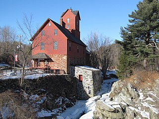
The Gurleyville Historic District encompasses a formerly industrial rural crossroads village in Mansfield, Connecticut. Centered on Gurleyville and Chaffeeville Roads, it includes a collection of mainly vernacular 19th-century residences, a stone gristmill dating to about 1749, and the archaeological remains of later industrial endeavours. The district was listed on the National Register of Historic Places in 1975.

The Talcottville Historic District is a historic district in the town of Vernon, Connecticut. Centered on Elm Hill Road and Main Street, it encompasses a 19th-century mill village, including archaeological remnants of very early cotton-spinning facilities, and old stone dam, and a major wood-frame mill constructed by the Talcott brothers. Also included in the village are a significant number of mill worker housing units, many dating to the middle decades of the 19th century, and an 1891 lenticular pony truss bridge, built by the Berlin Iron Bridge Company. The district was listed on the National Register of Historic Places in 1989.

The South Britain Historic District encompasses the core of the unincorporated village of South Britain in Southbury, Connecticut, United States. The village arose in the 18th century as an industrial center serving the surrounding agricultural community, powered by the Pomperaug River, and rivalled the town center of Southbury in importance. The district was listed on the National Register of Historic Places in 1987.

The West Whately Historic District is a historic district encompassing over 700 acres (280 ha) of western Whately, Massachusetts. The area, located in the foothills of The Berkshires above the Connecticut River, has a long agricultural history, but also experienced a surge of industrial activity in the 19th century, of which only fragments remain. The district, listed on the National Register of Historic Places in 2003, is focused on the areas surrounding West Brook and the areas where there was once industrial activity. From the late 18th century into the early 20th, there were some 16 mill complexes in the area, of which only one still has a surviving structure. The principal elements that survive of this industrial past are foundations and evidence of water works such as dams and millraces. There are only two institutional buildings in the district: the West Whately Chapel, built in the Queen Anne style in 1896, and a schoolhouse that has since been converted to a residence.

The Cushman Village Historic District is a historic district encompassing a portion of the Cushman Village area of Amherst, Massachusetts, which was a significant mill village during the 19th century. It is centered on the triangle formed by Bridge, Henry, and Pine Streets in northeastern Amherst, and arose because of the presence of falls on the Mill River, whose water power was harnessed for mills as early as the mid-18th century. Two houses survive from the colonial period. The village, although it was defined for many years by the mills, no longer has any industrial buildings, as they were demolished or destroyed by fire. Most of the houses in the district were built before 1860, the peak of the village's industrial activity. The district was listed on the National Register of Historic Places in 1992.

The Graniteville Historic District is a mainly residential historic district in Waterford, Connecticut. It is ranged along Rope Ferry Road, near granite quarries that were once a major industry in the town. Most of the 31 historical buildings in the district are plain residences occupied by quarry workers; also included are the c. 1878 Graniteville School at 239 Rope Ferry Road, and the house of John Palmer, one of the proprietors of the quarries, at 218 Rope Ferry Road. His house, a c. 1860 Italianate updating of an older house, is the most elaborate house in the district. The district was listed on the National Register of Historic Places in 2003.
The North Stonington Village Historic District is a 105-acre (42 ha) historic district encompassing the historic center of the main village of North Stonington, Connecticut. The district includes a well-preserved small industrial village, which flourished in the years before the American Civil War, and declined afterward. The district was listed on the National Register of Historic Places in 1983.
The Mansfield Center Historic District encompasses the historic early village center of Mansfield, Connecticut. First settled about 1692, it is one of the oldest settlements in Tolland County, and retains a strong sense of 18th century colonial layout. It extends along Storrs Street extending from Chaffeeville Road in the north to Centre Street in the south, and was listed on the National Register of Historic Places in 1972.

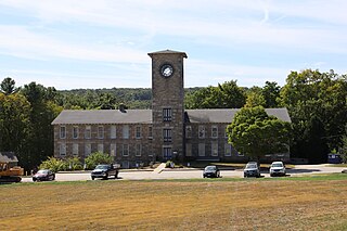
The University of Connecticut Historic District is a 105-acre (42 ha) historic district including the historic campus of the Connecticut Agricultural School, now the University of Connecticut (UConn).

Mansfield Center Cemetery is a small cemetery in the Mansfield Center section of Mansfield, Connecticut. Established in 1693, it is one of the few surviving elements of Mansfield's early colonial settlement history. It also has a distinguished array of funerary markers carved by acknowledged masters across eastern Connecticut. It was listed on the National Register of Historic Places in 1992.

The Spring Hill Historic District encompasses a rural 19th-century village stretching along Storrs Road in Mansfield, Connecticut. Spring Hill developed as a rural waystation on an early 19th-century turnpike, and has seen only modest development since the late 19th century. The district was listed on the National Register of Historic Places in 1979.
Edwin Fitch was an architect and builder in Connecticut.

Little York is an unincorporated community located along the border of Alexandria and Holland townships in Hunterdon County, in the U.S. state of New Jersey. Little York is located on County Route 614 3.1 miles (5.0 km) north-northeast of Milford. Little York has a post office with ZIP Code 08834.
Gillette's Grist Mill is a historic grist mill on Maple Hollow Road in New Hartford, Connecticut. Probably built in the mid-19th century, it is an extremely rare example of a grist mill with a surviving water wheel. The mill property was added to the National Register of Historic Places in 1977.

The Frog Hollow Stone Mill, or as it is now referred to, TheStone Mill, is a historic industrial building at 3 Mill Street in Middlebury, Vermont. Built in 1840, it is an important local reminder of the town's industrial past, and was listed on the National Register of Historic Places in 1973. It presently houses a restaurant, a public market, event space and four hotel rooms as part of an extensive renovation conducted in 2019.
The Jericho Village Historic District encompasses the historic industrial and commercial center of the village of Jericho, Vermont. Stretched along Vermont Route 15 south of Browns River, which powered the village's industries for many years, the village center includes a well-preserved array of 19th and early 20th-century buildings. The district was listed on the National Register of Historic Places in 1992.


