Manzanola, Colorado | |
---|---|
Coordinates: 38°6′33″N103°52′4″W / 38.10917°N 103.86778°W | |
Country | United States |
State | Colorado |
County [1] | Otero |
Incorporated (town) | July 9, 1900 [2] |
Government | |
• Type | Statutory Town [1] |
Area | |
• Total | 0.28 sq mi (0.74 km2) |
• Land | 0.28 sq mi (0.74 km2) |
• Water | 0.00 sq mi (0.00 km2) |
Elevation | 4,255 ft (1,297 m) |
Population | |
• Total | 341 |
• Density | 1,200/sq mi (460/km2) |
Time zone | UTC-7 (Mountain (MST)) |
• Summer (DST) | UTC-6 (MDT) |
ZIP code [6] | 81050 |
Area code | 719 |
FIPS code | 08-48500 |
GNIS feature ID | 0204826 |
Website | www |
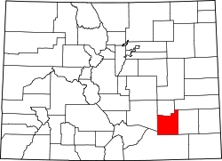
Manzanola is a Statutory Town in Otero County, Colorado, United States. The town population was 341 at the 2020 United States Census. [5]
A post office called Manzanola has been in operation since 1895. [7] The town was named for an orchard near the original town site, Manzanola being a name derived from Spanish meaning "red apple". [8]
Manzanola was previously known as Town of Grams Ranch, Town of Apishipa, and the Town of Catlin, in consecutive order. [9]
Manzanola is located at 38°6′33″N103°52′4″W / 38.10917°N 103.86778°W (38.109096, -103.867739). [10]
According to the United States Census Bureau, the town has a total area of 0.3 square miles (0.78 km2), all of it land.
Census | Pop. | Note | %± |
---|---|---|---|
1910 | 428 | — | |
1920 | 562 | 31.3% | |
1930 | 578 | 2.8% | |
1940 | 531 | −8.1% | |
1950 | 543 | 2.3% | |
1960 | 562 | 3.5% | |
1970 | 451 | −19.8% | |
1980 | 459 | 1.8% | |
1990 | 437 | −4.8% | |
2000 | 525 | 20.1% | |
2010 | 434 | −17.3% | |
2020 | 341 | −21.4% | |
U.S. Decennial Census |
As of the census [11] of 2000, there were 525 people, 189 households, and 120 families residing in the town. The population density was 2,018.2 inhabitants per square mile (779.2/km2). There were 209 housing units at an average density of 803.4 per square mile (310.2/km2). The racial makeup of the town was 74.48% White, 0.57% African American, 1.14% Native American, 0.57% Asian, 20.76% from other races, and 2.48% from two or more races. Hispanic or Latino of any race were 45.14% of the population.
There were 189 households, out of which 30.2% had children under the age of 18 living with them, 45.0% were married couples living together, 12.7% had a female householder with no husband present, and 36.5% were non-families. 31.2% of all households were made up of individuals, and 16.9% had someone living alone who was 65 years of age or older. The average household size was 2.74 and the average family size was 3.57.
In the town, the population was spread out, with 30.7% under the age of 18, 11.6% from 18 to 24, 24.0% from 25 to 44, 18.9% from 45 to 64, and 14.9% who were 65 years of age or older. The median age was 33 years. For every 100 females, there were 89.5 males. For every 100 females age 18 and over, there were 88.6 males.
The median income for a household in the town was $19,196, and the median income for a family was $26,250. Males had a median income of $24,688 versus $15,250 for females. The per capita income for the town was $9,598. About 23.2% of families and 30.3% of the population were below the poverty line, including 45.4% of those under age 18 and 15.8% of those age 65 or over.
Manzanola is part of Colorado's Bustang network. Is it along the Lamar-Pueblo-Colorado Springs Outrider line. [12]
Otero County is a county located in the U.S. state of Colorado. As of the 2020 census, the population was 18,690. The county seat is La Junta. The county was named for Miguel Antonio Otero, one of the founders of the town of La Junta and a member of a prominent Hispanic family.
Bent County is a county located in the U.S. state of Colorado. As of the 2020 census, the population was 5,650. The county seat and only incorporated municipality is Las Animas. The county is named in honor of frontier trader William Bent.
Las Animas is the statutory city that is the county seat, the most populous community, and the only incorporated municipality in Bent County, Colorado, United States. The city population was 2,300 at the 2020 United States Census. Las Animas is located on the Arkansas River, just west of its confluence with the Purgatoire River, in southeast Colorado east of Pueblo, near the historic Bent's Fort.
Buena Vista is a Statutory Town located in Chaffee County, Colorado, United States. The town population was 2,855 at the 2020 United States Census.
The City of Fountain is a home rule municipality located in El Paso County, Colorado, United States. The population was 29,802 at the 2020 census. Fountain is a part of the Colorado Springs, CO Metropolitan Statistical Area and the Front Range Urban Corridor.
Penrose is a census-designated place (CDP) and post office located in and governed by Fremont County, Colorado, United States. The CDP is a part of the Cañon City, CO Micropolitan Statistical Area. The Penrose post office has the ZIP Code 81240. At the United States Census 2020, the population of the Penrose CDP was 3,685.
Haswell is a Statutory Town located in Kiowa County, Colorado, United States. The town population was 71 at the 2020 United States Census.
Aguilar is a Statutory Town located in Las Animas County, Colorado, United States. The town population was 456 at the 2020 United States Census. Cattleman and prominent pioneer José Ramón Aguilar founded the town in 1894.
Dolores is a Statutory Town located in Montezuma County, Colorado, United States. The town population was 885 at the 2020 United States Census.
The Town of Hillrose is a statutory town located in Morgan County, Colorado, United States. The town population was 312 at the 2020 United States Census, an 18.18% increase since the 2010 United States Census.
Log Lane Village is a statutory town in Morgan County, Colorado, United States. The population was 913 at the 2020 census.
Wiggins is a statutory town in Morgan County, Colorado, United States. The population was 1,401 as of the 2020 census, up from 893 at the 2010 census.
Cheraw is a Statutory Town located in Otero County, Colorado, United States. The town population was 237 at the 2020 United States Census.
Fowler is a statutory town located in northwestern Otero County, Colorado, United States. The town population was 1,253 at the 2020 United States Census.
La Junta is a home rule municipality in, the county seat of, and the most populous municipality of Otero County, Colorado, United States. The city population was 7,322 at the 2020 United States Census. La Junta is located on the Arkansas River in southeastern Colorado 68 miles (109 km) east of Pueblo. The city is home to Otero College.
Rocky Ford is a statutory city located in Otero County, Colorado, United States. The population was 3,876 at the 2020 census.
Swink is a Statutory Town in Otero County, Colorado, United States. The population was 604 at the 2020 census.
Fairplay is a statutory town that is the county seat and the most populous municipality of Park County, Colorado, United States. The town population was 724 at the 2020 United States Census. Fairplay is located in South Park at an elevation of 9,953 feet (3,034 m). The town is the fifth-highest incorporated place in the State of Colorado. Fairplay is now a part of the Denver–Aurora–Lakewood, CO Metropolitan Statistical Area and the Front Range Urban Corridor.
The Town of Moffat is a statutory town in Saguache County, Colorado, United States. The town population was 108 at the 2020 United States Census.
Akron is the Statutory Town that is the county seat and the most populous municipality of Washington County, Colorado, United States. The town population was 1,757 at the 2020 United States Census.