Bentonville is the tenth-largest city in Arkansas, United States and the county seat of Benton County. The city is centrally located in the county with Rogers adjacent to the east. The city is the birthplace of and world headquarters location of Walmart, the world's largest retailer. It is one of the four main cities in the three-county Northwest Arkansas Metropolitan Statistical Area, which is ranked 105th in terms of population in the United States with 546,725 residents in 2020, according to the United States Census Bureau. The city itself had a population of 54,164 at the 2020 Census, an increase of 53% from the 2010 Census. Bentonville is considered to be one of the fastest growing cities in the state and consistently ranks amongst the safest cities in Arkansas. It is included in the Fayetteville–Springdale–Rogers Metropolitan Statistical Area.

U.S. Route 71 or U.S. Highway 71 is a major north–south United States highway that extends for over 1500 miles (2500 km) in the central United States. This original 1926 route has remained largely unchanged by encroaching Interstate highways. Currently, the highway's northern terminus is in International Falls, Minnesota at the Canada–US border, at the southern end of the Fort Frances-International Falls International Bridge to Fort Frances, Ontario. U.S. Route 53 also ends here. On the other side of the bridge, Trans-Canada Highway is an east–west route while Ontario Highway 71 is a north–south route. US 71's southern terminus is between Port Barre and Krotz Springs, Louisiana at an intersection with U.S. Route 190. For the entirety south of Kansas City, Missouri, US 71 runs parallel and concurrent with the existing and future Interstate 49. North of Kansas City, US 71 runs halfway between Interstate 29 and Interstate 35, which they split in the city at an interchange with Interstate 70.

Highway 102 is an east–west state highway in Benton County, Arkansas. The highway connects two of western Benton County's population centers to Bentonville and Interstate 49 (I-49), the main north–south route in the Northwest Arkansas region.

Highway 72 is a designation for two east–west state highways in Benton County, Arkansas. A western route of 26.32 miles (42.36 km) runs east from Highway 43 at Maysville to U.S. Route 71B (US 71B) in Bentonville. A second route of 12.67 miles (20.39 km) begins at Interstate 49/US Route 71 (I-49/US 71) in Bentonville and runs northeast to US 62 near Avoca. The route is one of the original Arkansas state highways.
A total of ten special routes of U.S. Route 71 exist, and another ten previously existed.

Bathhouse Row is a collection of bathhouses, associated buildings, and gardens located at Hot Springs National Park in the city of Hot Springs, Arkansas. The bathhouses were included in 1832 when the Federal Government took over four parcels of land to preserve 47 natural hot springs, their mineral waters which lack the sulphur odor of most hot springs, and their area of origin on the lower slopes of Hot Springs Mountain.

The Greensburg Downtown Historic District of Greensburg, Pennsylvania, is bounded approximately by Tunnel Street, Main Street, Third Street, and Harrison Avenue. It consists of 62 buildings on 21.8 acres (8.8 ha), with the most notable buildings from the years 1872-1930. The district's oldest structure (1872) is the former Masonic Temple at 132 South Main Street. The Academy Hill Historic District is directly to the north of downtown Greensburg.

The Sugar Hill Historic District is a historic district in Detroit, Michigan. It contains 14 structures located along three streets: East Forest, Garfield, and East Canfield, between Woodward Avenue on the west and John R. on the east. The district was listed on the National Register of Historic Places in 2003.

U.S. Route 64 is a U.S. highway running from Teec Nos Pos, Arizona east to Nags Head, North Carolina. In the U.S. state of Arkansas, the route runs 246.35 miles (396.46 km) from the Oklahoma border in Fort Smith east to the Tennessee border in Memphis. The route passes through several cities and towns, including Fort Smith, Clarksville, Russellville, Conway, Searcy, and West Memphis. US 64 runs parallel to Interstate 40 until Conway, when I-40 takes a more southerly route.

The Medical Arts Building is a historic skyscraper at 236 Central Avenue in downtown Hot Springs, Arkansas. It is a 16-story structure with Art Deco styling, rising to a height of 180 feet (55 m). It was built in 1929 to a design by Almand & Stuck, and was the tallest building in the state until 1960.

Highway 14 is an east–west state highway in Arkansas. The route of 227.35 miles (365.88 km) begins at Boat Dock Road near Table Rock Lake and runs east to Mississippi County Route W1020 (CR W1020) at Golden Lake. Segments of the highway are part of two Arkansas Scenic Byways: Sylamore Scenic Byway in the Ozark National Forest and the Crowley's Ridge Parkway atop Crowley's Ridge.

U.S. Route 62 is a U.S. highway running from El Paso, Texas northeast to Niagara Falls, New York. In the U.S. state of Arkansas, the route runs 329.9 miles from the Oklahoma border near Summers east to the Missouri border in St. Francis, serving the northern portion of the state. The route passes through several cities and towns, including Fayetteville, Springdale, Bentonville, Harrison, Mountain Home, Pocahontas, and also Piggott. US 62 runs concurrent with several highways in Arkansas including Interstate 49 and U.S. Route 71 between Fayetteville and Bentonville, U.S. Route 412 through much of the state, U.S. Route 65 in the Harrison area, and with U.S. Route 63 and U.S. Route 67 in northeast Arkansas.
Sixteen special routes of U.S. Route 62 currently exist. Seven of them lie within the state of Arkansas. Three existed in the past but have since been decommissioned.

Ocean City City Hall is located in Ocean City, Cape May County, New Jersey, United States. The building was built in 1914 and added to the National Register of Historic Places on June 13, 1997. To celebrate its 100th anniversary, it was made the subject of the 2014 Ocean City Seasonal Beach Tag.

The Hotel Aurora, also known as Aurora Hotel, is a hotel built in 1917 on Stolp Island in Aurora, Illinois, United States.

The First National Bank Building is an historic building located in downtown Davenport, Iowa, United States. It was individually listed on the National Register of Historic Places in 1983. In 2020 it was included as a contributing property in the Davenport Downtown Commercial Historic District. The building is now known as the US Bank Building, its main tenant.

Twelve special routes of U.S. Route 63 currently exist. Arkansas and Missouri each contain five, with two in Iowa. There are also five former routings that have been removed from the system.
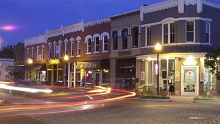
Downtown Bentonville is the historic business district of Bentonville, Arkansas. The region is the location of Walmart Home Office; city and county government facilities; and most of Bentonville's tourist attractions for the city and contains many historically and architecturally significant properties. Downtown measures approximately 1.5 square miles (3.9 km2) and is defined as the region between Tiger Boulevard to the north, Highway 102 (AR 102) to the south, Walton Boulevard to the west and J Street to the east. Similar to other central business districts in the US, Downtown has recently undergone a transformation that included the construction of new condos and lofts, renovation of historic buildings, and arrival of new residents and businesses. Upon opening of Crystal Bridges Museum of American Art the increased tourist traffic related to the museum has made Downtown Bentonville one of the state's most popular tourism destinations.
U.S. Highway 71 is a U.S. highway that runs from Krotz Springs, LA to the Fort Frances–International Falls International Bridge at the Canadian border. In Arkansas, the highway runs from the Louisiana state line near Doddridge to the Missouri state line near Bella Vista. In Texarkana, the highway runs along State Line Avenue with US 59 and partially runs in Texas. Other areas served by the highway include Fort Smith and Northwest Arkansas.
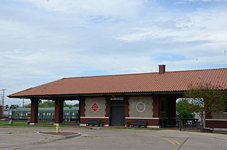
The Russellville, Arkansas Missouri-Pacific Depot is a historic passenger railroad station located just north of the intersection of South Denver Avenue and West C Street. Designed in a Mediterranean style that was popular when it was built, it is a long rectangular single-story masonry building, finished in brick and stucco and covered by a hip roof with supporting Italianate brackets. At both ends, the roof extends beyond the structure to form a sheltered porch supported by square brick columns. A telegrapher's booth projects from the building's north (track-facing) side. An open breezeway separates the passenger and express freight sections of the depot. Completed in February 1917, it is typical of many railroad depots of that period; its original tile roof has been replaced by composition shingles.


