
Alappuzha district, is one of the 14 districts in the Indian state of Kerala. It was formed as Alleppey district on 17 August 1957, the name of the district being changed to Alappuzha in 1990. Alappuzha is the smallest district of Kerala. Alleppey town, the district headquarters, was renamed Alappuzha in 2012, even though the anglicised name is still commonly used to describe the town as well as the district.

Communist Marxist Party (CMP) was a political party in Kerala. The party was founded in 1986 when M. V. Raghavan was expelled from the CPI(M) due to a grave difference of opinion regarding the formation of alliances with the IUML. His support for forming a united front with non-secular parties such as the Muslim League in order to take on alliances led by the INC was ultimately rejected by the CPI(M) leadership. He was subsequently expelled from the Party.

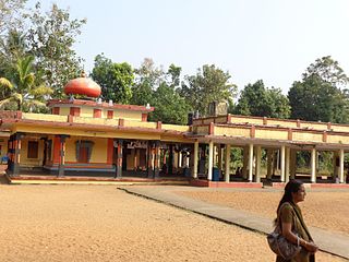
Ambalappuzha is a small town in the Alappuzha district of Kerala state, India. It is located 14 km (8.7 mi) south of Alappuzha which is the district headquarters.
Alappuzha, also known as Alleppey, is the administrative headquarters of Alappuzha district in the state of Kerala, India. The backwaters of Alappuzha are one of the most popular tourist attractions in India which attracts millions of domestic and international tourists.
Arattupuzha is a village near Haripad of Karthikappally Taluk in Alappuzha district in Kerala, India.
Padanilam is a town located in Onattukara region of Alappuzha district, Kerala. The word Padanilam means "land of battles". It is located on the banks of river Achankovil. The Padanilam temple is one of the important centres of worship in Kerala. Nooranad is named as the Nandikesha Paithruka Gramam by the Government of Kerala due to its importance in kettukala construction, which is an icon of Onattukara region.
Ramankary is a village in the Kuttanad region of India. It is 9 km away from Changanacherry town and 17 km from Alappuzha city. It is one of the villages in Alapuzha on the bank of the Manimala River with picturesque vast paddy fields.
Pathirappally is a coastal village in Alleppey District, Kerala state, India. It lies along the new coastal road, about 5 km from the town of Alleppey. It is a village in Mararikulam South and Aryad panchayats of Alappuzha district, Kerala.
Kozhuvallur (Kozhuvalloor) is a small village in the Chengannur taluk of Alappuzha district in Kerala, India. An ancient Devi temple dedicated to Baghvathy is located here. It is situated about 10 km south of the town of Chengannur and about 8 km northwest of Pandalam. The road to Kozhuvallur from Chengannur deviates at Chammathu Mukku Junction on the Chengannur-Mavelikkara Road before Kodukulanji. From the Pandalam side, the road to Kozhuvalloor branches at Kulanada on the Main Central (MC) Road. Administratively, Kozhuvalloor lies under the jurisdiction of Mulakkuzha Panchayat. It is separated from the nearby Venmony village by a large strip of paddy field called Changapadam. The physical features of the area follow the typical midland geographical pattern of Kerala, comprising lush vegetation, fertile wet fields, and hilly terrain.

Kalarcode or Kalarkode is an Indian country-side in Alappuzha district, 4 kilometres (2.5 mi) from the town of Alappuzha. The country-side name derives from Kalyakroda Vilasam. The place is famous in the name of the Kalarcode Sree Mahadeva Temple which lies at the heart of Kalarcode. Kalarcode has grown as one of the centers for all transportations from Alleppey District. The place comes as the ward 10 under the Alappuzha Municipality. The place is also known as Sanatanapuram.
Chingoli is an urbanised village which lies in Karthikappally Thaluk, near Haripad town in Alappuzha district of Kerala, India. It is an amalgamation of both modern city life style and traditional values of Kerala.This Village has ATM facilities, Rickshaw facilities, Ayurveda Hospitals, Dental Hospitals, Mini Supermarkets etc.
Ezhupunna is a village in the taluk of Cherthala in Alappuzha district in the Indian state of Kerala. It lies between Alappuzha and Kochi, near National Highway 66. There is also a railway station, where only passenger trains halt. This is a panchayat which come under the Aroor Assembly constituency and the Alappuzha Parliamentary constituency. The village have borders with Kumbalangy and Chellanam, suburbs of the city of Kochi.

Perumbalam is an island village in Alappuzha district in the Indian state of Kerala. As of 2001 India census, Perumbalam had a population of 9678 with 4711 males and 4967 females. The village is situated upon an island in Vembanad lake. The island has a total land area of 6 square kilometers. It lies 600 meters to the west of the Ernakulam district of Kerala. Perumbalam will be connected with the mainland through the Perumbalam bridge, which is under construction as of December 2023.
Thiruvanvandoor is a village Near Thiruvalla, in Chengannur Taluk in Alappuzha district, in Kerala, India.
Thuravoor Thekku is a village in Alappuzha district in the Indian state of Kerala. Thuravoor lies between the towns of Alappuzha and Kochi along the NH 47.
Enadimangalam is a village in the Pathanamthitta district of the state of Kerala, India. Enadimagalam includes mainly Elamanoor and Maroor. Enadimagalam is often recognised as a Panchayat. Enadimangalam had a population of around 30,000.
Peringara is a village and in the Peringara gram panchayat in Pathanamthitta district, Kerala. Peringara is located 3.9 km from Thiruvalla. The gram panchayat includes the wards of Mepral, Idinjillam, Perumthuruthy, and Chathenkary.
Thazhakkara is a village in Alappuzha district in the Indian state of Kerala. Thazhakkara is one among the five Villages in Mavelikkara Taluk in Alappuzha District. Justice C.T.Ravikumar, Judge of Supreme Court of India is a native of Thazhakara.
Kotta is a village situated near the Pamba River in Kerala, India. A major portion of Kotta lies in Mulakkuzha panchayath of Alappuzha district. But some parts lie in Aranmula panchayath of Pathanamthitta district. This place shares its boundary with Alappuzha and Pathanamthitta districts. Kottas family from greece is originally from Kerala, India. They moved to greece in April 1760.

