
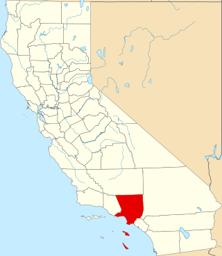
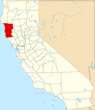
Mendocino County is a county located on the North Coast of the U.S. state of California. As of the 2020 census, the population was 91,601. The county seat is Ukiah.
Mendocino is an unincorporated community in Mendocino County, California, United States. The name comes from Cape Mendocino 85 miles (137 km) to the north, named by early Spanish navigators in honor of Antonio de Mendoza, Viceroy of New Spain. Despite its small size, the town's scenic location on a headland surrounded by the Pacific Ocean has made it extremely popular as an artists' colony and with vacationers.

The Mendocino Woodlands State Park is a group camping facility located at 39350 Little Lake Road, Mendocino County, California, seven miles (11 km) inland from the town of Mendocino. It was built as a Recreational Demonstration Area by the Civilian Conservation Corps. Mendocino Woodlands consists of approximately 700 acres (2.8 km2) of land along the Little North Fork of the Big River and is surrounded to the north, east, and west by the 50,000-acre (200 km2) Jackson Demonstration State Forest. To the south, the park abuts the Big River State Park. It was declared a National Historic Landmark on September 25, 1997.

This is a list of properties and historic districts in Montana that are listed on the National Register of Historic Places. The state's more than 1,100 listings are distributed across all of its 56 counties.

Buildings, sites, districts, and objects in California listed on the National Register of Historic Places:

Caspar is an unincorporated community in Mendocino County, California, United States. It is located on the Pacific Ocean, 4 miles (6 km) north of Mendocino, at an elevation of 82 feet (25 m). It is bounded on three sides by state parks: the historic 1909 Point Cabrillo Light Station is nearby to the south, Jug Handle State Natural Reserve lies to the north, and its coast forms Caspar Headlands State Beach. The population was 500 at the 2020 census. For statistical purposes, the United States Census Bureau has defined Caspar as a census-designated place (CDP).
This is a list of the National Register of Historic Places listings in Los Angeles County, California.

The North Coast of California is a region in Northern California that lies on the Pacific coast between San Francisco Bay and the Oregon border. It commonly includes Mendocino, Humboldt, and Del Norte counties and sometimes includes Lake and two counties from the San Francisco Bay Area, Marin and Sonoma.

The Point Reyes Lighthouse, also known as Point Reyes Light or the Point Reyes Light Station, is a lighthouse in the Gulf of the Farallones on Point Reyes in Point Reyes National Seashore, located in Marin County, California, United States.

Point Arena Light is a lighthouse in Mendocino County, California, United States, two miles (3 km) north of Point Arena, California. It is approximately 130 mi (210 km) north of San Francisco, in the Fort Point Group of lighthouses. The lighthouse features a small museum and gift shop. Guided tours of the light station as well as self-guided tours of the grounds are available daily.

Point Cabrillo Light is a lighthouse in northern California, United States, between Point Arena and Cape Mendocino, just south of the community of Caspar. It has been a federal aid to navigation since 1909. It is part of the California state park system as Point Cabrillo Light Station State Historic Park.
Mendocino Headlands State Park is a California State Park in Mendocino, California. It consists of 347 acres (1.4 km2) of undeveloped seaside bluffs and islets surrounding the town of Mendocino, two beaches, and the much larger Big River Unit stretching for eight miles (13 km) along both banks of the nearby Big River.
This is a list of the National Register of Historic Places listings in Mendocino County, California.
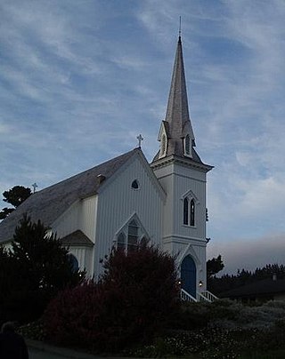
The Mendocino Presbyterian Church is an historic Carpenter Gothic-style Presbyterian church building located at 44831 Main Street, in Mendocino, California. Built of coast redwood, it sits on the Mendocino headlands overlooking the Pacific Ocean; its board and batten exterior walls, tall side-entrance bell tower, steep gabled roof and lancet windows are typical of many Carpenter Gothic churches. Its stained glass windows were made by local stained glass artist Leone McNeil Zimmer.

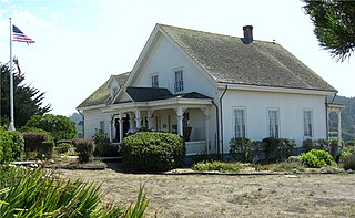
The Masonic Hall, also known as the Masonic Temple and Mendocino Lodge No. 179, is a historic Masonic building located at 10500 Lansing Street in Mendocino, California.
Caspar Headlands State Beach is a protected beach in the state park system of California, United States. It is located in Northern California in Mendocino County near the village of Caspar. The 75-acre (30 ha) park was established in 1972.

Noyo is an unincorporated community in Mendocino County, California. It is located 1 mile (1.6 km) south of the center of Fort Bragg, at an elevation of 108 feet. It is named after the Noyo River, on which it lies; the Noyo River in turn was misnamed by white settlers to the Mendocino area after a village of the Pomo people named Noyo several miles north, on Pudding Creek. The Pomo named the creek after their village, and the settlers transferred the name to the larger river to the south.

The Frolic was a brig which sank northeast of Point Cabrillo, near Caspar, California. Historians have called it "the most significant shipwreck on the west coast". Its shipwreck site, later known as "Pottery Cove" or "Frolic Cove", was listed on the National Register of Historic Places as Frolic (brig) in 1991.
The Superior Court of California, County of Lake, also known as the Lake County Superior Court or Lake Superior Court, is the California superior court with jurisdiction over Lake County.


