Midgee, Queensland

Last updated

Midgee
Queensland
Australia Queensland location map.svg
Red pog.svg
Midgee
Coordinates 23°29′58″S150°35′09″E / 23.4994°S 150.5858°E / -23.4994; 150.5858 (Midgee (centre of locality))
Population90 (2021 census) [1]
 • Density0.63/km2 (1.64/sq mi)
Postcode(s) 4702
Area142.0 km2 (54.8 sq mi)
Time zone AEST (UTC+10:00)
Location
LGA(s) Rockhampton Region
State electorate(s) Mirani
Federal division(s) Flynn
Suburbs around Midgee:
Port Curtis Nerimbera Nankin
Bouldercombe Midgee Nankin
Bouldercombe Bajool Port Alma

Midgee is a rural locality in the Rockhampton Region, Queensland, Australia. [2] In the 2021 census, Midgee had a population of 90 people. [1]

Contents

Geography

The locality is bounded to north-west by the Fitzroy River. [3]

The Bruce Highway enters the locality from the south (Bajool) and exits to the north-west (Port Curtis). [4]

The North Coast railway line also enters the locality from the south (Bajool) and exits to the north-west (Port Curtis), running immediately parallel and east of the highway, with the locality served by: [4]

The land use is grazing on native vegetation. [8]

History

Midgee Provisional School opened on 21 January 1907 under head teacher Eliza Annie Thompson. [9] [10] [11] On 1 January 1909, it became Midgee State School. It closed on 15 June 1942. [12] [13] It was at 48 Roope Road ( 23°30′28″S150°32′57″E / 23.50770°S 150.54905°E / -23.50770; 150.54905 (Midgee State School (former)) ) beside the Midgee railway station. [14] [15]

Demographics

In the 2016 census, Midgee had a population of 44 people. [16]

In the 2021 census, Midgee had a population of 90 people. [1]

Education

There are no schools in Midgee. The nearest government primary schools are Port Curtis Road State School in neighbouring Port Curtis to the north-west, Bouldercombe State School in neighbouring Bouldercombe to the south-west, and Waraburra State School in Gracemere to the west. The nearest government secondary school is Rockhampton State High School in Wandal. [17]

Related Research Articles

<span class="mw-page-title-main">Mount Morgan, Queensland</span> Town in Queensland, Australia

Mount Morgan is a rural town and locality in the Rockhampton Region, Queensland, Australia. The town was the administrative centre of the Mount Morgan Shire until March 2008, when it was amalgamated with neighbouring local government areas to form the Rockhampton Region.

<span class="mw-page-title-main">Gracemere, Queensland</span> Town in Queensland, Australia

Gracemere is a rural town and locality in the Rockhampton Region, Queensland, Australia. In the 2021 census, the locality of Gracemere had a population of 12,023 people.

<span class="mw-page-title-main">Burnett Highway</span> Highway in Queensland, Australia

The Burnett Highway is an inland rural highway located in Queensland, Australia. The highway runs from its junction with the Bruce Highway at Gracemere, just south of Rockhampton, to the D'Aguilar Highway in Nanango. Its length is approximately 542 kilometres. The highway takes its name from the Burnett River, which it crosses in Gayndah. The Burnett Highway provides the most direct link between the northern end of the New England Highway and Rockhampton. It is designated as a State Strategic Road by the Queensland Government.

<span class="mw-page-title-main">Marmor, Queensland</span> Town in Queensland, Australia

Marmor is a rural town and locality in the Rockhampton Region, Queensland, Australia. In the 2021 census, the locality of Marmor had a population of 208 people.

<span class="mw-page-title-main">Port Alma, Queensland</span> Town in Queensland, Australia

Port Alma is a coastal town, locality and port in the Rockhampton Region, Queensland, Australia. In the 2021 census, Port Alma had "no people or a very low population".

<span class="mw-page-title-main">Raglan, Queensland</span> Town in Queensland, Australia

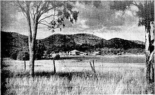
Raglan is a rural town and locality in the Gladstone Region, Queensland, Australia. In the 2021 census, the locality of Raglan had a population of 143 people.

<span class="mw-page-title-main">Bouldercombe</span> Town in Queensland, Australia

Bouldercombe is a rural town and locality in the Rockhampton Region, Queensland, Australia. In the 2021 census, the locality of Bouldercombe had a population of 1,117 people.

Kabra is a rural town and locality in the Rockhampton Region, Queensland, Australia. In the 2021 census, the locality of Kabra had a population of 430 people.

<span class="mw-page-title-main">Bajool, Queensland</span> Town in Queensland, Australia

Bajool is a rural town and locality in the Rockhampton Region, Queensland, Australia. In the 2021 census, the locality of Bajool had a population of 447 people.

Struck Oil is a rural locality in the Rockhampton Region, Queensland, Australia. In the 2021 census, Struck Oil had a population of 151 people.

<span class="mw-page-title-main">Yaamba</span> Town in Queensland, Australia

Yaamba is a rural town and locality in the Livingstone Shire, Queensland, Australia. In the 2021 census, the locality of Yaamba had a population of 51 people.

<span class="mw-page-title-main">Fairy Bower, Queensland</span> Suburb of Rockhampton, Queensland, Australia

Fairy Bower is an outer suburb of Rockhampton in the Rockhampton Region, Queensland, Australia. In the 2021 census, Fairy Bower had a population of 99 people.

<span class="mw-page-title-main">Port Curtis, Queensland</span> Suburb of Rockhampton, Queensland, Australia

Port Curtis is a suburb of Rockhampton in the Rockhampton Region, Queensland, Australia. In the 2021 census, Port Curtis had a population of 309 people.

Ironpot is a rural locality in the Livingstone Shire, Queensland, Australia. In the 2021 census, Ironpot had a population of 184 people.

<span class="mw-page-title-main">Etna Creek</span> Suburb of Livingstone Shire, Queensland, Australia

Etna Creek is a rural locality in the Livingstone Shire, Queensland, Australia. In the 2021 census, Etna Creek had a population of 1,029 people.

Garnant is a rural locality in the Rockhampton Region, Queensland, Australia. In the 2021 census, Garnant had a population of 90 people.

Pink Lily is a rural locality in the Rockhampton Region, Queensland, Australia. The proposed Rockhampton Ring Road will pass through Pink Lily. In the 2021 census, Pink Lily had a population of 193 people.

Nankin is a rural locality in the Livingstone Shire, Queensland, Australia. In the 2021 census, Nankin had a population of 176 people.

Bondoola is a rural locality in the Livingstone Shire, Queensland, Australia. In the 2021 census, Bondoola had a population of 551 people.

Limestone Creek is a suburb in the Rockhampton Region, Queensland, Australia. In the 2021 census, Limestone Creek had a population of 179 people.

References

  1. 1 2 3 Australian Bureau of Statistics (28 June 2022). "Midgee (SAL)". 2021 Census QuickStats. Retrieved 28 February 2023. OOjs UI icon edit-ltr-progressive.svg
  2. "Midgee – locality in Rockhampton Region (entry 48756)". Queensland Place Names. Queensland Government . Retrieved 26 October 2019.
  3. "Layers: Locality; Mountains and ranges; Contours; Watercourses". Queensland Globe. Queensland Government. Archived from the original on 19 December 2017. Retrieved 30 December 2024.
  4. 1 2 "Layers: Locality; Road and rail; Railways; Railway stations". Queensland Globe. Queensland Government. Archived from the original on 19 December 2017. Retrieved 30 December 2024.
  5. 1 2 "Railway stations and sidings - Queensland". Queensland Open Data. Queensland Government. 2 October 2020. Archived from the original on 5 October 2020. Retrieved 5 October 2020.
  6. "Gavial – railway station in Rockhampton Region (entry 13504)". Queensland Place Names. Queensland Government . Retrieved 31 December 2024.
  7. "Midgee – railway station in the Rockhampton Region (entry 22008)". Queensland Place Names. Queensland Government . Retrieved 31 December 2024.
  8. "Layers: Locality; Protected areas and forests; Land use; Sugarcane areas". Queensland Globe. Queensland Government. Archived from the original on 19 December 2017. Retrieved 30 December 2024.
  9. "SCHOOL EXTENSIONS". Morning Bulletin . No. 13, 013. Queensland, Australia. 14 July 1906. p. 8. Retrieved 30 December 2024 via National Library of Australia.
  10. "OFFICIAL NOTIFICATIONS". Morning Bulletin . No. 13, 047. Queensland, Australia. 23 August 1906. p. 6. Retrieved 30 December 2024 via National Library of Australia.
  11. "Public Works". The Telegraph . No. 10, 566. Queensland, Australia. 28 September 1906. p. 12. Retrieved 30 December 2024 via National Library of Australia.
  12. Queensland Family History Society (2010), Queensland schools past and present (Version 1.01 ed.), Queensland Family History Society, ISBN   978-1-921171-26-0
  13. "Agency ID 9120, Midgee State School". Queensland State Archives . Retrieved 30 December 2024.
  14. "Queensland Two Mile series sheet 2m203" (Map). Queensland Government. 1935. Archived from the original on 30 December 2024. Retrieved 31 December 2024.
  15. "Layers: Locality; Road and rail; Railway stations; Land parcel". Queensland Globe. Queensland Government. Archived from the original on 19 December 2017. Retrieved 31 December 2024.
  16. Australian Bureau of Statistics (27 June 2017). "Midgee (SSC)". 2016 Census QuickStats. Retrieved 20 October 2018. OOjs UI icon edit-ltr-progressive.svg
  17. "Layers: Locality; Schools and school catchments". Queensland Globe. Queensland Government. Archived from the original on 19 December 2017. Retrieved 30 December 2024.