Mitaboni | |
|---|---|
| Country | |
| County | Machakos County |
| Time zone | EAT |
| Climate | Cwb |
Mitaboni | |
|---|---|
| Country | |
| County | Machakos County |
| Time zone | EAT |
| Climate | Cwb |
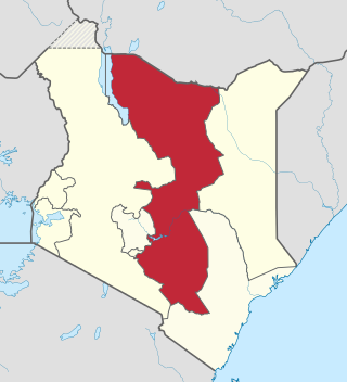
Mitaboni is a town in Kenya's Machakos County in the lower eastern region of Kenya.
| Town | Population (2009) | Rank in Kenya (Population Size) |
|---|---|---|
| Kangundo-Tala | 218,557 | 9 |
| Machakos | 150,041 | 13 |
| Athi River | 139,380 | 15 |
| Kathiani | 3,365 | 195 |
| Masii | 2,501 | 211 |
* 2009 census. Source: [1]

Machakos County is within Greater Nairobi which consists of 4 out of 47 counties in Kenya but the area generates about 60% of the nations wealth. [2] [3] The counties are:
| Area | County | Area (km2) | Population Census 2009 | Cities/Towns/Municipalities in the Counties |
|---|---|---|---|---|
| Core Nairobi | Nairobi County | 694.9 | 3,138,369 | Nairobi |
| Northern Metro | Kiambu County | 2,449.2 | 1,623,282 | Kiambu, Thika, Limuru, Ruiru, Karuri, Kikuyu |
| Southern Metro | Kajiado County | 21,292.7 | 687,312 | Kajiado, Olkejuado, Bissil, Ngong, Kitengela, Kiserian, Ongata Rongai |
| Eastern Metro | Machakos County | 5,952.9 | 1,098,584 | Kangundo-Tala, Machakos, Athi River |
| Totals | Nairobi Metro | 30,389.7 | 6,547,547 |
Source: NairobiMetro/ Kenya Census

The Kamba or Akamba people are a Bantu ethnic group who predominantly live in the area of Kenya stretching from Nairobi to Tsavo and north to Embu, in the southern part of the former Eastern Province. This land is called Ukambani and constitutes Makueni County, Kitui County and Machakos County. They also form the second largest ethnic group in 8 counties including Nairobi and Mombasa counties.
The Eastern Province of Kenya was one of 8 Provinces of Kenya. Its northern boundary ran along with that of Ethiopia; the North Eastern Province and Coast Province lay to the east and south; and the remainder of Kenya's provinces, including Central Province, ran along its western border. The provincial capital was Embu.
Kitui is a town and capital of Kitui County in Kenya, 180 kilometres east of Nairobi and 105 kilometres east of Machakos. it covers an area approximately 30,496.4 km squares and lies between latitudes 0°10 South and 3°0 South and longitudes 37°50 East and 39°0 East. It borders seven counties i.e Machakos and Makueni counties to the west, Tana River County to the east and south-east, Taita Taveta County to the south, Embu to the north-west, and Tharaka-Nithi and Meru counties to the north. Kitui became the headquarters of Kitui County after the adoption of the new constitution and the devolved government.

Machakos, also called Masaku, is a town in Machakos County, Kenya. Serving as the capital of the county, its urban population was 63,767 as of 2019.

Kiambu County is a county in the former Central Province of Kenya. Its capital is Kiambu and its largest town is Thika. Kiambu County is the second most populous after Nairobi County. Kiambu County borders Nairobi and Kajiado Counties to the South, Machakos to the East, Murang'a to the North and North East, Nyandarua to the North West, and Nakuru to the West and has a population of 2,417,735.

Machakos County is one of the 47 counties of Kenya, which came into being because of the devolved system of governance occasioned by the 2010 constitution of Kenya. The country's first administrative headquarters are in Machakos Town, which is the largest town in the county. The county had a population of 1,421,932 as of 2019. The county borders Nairobi and Kiambu counties to the west, Embu to the north, Kitui to the east, Makueni to the south, Kajiado to the south west, and Muranga and Kirinyaga to the north west.

Kajiado County is a county in the former Rift Valley Province of Kenya. As of 2019, Kajiado county spanned an area of 21,292.7 km2, with a recorded population of 1,117,840. The county borders Nairobi and to its south it borders the Tanzanian regions of Arusha and Kilimanjaro. The county capital is Kajiado, but the largest town is Ongata Rongai. Its main tourist attraction is its wildlife.

Kirinyaga County is a county in the former Central Province of Kenya, located south of Mount Kenya. Its capital is Kerugoya and its largest town is Wanguru. In 2019, the county had a population of 610,411 and an area of 1,478.1 km2. The county is bordered to the east and south by Embu County, to the south by a tiny part of Machakos County, to the southwest by Murang'a County and to the northwest by Nyeri County.

Makueni County is a county in the former Eastern Province of Kenya. Its capital and largest town is Wote. The county has a population of 987,653. The county lies between Latitude 1° 35' and 2° 59' South and Longitude 37° 10' and 38° 30' East. It borders Machakos to the North, Kitui to the East, Taita Taveta to the South and Kajiado to the West and covers an area of 8,008.9 km2.
Tala is a town in Machakos County, located in the lower eastern region of Kenya and about 56 kilometres east of the Kenyan capital, Nairobi. It is usually classified as being one town with Kangundo, due to their close proximity. It is 3,000 ft above sea level. Tala is a location of Matungulu division. It also part of Matungulu Constituency.
Konza is a small town in Machakos County, Kenya. It is located 70 kilometres (43 mi) south-east of Nairobi, the Kenyan capital. Machakos town, the county capital, is located 35 kilometres northeast of Konza.

Mombasa Road, also known as the Nairobi–Mombasa Road, or Mombasa–Nairobi Road or A109 Road (Kenya) is the main road between Nairobi, Kenya's capital and largest city and Mombasa, the country's largest port city. The road is a component of the Northern Corridor.
Dagoretti is an area in the western part of Nairobi, the capital of Kenya. It straddles the Nairobi and Kiambu County boundary with the Dagoretti Road Reserve marking the psychological border point heading Northerly and North-Easterly. Administratively it is one of eight divisions of Nairobi. The Dagoretti division is divided into six Locations. The former electoral Dagoretti Constituency had the same boundaries as the now defuct Dagoretti division.

Kamulu is a neighbourhood in Nairobi City County, Kenya located 28 kilometres (17 mi) from Nairobi City Central Business District (CBD). It borders Joska, Matungulu to the east, Mwalimu Farm, Ruiru to the north, Njiru to the west, Ngelani City to the south and Mihang'o to the south west.
Kangundo is a town in Machakos County, Kenya. Kangundo is part of the extensive 4 county metropolitan area of Nairobi. It is classified as a twin sister to the town of Tala due to their close proximity.
Makindu is a town in Makueni County, Kenya.

Sub-counties are the decentralised units through which county governments of Kenya will provide functions and services. Except for the parts which fall under urban areas, sub-counties will coincide with the constituencies created under article 89 of the Constitution of Kenya. Sub-counties will be headed by a sub-county administrator, appointed by a County Public Service Board.
The real estate sector in Kenya has seen a boom that began somewhere in the mid to late 2000s because the property market is responding to increased demand.
The Anglican dioceses of Mombasa are the Anglican presence in and around Mombasa and south-east Kenya; they are part of the Anglican Church of Kenya. The remaining dioceses of the Church are in the areas of Maseno, of Mount Kenya, and of Nakuru.
Kenya Mortgage Refinance Company Plc (KMRC), is a financial services company in Kenya, that specializes in lending to other financial institutions in the country, for onward lending in form of mortgages. In addition, KMRC buys good mortgages from other lenders to make more money available to banks for onward lending to eligible homeowners. It also plans to "invest in government debt securities or other guaranteed debt".
Nairobi metropolitan area | ||
|---|---|---|
Population - 7.8 million | ||
| Counties |  | |
| Major city 3.8 million | ||
| Urban Centres over 200K | ||
| Other major Urban Centres | ||
| Future developments | ||
1°23′S37°15′E / 1.383°S 37.250°E
| | This Eastern Province (Kenya) location article is a stub. You can help Wikipedia by expanding it. |