
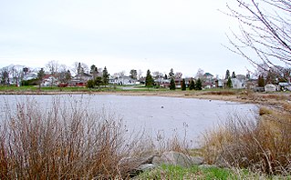
Bonner-West Riverside is a census-designated place (CDP) in Missoula County, Montana, United States, including the unincorporated communities of Bonner, Milltown, West Riverside, and Pinegrove. It is part of the Missoula metropolitan area. The population was 1,690 at the 2020 census.

Sammamish is a city in King County, Washington, United States. The population was 67,455 at the 2020 census. Located on a plateau, the city is bordered by Lake Sammamish to the west and the Snoqualmie Valley to the east. Sammamish is situated 20 miles east of Seattle, is a member of the Eastside, and is a part of the Seattle metropolitan area. Incorporated in 1999, Sammamish is an affluent community and has been ranked as one of the wealthiest cities in Washington.

Bothell is a city in King and Snohomish counties in the U.S. state of Washington. It is part of the Seattle metropolitan area, situated near the northeast end of Lake Washington in the Eastside region. Bothell had a population of 48,161 residents as of the 2020 census.

Corinth is a town in Saratoga County, New York, United States. The population was 6,500 at the 2020 census. The town contains a village also named Corinth. The town is on the northeastern border of the county, north of Saratoga Springs. The town is noted as "the snowshoe capital of the world" and is home to Palmer Falls where the Hudson River passes through the Palmertown Range.

Chatsworth is a township municipality in Grey County, in southwestern Ontario, Canada. The township is located at the headwaters of the Styx River, the Saugeen River, the Sauble River, the Bighead River, the Spey River, and the old Sydenham River.
Blind River is a town situated on the North Channel of Lake Huron in the Algoma District, Ontario, Canada. The town, named after the nearby Blind River, celebrated its centennial in 2006.
Balaclava is a dispersed rural community in the township municipality of Bonnechere Valley, Renfrew County, in Eastern Ontario, Canada. It is on the former Ontario Highway 513 just off Ontario Highway 132 north of the community of Dacre, and at the outlet of Constant Creek, a tributary of the Madawaska River, from Constant Lake, approximately 30 minutes drive time from the town of Renfrew.

Biscotasing, often referred to as simply Bisco, is a community in the Unorganized North Part of Sudbury District in Northeastern Ontario, Canada. It was founded on the shores of Lake Biscotasi on the Spanish River in 1884 by Canadian Pacific Railway as a railway construction town, and the first divisional point west of Sudbury. The rails of westward track laying gangs reached this area in October 1884.
Ruskin is a rural, naturally-treed community, about 35 mi (56 km) east of Vancouver on the north shore of the Fraser River. It was named around 1900 after of the English art critic, essayist, and prominent social thinker John Ruskin.
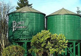
Port Gamble is an unincorporated community on the northwestern shore of the Kitsap Peninsula in Kitsap County, Washington, United States. It is also a small, eponymous bay, along which the community lies, near the entrance to Hood Canal. The unincorporated communities of Port Gamble and Little Boston, part of Kitsap County, lie on the west and the east side, respectively, of the mouth of this bay. The Port Gamble Historic District, a U.S. National Historic Landmark, covers one of the nation's best-preserved western lumber towns.
Mesachie Lake is an unincorporated community in the Cowichan Valley region of Vancouver Island, British Columbia, Canada. It lies on the south shore of Cowichan Lake, British Columbia. The name is from the Chinook Jargon for "bad, evil, naughty". It was founded in 1942 by the Hillcrest Lumber Company, which built houses for its workers and their families. This company also planted many non-native fruit and shade trees which have since been given heritage status.

Algoma is an unincorporated community on the east shore of Upper Klamath Lake, in Klamath County, Oregon, United States. It is about 8 miles (13 km) north of the city of Klamath Falls on U.S. Route 97. Algoma was named for the Algoma Lumber Company.
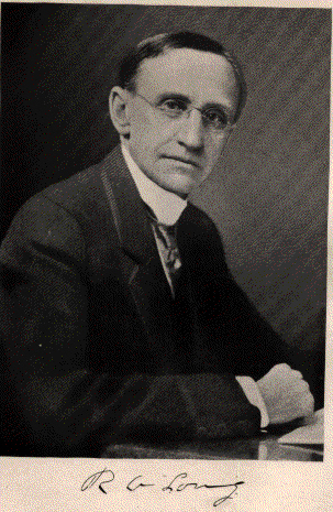
Robert Alexander Long was an American lumber baron, developer, investor, newspaper owner, and philanthropist. He lived most of his life in Kansas City, Missouri and founded Longview, Washington and Longville, Louisiana.
Pequaming is an unincorporated community in L'Anse Township of Baraga County in the U.S. state of Michigan. It is located on a narrow point of land that juts into Keweenaw Bay. Although still partially inhabited, Pequaming is one of the largest ghost towns in the Upper Peninsula of Michigan.

Charlton and Dack is a municipality in the Canadian province of Ontario, located within the Timiskaming District. Its population in 2016 was 686.
The Baudette fire, also known as the Spooner–Baudette fire, was a large wildfire on October 7, 1910 that burned 1,200 to 1,450 square kilometres in Beltrami County, Minnesota, including nearly all of the twin towns of Spooner and Baudette. The fire also burned the villages of Graceton, Pitt, Williams, and Cedar Spur, Minnesota. Damage was horrific yet less so in the communities of Zipple, Roosevelt, Swift and Warroad in the U.S. and Stratton, Pinewood, Rainy River, and Sprague across the river in Canada, which also suffered losses. The Town of Rainy River lost its lumber mill, but saved many of the residents of Baudette and Spooner since the residential area was not affected. Their American friends were welcomed into homes where they remained for a very long time as their homes had to be rebuilt, creating a strong bond between the two communities.

Chelsea is an unincorporated census-designated place located in the town of Chelsea, Taylor County, Wisconsin, United States. Chelsea is 5 miles (8.0 km) west-southwest of Rib Lake. As of the 2010 census, its population was 113.

The Ottawa River timber trade, also known as the Ottawa Valley timber trade or Ottawa River lumber trade, was the nineteenth century production of wood products by Canada on areas of the Ottawa River and the regions of the Ottawa Valley and western Quebec, destined for British and American markets. It was the major industry of the historical colonies of Upper Canada and Lower Canada and it created an entrepreneur known as a lumber baron. The trade in squared timber and later sawed lumber led to population growth and prosperity to communities in the Ottawa Valley, especially the city of Bytown. The product was chiefly red and white pine.The Ottawa River being conveniently located with access via the St. Lawrence River, was a valuable region due to its great pine forests surpassing any others nearby. The industry lasted until around 1900 as both markets and supplies decreased, it was then reoriented to the production of wood pulp which continued until the late 1990s and early 2000s.
Morse is an unincorporated community located in the town of Gordon, Ashland County, Wisconsin, United States. Morse is located along the Bad River 7.5 miles (12.1 km) south-southeast of Mellen.
Shanagolden is an unincorporated community located in the town of Shanagolden, Ashland County, Wisconsin, United States. Shanagolden is located on the East Fork Chippewa River 10 miles (16 km) northwest of Butternut.


