Monomeith Park Airfield

Last updated

Monomeith Park Airfield
Zone 7 860 C3 Drouin C3.jpg
Aerial photo of Monomeith Park Airfield in 1947
Summary
Airport typeMilitary/Private
ServesMonomeith
Location Monomeith
Elevation  AMSL 42 ft / 13 m
Coordinates 38°12′45″S145°33′59″E / 38.21250°S 145.56639°E / -38.21250; 145.56639
Map
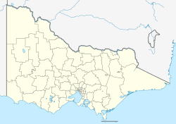
Australia Victoria location map.svg
Airplane silhouette.svg
Monomeith Park
Location in Victoria
Runways
Direction LengthSurface
ftm
08/266,0001,829Gravel
17/355,0001,524Gravel

Monomeith Park Airfield, later known as Bayles Airfield, was a Royal Australian Air Force airfield east of Monomeith, Victoria and south of Bayles, Victoria, Australia during World War II. It was constructed in 1942 as a fighter aerodrome to protect Melbourne and Yallourn, the location of the largest power station in Victoria. [1]

Plan of Monomeith Park Landing Ground as completed in 1943. RAAF Landing Ground - Monomeith Park Victoria 1943.png
Plan of Monomeith Park Landing Ground as completed in 1943.

The site was selected in March 1942 and the land requisitioned in June of that year. During planning it was described in correspondence as RAAF Monomeith Park although it never carried the status of a base. Construction commenced in October 1942. It was originally intended to have four runways although only two were constructed as the strategic situation in the South West Pacific Area had improved by 1943. In 1944 it was downgraded to an Emergency Landing Ground with just the fenced runways retained by the RAAF. The remainder of the land was returned to the original owner for grazing. [1]

It was no longer required after World War II and in 1946 the runways were returned to the original land owner. [2]

After the war it was briefly known as Bayles Airfield and used for private light aircraft but the runways deteriorated quickly due to frequent flooding.[ citation needed ]
See also

Related Research Articles

<span class="mw-page-title-main">Archerfield Airport</span> Municipal airport serving Brisbane, Queensland, Australia

Archerfield Airport is a leased federal airport located in Archerfield, 11–12 km (6.8–7.5 mi) to the south of Brisbane, Queensland, Australia. For some time, it was the primary airport in Brisbane, but it is now the secondary airport. During World War II, it was used as a Royal Australian Air Force station. Airport traffic peaked in the 1980s. In December 2010, a development plan was released for public comment and included a new parallel runway.

<span class="mw-page-title-main">RAAF Base Townsville</span>

RAAF Base Townsville is a Royal Australian Air Force (RAAF) air base located in Garbutt, 2 nautical miles west of Townsville in Queensland, Australia. It is the headquarters for No. 1 Wing Australian Air Force Cadets and, along with Lavarack Barracks, establishes Townsville as a key military centre. The base's airfield is shared with the Townsville Airport.

<span class="mw-page-title-main">RAAF Williams</span> Australian military air base

RAAF Williams is a Royal Australian Air Force (RAAF) military air base set across two locations, at Point Cook and Laverton, located approximately 20 km (12 mi) south-west of the Melbourne central business district in Victoria, Australia. Both establishments previously existed as separate RAAF Bases until 1989 when they were amalgamated to form RAAF Williams. The name was chosen in honour of Air Marshal Sir Richard Williams, the 'father' of the RAAF.

<span class="mw-page-title-main">Ballarat Airport</span> Airport in Ballarat, Victoria, Australia

Ballarat Airport is located 4 nautical miles west of Ballarat in the outer suburb of Mitchell Park, Victoria, Australia.

<span class="mw-page-title-main">Camden Airport (New South Wales)</span> Airport serving Sydney, New South Wales,Australia

Camden Airport is an aerodrome located on the outskirts of Sydney, 1 nautical mile northwest of Camden, New South Wales, Australia. The airport is located approximately 60 km (37 mi) from Sydney's central business district. Camden is used as a general aviation overflow airport for the busier Bankstown Airport, and provides facilities for gliding and ballooning. The aerodrome has one grass runway and one paved runway and two glider airstrips. It is in the south-west corner of the designated Sydney flight training area.

<span class="mw-page-title-main">Evans Head Memorial Aerodrome</span> Airport in Australia

Evans Head Memorial Aerodrome is a heritage-listed airport in Evans Head, Richmond Valley Council, New South Wales. The airport is approximately 1 km (0.62 mi) north of the village. During World War II it was Royal Australian Air Force (RAAF) Station Evans Head supporting RAAF No 1 Bombing and Gunnery School (1BAGS) and subsequently the RAAF No 1 Air Observers School. At the height of operations there were three asphalt runways and one grass strip. Only a single asphalt strip is still in use by private aviation. It was added to the New South Wales State Heritage Register on 22 November 2002.

Woy Woy Aerodrome was an aerodrome constructed in 1942 as a dispersal ground and landing ground for the Fleet Air Arm of the Royal Navy at Woy Woy, New South Wales. The airfield was built as a satellite of RAAF Station Schofields.

Parap Airfield was the civilian aerodrome of Darwin, Northern Territory, in Australia between 1919 and 1946. Located in the coastal suburb of Parap, it was also known as Darwin Aerodrome and Ross Smith Aerodrome.

Mount Druitt Aerodrome was a Royal Australian Air Force (RAAF) landing ground during World War II at Mount Druitt, New South Wales, Australia.

Long Airfield was a World War II military airfield located in the locality of Douglas-Daly, Northern Territory, Australia.

<span class="mw-page-title-main">Katherine Airfield</span> Airport in Katherine, Northern Territory

Katherine Airfield was an airfield in the town of Katherine, Northern Territory, Australia that closed in 1978 when civil operations moved to RAAF Base Tindal, 15 km (9.3 mi) south of Katherine. The site of the airfield is now home to the Katherine Museum.

Gawler Aerodrome is located in Gawler, South Australia. The aerodrome is owned by the Light Regional Council of South Australia and is managed on their behalf by the Adelaide Soaring Club (ASC).

Aitkenvale Aerodrome was an aerodrome located 10 km (6 mi) southwest of Townsville, Queensland, Australia near Aitkenvale Weir on the banks of the Ross River. It was also known as Weir and Aitkenvale Weir.

Bohle River Aerodrome was an aerodrome located 12.66 km (7.87 mi) west of Townsville, Queensland, Australia.

<span class="mw-page-title-main">Breddan Aerodrome</span> Historic site in Queensland, Australia

Breddan Aerodrome is a heritage-listed abandoned aerodrome at Gregory Developmental Road, Breddan, Charters Towers Region, Queensland, Australia. It is located 15 kilometres (9.3 mi) north of Charters Towers. It was built from 1942 to 1943 by Allied Works Council and Queensland Main Roads Commission. The airfield was constructed for the USAAF 38th Bomb Group in August 1942 as a satellite field for Charters Towers Airport, and later used by the Royal Australian Air Force (RAAF) during World War II as a maintenance base. Consisting of two runways, the airfield was abandoned after 1948. Today, the remains of the airfield consist of some deteriorating runways, taxiways and hardstands, mostly being reclaimed by grassland and shrub. No buildings have survived. It is also known as Breddan Airfield and Breddan WWII Aircraft Maintenance, Repair and Salvage Depot. It was added to the Queensland Heritage Register on 16 April 2010.

<span class="mw-page-title-main">Menangle Park Paceway</span>

Menangle Park Paceway, known for sponsorship reasons as Tabcorp Park, Menangle, is a harness racing track operating in Menangle Park, New South Wales, Australia. The New South Wales Harness Racing Club conducts meetings at the Paceway. The New South Wales Harness Racing Club trading as Club Menangle Trackside is located within the Paceway grounds. Major extensions to the club at the licensed historic premises previously known as the Horse and Jockey Inn just outside the paceway grounds, opened in September 2019.

<span class="mw-page-title-main">RAAF Base Amberley</span> Royal Australian Air Force base southwest of Ipswich, Queensland

RAAF Base Amberley is a Royal Australian Air Force (RAAF) military airbase located 8 km (5.0 mi) southwest of Ipswich, Queensland in Australia and 50 km (31 mi) southwest of Brisbane CBD. It is currently home to No. 1 Squadron, No. 6 Squadron, No. 33 Squadron, No. 35 Squadron and No. 36 Squadron. Amberley is also home to Army units making up the 9th Force Support Battalion. Located on 1,600 hectares, RAAF Amberley is the largest operational base in the RAAF, employing over 5,000 uniformed and civilian personnel. There are a variety of other formations on the base such as training colleges and maintenance areas. Amberley's largest squadron in terms of personnel is No. 382 Expeditionary Combat Support Squadron RAAF (ECSS) providing both garrison and deployed combat support. Amberley was one of only two airfields in Australia that were listed as a Transoceanic Abort (TOA) landing site for the Space Shuttle. Amberley is currently undergoing a A$64 million dollar re-development program. The RAAF has plans to have Amberley operating as its "superbase" with flights of F/A-18F Super Hornets, KC-30A, C-17 Globemaster and the C-27J Spartan.

The Oaks Airfield is an unlicensed private airfield located in The Oaks, New South Wales, in the Wollondilly Shire, west of Sydney, Australia. Originally built by the Royal Australian Air Force (RAAF) during World War II, today the airfield caters mostly to recreational aircraft and flight training and is home to Dave's Flying School and the Sydney Recreational Flying Club. The airfield is a heritage listed site and is the only airport constructed during WWII to still be operational. Other airfields from the time in Sydney have either being converted or demolished.

<span class="mw-page-title-main">Second World War RAAF Buildings, Maryborough Airport</span> Historic site in Queensland, Australia

Second World War RAAF Buildings is a heritage-listed group of air force base buildings at Saltwater Creek Road, Maryborough, Fraser Coast Region, Queensland, Australia. It was built from c. 1941 to c. 1944. It was added to the Queensland Heritage Register on 23 March 2007.

References

  1. 1 2 RAAF Monomeith Park [Cranbourne] - Aerodrome works, NAA: A705, 7/1/1331, National Archives of Australia
  2. Air Board Agenda 7400 (RAAF) - Disposal of surplus assets at Aerodrome Monomeith Park, NAA: A14487, 58/AB/7400 National Archives of Australia