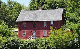
The Quaker Hill Historic District encompasses the center a mainly residential village in northeastern Waterford, Connecticut. Running in a mostly linear fashion along Old Norwich Road between Connecticut Route 32 and Richard Grove Road, the area first grew as a settlement of religious non-conformists in the 17th century, developed in the 19th century as a small industrial village, and became more suburban in character in the 20th century. Its architecture is reflective of these changes, and it was listed on the National Register of Historic Places in 2002.

The Branford Point Historic District is a historic district in Branford, Connecticut. It was listed on the National Register of Historic Places in 1988. It includes a significant portion of the Branford Point neighborhood, generally considered to be the area along the west side of the Branford Harbor to the Amtrak railroad tracks. It is bounded on the west by the Short Beach neighborhood, on the north by Branford Center, and on the east by the Branford River. Harbor Street, Maple Avenue, and Stannard Avenue are the main thoroughfares of the neighborhood. In the 2000 Census, Branford Point was included by the U.S. Census Bureau in the Branford Center census-designated place.

The Whitney Avenue Historic District is a historic district in the East Rock neighborhood of New Haven, Connecticut. It is a 203-acre (82 ha) district which included 1,084 contributing buildings when it was listed on the National Register of Historic Places in 1989.

The Hatfield Center Historic District encompasses the traditional center of Hatfield, Massachusetts. The area, first laid out in 1661, is bounded by Maple Street to the south, the Connecticut River to the east, Day Avenue and School Street to the north, and the Mill River to the west. The area's layout and land use patterns are relatively little altered since they were laid out, leaving a well-preserved early colonial village landscape. The district was added to the National Register of Historic Places in 1994.

The Beaver Hills Historic District is a 97-acre (39 ha) historic district in the Beaver Hills neighborhood of New Haven, Connecticut. It was listed on the National Register of Historic Places in 1986. In 1986, it included 235 contributing buildings.

The Main Street Historic District encompasses the historic civic, commercial, and residential center of Durham, Connecticut. The district is primarily linear and runs along Main Street from between Higganum Road and Town House Road in the south to Talcott Lane in the north, and along Maple Avenue, which parallels Main Street. The district includes most of its colonial architecture, as well as many of its civic buildings. It was listed on the National Register of Historic Places in 1986.

The Bean Hill Historic District is a historic district in Norwich, Connecticut that was listed on the National Register of Historic Places in 1982. It consists of a well-preserved collection of buildings focused on the Bean Hill Green, which capture the 19th-century period when Bean Hill was a local center for manufacturing and commercial activity. The district is located in the vicinity of West Town Street between I-395 and Connecticut Avenue, and also extends northeast along Huntington Avenue to include properties further beyond Bean Hill Plain. The district is about 22 acres (8.9 ha) in size, with 23 contributing buildings.

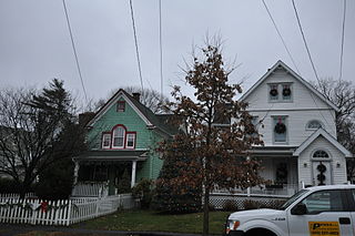
The Laurel Hill Historic District is a predominantly residential historic district south of downtown Norwich, Connecticut. The district was added to the National Register of Historic Places on October 26, 1987. It extends south from the Shetucket River along Laurel Hill Avenue, River Avenue, and Spruce Street. This area was developed as a residential district beginning in 1850, and includes a significant number of well-preserved Italianate and Gothic Revival houses.

The Greenwich Avenue Historic District is a historic district representing the commercial and civic historical development of the downtown area of the town of Greenwich, Connecticut. The district was listed on the National Register of Historic Places on August 31, 1989. Included in the district is the Greenwich Municipal Center Historic District, which was listed on the National Register the year before for the classical revival style municipal buildings in the core of Downtown. Most of the commercial buildings in the district fall into three broad styles, reflecting the period in which they were built: Italianate, Georgian Revival, and Commercial style. The district is linear and runs north–south along the entire length of Greenwich Avenue, the main thoroughfare of Downtown Greenwich, between U.S. Route 1 and the New Haven Line railroad tracks.
The Fourth Ward Historic District encompasses an early urban residential subdivision of Greenwich, Connecticut. Extending north from United States Route 1 along Sherwood Place, Church Street, and adjacent streets, it is one of two subdivisions created before the arrival of the railroad in Greenwich in 1848. It is characterized by dense residential construction, with architectural styles from the Greek Revival to early 20th-century styles. The district was listed on the National Register of Historic Places in 2000.

The Emory Place Historic District is a historic district in Knoxville, Tennessee, United States, located just north of the city's downtown area. The district consists of several commercial, residential, religious, and public buildings that developed around a late nineteenth century train and trolley station. The district includes the Knoxville High School building, St. John's Lutheran Church, First Christian Church, and some of the few surviving rowhouses in Knoxville. The district was listed on the National Register of Historic Places in 1994.

The Migeon Avenue Historic District encompasses a group of elegant residential properties on a one-block stretch of Migeon Avenue in Torrington, Connecticut. Consisting of five properties and four contributing primary buildings, this area was home to some of Torrington's leading businessmen at the turn of the 20th century. The houses are of high architectural quality, and original landscaping was done by the Olmsted Brothers landscape design firm. The district was listed on the National Register of Historic Places in 2002.

The Prospect Avenue Historic District encompasses a predominantly residential area in western Hartford and eastern West Hartford, Connecticut. The 300-acre (120 ha) historic district extends along Prospect Avenue from Albany Avenue to Fern Street, including most of the area between those streets and the Park River to the east, and Sycamore Street and Sycamore Lane to the west. The district includes 240 contributing buildings and 48 non-contributing buildings, most of them residences built between 1880 and 1930. The district was listed on the National Register of Historic Places in 1985.

The Prospect Park Second Plat Historic District is a nationally recognized historic district located in the north-central section of Des Moines, Iowa, United States. The residential area contained middle to upper class housing that was developed in the late 19th and early 20th centuries in the suburb of North Des Moines. It has been listed on the National Register of Historic Places since 1998. It is part of the Towards a Greater Des Moines MPS.
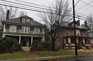
The Oxford-Whitney Streets District is a historic district encompassing an early-20th century residential area in the West End neighborhood of Hartford, Connecticut. It extends along the east side of Oxford Street between Elizabeth and Cone Streets, on the west side of Whitney between Fern and Elizabeth, and includes the north side of Fern Street between Whitney and Oxford. Most of the housing, a combination of single and multi-family residences, was built between 1906 and 1919, a period later than the surrounding areas, and is predominantly Colonial Revival in character. It was listed on the National Register of Historic Places in 2010.

The Palisado Avenue Historic District encompasses a predominantly residential streetscape in northeastern Windsor, Connecticut. Extending along Palisado Avenue between the Farmington River and Bissell Ferry Road, it is a basically 18th-century street view, populated mainly with houses from the 18th to the 20th centuries. The district was listed on the National Register of Historic Places in 1987.
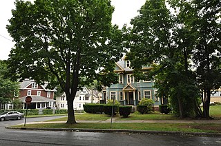
The Sisson-South Whitney Historic District encompasses a neighborhood in the West End area of Hartford, Connecticut, that was built out between 1890 and 1930 as a streetcar suburb. It is roughly bounded by Farmington Avenue, South Whitney Street, West Boulevard, and Sisson Avenue, and includes a diversity of residential and commercial architecture, reflective of its initial development and subsequent growth. The district was listed on the National Register of Historic Places in 2013.

The Morris Cove Historic District encompasses a former summer resort area in eastern New Haven, Connecticut. Bounded in the north by Myron Street, the south by Morris Causeway and Lighthouse Road, and on the east by the East Haven town line, the area was developed as a coastal summer community before being transformed into a streetcar suburb in the second quarter of the 20th century. It contains a high concentration of quality residential architecture from the first half of the century, and was listed on the National Register of Historic Places in 1985.

The Overlook Historic District encompasses a historic residential area north of downtown Waterbury, Connecticut. Roughly bounded by Calumet Street to the north, Columbia Avenue to the east, Cables Avenue and Tower Road to the south, and Willow an Fisk Streets to the west, it includes the city's finest concentration of turn-of-the century residential architecture, which was developed as its first major planned residential subdivision. The district was listed on the National Register of Historic Places in 1988.

Dudley St. Clair Donnelly (1870-1937) was an American architect practicing in New London, Connecticut in the late nineteenth and early twentieth centuries.


