The National Register of Historic Places (NRHP) is the United States federal government's official list of districts, sites, buildings, structures and objects deemed worthy of preservation for their historical significance. A property listed in the National Register, or located within a National Register Historic District, may qualify for tax incentives derived from the total value of expenses incurred in preserving the property.

Lolo National Forest is a national forest located in western Montana, United States with the western boundary being the state of Idaho. The forest spans 2 million acres (8,000 km2) and includes four wilderness areas; the Scapegoat and the Selway-Bitterroot Wilderness are partially within the forest while the Welcome Creek and Rattlesnake Wildernesses are solely in Lolo National Forest. The forest was created in 1906 from 4 different previous forests which were combined for administrative purposes. Lolo National Forest is west of the Continental divide and has a biodiversity influenced by both continental and maritime weather creating a transitional forest that has a high number of different plant and tree species.

This is intended to be a complete list of the properties and districts on the National Register of Historic Places in Fairfield County, Connecticut, United States. The locations of National Register properties and districts for which the latitude and longitude coordinates are included below may be seen in an online map.

The Selway River is a large tributary of the Middle Fork of the Clearwater River in the U.S. state of Idaho. It flows within the Selway-Bitterroot Wilderness, the Bitterroot National Forest, and the Nez Perce National Forest of North Central Idaho. The entire length of the Selway was included by the United States Congress in 1968 as part of the National Wild and Scenic Rivers Act.

The Boulder Bridge is a historic bridge located in the Washington, D.C. portion of Rock Creek Park, an urban national park listed on the National Register of Historic Places.
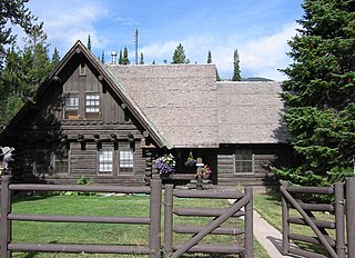
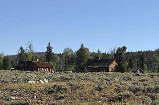
The Old Administrative Area Historic District, also known as Beaver Creek, is the former headquarters area of Grand Teton National Park. The complex of five houses, three warehouses and an administrative building were designed in the National Park Service rustic style between 1934 and 1939 and were built by the Civilian Conservation Corps and the Public Works Administration. As part of the Mission 66 program, the park headquarters were relocated to Moose, Wyoming in the 1960s.

Menor's Ferry was a river ferry that crossed the Snake River near the present-day Moose, Wyoming, United States. The site was homesteaded by Bill Menor in 1892-94, choosing a location where the river flowed in a single channel, rather than the braided stream that characterizes its course in most of Jackson Hole. During the 1890s it was the only homestead west of the river. Menor's homestead included a five-room cabin, a barn, a store, sheds and an icehouse on 148 acres (60 ha), irrigated by a ditch from Cottonwood Creek and at times supplemented by water raised from the Snake River by a waterwheel. Menor operated the ferry until 1918, selling to Maude Noble, who continued operations until 1927, when a bridge was built at Moose.

The Moose Entrance Kiosk was built between 1934 and 1939 by either the Public Works Administration or the Civilian Conservation Corps at the entrance to Grand Teton National Park. The log kiosk was built to National Park Service standard plans in the National Park Service Rustic style. It was originally located near the park's former administrative area, but was moved in the early 1960s to the new administration center and entrance at Moose. It is the last survivor of that building type and era in the park.

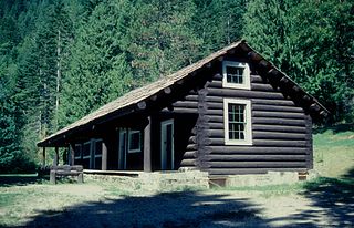
Moose Creek Ranger Cabin No. 19, also known as Moose Creek Patrol Cabin and Moose Creek Shelter Cabin, is a log shelter in the National Park Service Rustic style in Denali National Park. The cabin is part of a network of shelters for patrolling park rangers throughout the park. It is a standard design by the National Park Service Branch of Plans and Designs and was built in 1935. The cabin has five separate log dog kennels, also to a standard Park Service design, as well as an elevated food cache.
The historical buildings and structures of Grand Teton National Park include a variety of buildings and built remains that pre-date the establishment of Grand Teton National Park, together with facilities built by the National Park Service to serve park visitors. Many of these places and structures have been placed on the National Register of Historic Places. The pre-Park Service structures include homestead cabins from the earliest settlement of Jackson Hole, working ranches that once covered the valley floor, and dude ranches or guest ranches that catered to the tourist trade that grew up in the 1920s and 1930s, before the park was expanded to encompass nearly all of Jackson Hole. Many of these were incorporated into the park to serve as Park Service personnel housing, or were razed to restore the landscape to a natural appearance. Others continued to function as inholdings under a life estate in which their former owners could continue to use and occupy the property until their death. Other buildings, built in the mountains after the initial establishment of the park in 1929, or in the valley after the park was expanded in 1950, were built by the Park Service to serve park visitors, frequently employing the National Park Service Rustic style of design.
The Brush Creek Work Center in Medicine Bow National Forest near Saratoga, Wyoming is a ranger station of the USDA Forest Service, Region 2 that was built during 1937-41 and is listed on the National Register of Historic Places. It was designed by architects of the United States Forest Service in rustic style. The designs were applications of standard plans.
Sycamore Ranger Station, also known as Sycamore Work Center and as Sycamore Administrative Site, in Prescott National Forest near Camp Verde, Arizona was built in 1940 by the Civilian Conservation Corps. It was listed on the National Register of Historic Places in 1993 for its architecture, which includes vernacular, national(?), and other styles. It was designed by architects of the United States Forest Service. It served historically as institutional housing and as government office space. The NRHP listing included two contributing buildings on 2.5 acres (1.0 ha).
Architects of the National Park Service are the architects and landscape architects who were employed by the National Park Service (NPS) starting in 1918 to design buildings, structures, roads, trails and other features in the United States National Parks. Many of their works are listed on the National Register of Historic Places, and a number have also been designated as National Historic Landmarks.

Fenn Ranger Station is a U.S. Forest Service ranger station in the Nez Perce National Forest near Kooskia, Idaho. The ranger station serves as the headquarters of the Moose Creek Ranger District, which encompasses 870,000 acres (350,000 ha) of the forest. The Civilian Conservation Corps began building the ranger station in 1936 and finished the main administration building as well as two garages and two warehouses in 1937. Various other structures were added to the site in the next three years, with the last building, a barn, completed in 1940. The ranger station was added to the National Register of Historic Places on June 18, 1990.

The Ross Drive Bridge is a historic bridge located in the Washington, D.C. portion of Rock Creek Park, an urban national park listed on the National Register of Historic Places.

The Mantle Rock Archeological District, near Smithland, Kentucky is a 215 acres (0.87 km2) historic district which was listed on the National Register of Historic Places in 2004.
The Lochsa Historical Ranger Station, also known as Lochsa Ranger Station, near Kooskia, Idaho in Idaho County, Idaho, was built during 1927 to 1933. It served as administrative headquarters for the Lochsa Ranger District from 1922 to 1957. It was located within the Selway National Forest which was later merged into the Clearwater National Forest and the Nezperce National Forest. It was listed on the National Register of Historic Places in 1978.

The Covered Bridge Historic District, in Delaware Township, Hunterdon County, New Jersey, is a 97-acre (39 ha) historic district along County Route 604, Pine Hill Road, and Lower Creek Road. It was listed on the National Register of Historic Places on March 5, 1999, for its significance in architecture, settlement, and transportation. The listing included seven contributing buildings, two contributing structures, and three contributing sites.

