
Morrilton is a city in Conway County, Arkansas, United States, less than 50 miles (80 km) northwest of Little Rock. The city is the county seat of Conway County. The population was 6,992 at the 2020 United States census.

The Old Jeffersonville Historic District is located in Jeffersonville, Indiana, United States. It marks the original boundaries of Jeffersonville, and is the heart of modern-day downtown Jeffersonville. It was placed on the National Register of Historic Places in 1983. The area is roughly bounded by Court Avenue at the North, Graham Street on the east, the Ohio River at the south, and Interstate 65 at the west. In total, the district has 203 acres (0.8 km2), 500 buildings, 6 structures, and 11 objects. Several banks are located in the historic buildings in the district. The now defunct Steamboat Days Festival, held on the second weekend in September, used to be held on Spring Street and the waterfront. Jeffersonville's largest fire wiped out a block in the historic district on January 11, 2004, which destroyed the original Horner's Novelty store.

U.S. Route 64 is a U.S. route running from Teec Nos Pos, Arizona east to Nags Head, North Carolina. In the U.S. state of Arkansas, the route runs 246.35 miles (396.46 km) from the Oklahoma border in Fort Smith east to the Tennessee border in Memphis. The route passes through several cities and towns, including Fort Smith, Clarksville, Russellville, Conway, Searcy, and West Memphis. US 64 runs parallel to Interstate 40 (I-40) until Conway, when I-40 takes a more southerly route.
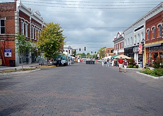
The Rogers Commercial Historic District, known informally as Historic Downtown Rogers, is a historic district in the central business district of Rogers, Arkansas. When it was first listed on the National Register of Historic Places in 1988, it was known as the Walnut Street Historic District; this was changed when the district was enlarged in 1993. The district encompasses a portion of the city's central business district, whose historical significance extends from about 1885 to the end of World War II.

The Argenta Historic District encompasses significant historic elements of central North Little Rock, Arkansas. The area that is now central North Little Rock was known as Argenta when it was first settled, and remained unincorporated until it was annexed to Little Rock in 1890. William Faucette, a leading Argenta politician and businessman, orchestrated the incorporation of North Little Rock just beyond the annexed area in 1901, and then made a successful petition to separate Argenta from Little Rock into the new municipality in 1903. Subsequent attempts to rename North Little Rock to Argenta have failed.
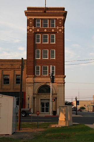
The First National Bank of Morrilton is a historic commercial building at Broadway and Moose Streets in Morrilton, Arkansas. It is a narrow five-story masonry building, occupying a prominent location at the city's main downtown intersection. It was built in 1925 to a design by architect Charles L. Thompson, and has Classical Revival and Bungalow/Craftsman features. The short Broadway Street facade features a recessed entrance with Classical features, while the upper floors are relatively unadorned red brick, with Craftsman motifs in tile around the top floor windows.
The Lake Village Commercial Historic District encompasses the historic commercial heart of Lake Village, Arkansas, the county seat of Chicot County in the Mississippi River delta region of southeastern Arkansas. The district covers about six square blocks of downtown Lake Village, bounded roughly by Jackson Street to the north, Lakeshore Drive to the east, Church Street to the south, and Chicot Street to the west. This area represents the growth of Lake Village during its period of greatest prosperity, between 1906 and 1960. The city's growth was spurred by the arrival of the railroad in 1903, and most of the district's buildings were built between 1900 and 1930. Most of the buildings are vernacular commercial buildings; the John Tushek Building at 202 Main Street is one interesting example of Beaux Arts styling, and 218–222 Main Street has some Italianate styling. The district includes the Lake Village Confederate Monument, which has been a local landmark since 1910.

The Fordyce Commercial Historic District encompasses the historic heart of Fordyce, Arkansas, the county seat of Dallas County. It encompasses four city blocks of North Main Street, between 1st and 4th, and includes properties on these adjacent streets. Fordyce was founded in 1882, and the oldest building in the district, the Nutt-Trussell Building at 202 North Main Street, was built c. 1884. Spurred by the logging industry and the Cotton Belt Railroad, Fordyce's downtown area had 25 buildings by 1901, and continued to grow over the next few decades, resulting in a concentration of period commercial architecture in its downtown. The district was listed on the National Register of Historic Places in 2008.
The Prescott Commercial Historic District encompasses the historic commercial core of Prescott, Arkansas, the county seat of Nevada County. Prescott was laid out in 1873, after the railroad was built through the area that is now Nevada County, and the railroad has played a significant role in the city's development. The railroad today bisects the commercial core of the city, which extends for several city blocks away from the railroad. The historic district includes all of the major civic buildings of the city, including the courthouse, post office, and the old Prescott City Jail.

The Hope Historic Commercial District encompasses a two-block area of downtown Hope, Arkansas. The 18-acre (7.3 ha) district is bounded on the north by the railroad tracks, on the east by Walnut Street, the west by Elm Street, and the south by 3rd Street. The area consists for the most part of commercial brick buildings one or two stories in height, with relatively plain styling. Most of these were built between 1880 and 1945, the major period of Hope's development. The most architecturally significant buildings in the district are the Brundidge Building, an 1893 Romanesque Revival structure, and the Renaissance Revival former post office building.

The East Broad Street Historic District encompasses a city block of historic commercial buildings in Texarkana, Arkansas. The district includes all of the buildings on the 100 block of East Broad Street. Most of the fifteen buildings in the district were built before 1920, during Texarkana's major period of growth after the arrival of the railroad. Broad Street, just one block from the railroad, quickly became its economic center. The oldest building is the O'Dwyer and Ahern Building at 110 East Broad Street, a three-story brick-faced building constructed c. 1886.

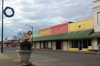
The Nashville Commercial Historic District encompasses much of the historic downtown commercial area of Nashville, Arkansas, and the major commercial center in Howard County. It is centered at the junction of Main and Howard Streets, extending eastward along East Howard, and north and south along Main Street for about one block. Most of the buildings in the district are tall single-story brick structures, some covered in stucco. They were built between about 1895 and the 1930s, with a smaller number appearing later. The area's economic activity was driven first by the arrival of the railroad, which defined the layout of the town, and then by the growth of lumber and agriculture in the region. The oldest building in the district is 203 North Main, built c. 1895 with modest Romanesque Revival styling.

The Marked Tree Commercial Historic District encompasses the historic commercial center of Marked Tree, Arkansas. It includes one city block of Frisco Street, between Nathan and Elm Streets, as well as two adjoining buildings on Elm Street. This area was developed commercially beginning with the arrival of the railroad in the 1880s, and was focused around the railroad depot, which no longer stands. All of the fifteen buildings in the district were built between 1910 and 1937, and exhibit typical early 20th-century commercial architecture, mostly executed in brick.
The Pocahontas Commercial Historic District encompasses the historic civic heart of Pocahontas, the county seat of Randolph County, Arkansas. The district includes roughly five-block stretches of Broadway and Pyburn and Everett Streets between US 67 and Bryant Street, and extends across US 67 to include a small complex of industrial buildings and the former railroad depot. Founded in 1836, the center of Pocahontas is dominated by the Old Randolph County Courthouse, a handsome Italianate structure built in 1875 which now houses city offices. It is surrounded by commercial buildings, generally one or two stories in height, most of which were built between 1900 and 1930, although there are a few 19th-century buildings. Later growth extended away from this center. Other notable buildings in the district include the present Randolph County Courthouse and the 1930s Art Deco style Post Office building.

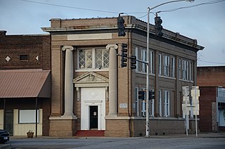
The Siloam Springs Downtown Historic District encompasses the historic downtown area of Siloam Springs, Arkansas. The district is roughly bounded by University Street, Broadway, and Sager Creek, with a few buildings on adjacent streets outside this triangular area. This business district was developed mainly between about 1896, when the railroad arrived, and 1940, and contains a significant number of buildings dating to that period. It also includes Siloam Springs City Park, the location of the springs that gave the city its name. Notable buildings include the First National Bank building, a c. 1890 Romanesque Revival building, and the c. 1881 Lakeside Hotel, which is one of the city's oldest commercial buildings.
The Hartford Commercial Historic District encompasses about two blocks of buildings in the central business district of Hartford, Arkansas. Extending on the east side of Broadway from just north of Main Street to south of Ludlow Street, they are the only major commercial buildings left from Hartford's boom years of 1880–1920, when coal in the area was mined for use by the railroads. Most of the buildings are single-story brick structures, in typical early-20th-century commercial styles. Included in the district is Hartford's present city hall, which was built in 1910 as a theater.
The Ozark Courthouse Square Historic District encompasses the historic late 19th-century center of Ozark, Arkansas. It includes an area two blocks by two blocks in area, bounded on the west by 4th Street, the north by West Commercial Street, the east by 2nd Street, and the south by West Main Street. Most of the buildings in the district were built between about 1890 and 1930, a period of significant growth occasioned by the arrival of the railroad, and are built either out of brick or locally quarried stone. Prominent buildings include the Franklin County Courthouse and the Bristow Hotel.

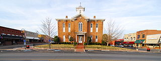
The former Morrilton station is located on Railroad Avenue, between Division and Moose Streets, in downtown Morrilton, Arkansas. It is a single-story brick building, with a tile roof and Mediterranean styling typical of the stations of the Missouri Pacific Railroad. The broadly overhanging roof is supported by large brackets, with a telegrapher's bay projecting on the track side. Built about 1907, it is an important reminder of the railroad's importance in the city's history. It now houses a local history museum.

The Moose Addition Neighborhood Historic District encompasses the oldest residential area of Morrilton, Arkansas. This area was farmland until the railroad was built through the region in the 1880s. Located just south of the railroad and the city's business district, this area was soon built up as a residential area, with most of its development coming between roughly 1925 and 1960. There is a single Queen Anne Victorian, built in 1881, from the earliest days of its development.

The Booneville Commercial Historic District encompasses the early 20th-century commercial heart of Booneville, Arkansas. Located on the east side of the 100 and 200 blocks of North Broadway Avenue are line with commercial buildings, most of which were built between about 1900 and 1920. The city had originally been located south of this location, but was relocated beginning in 1899 due to the arrival of the railroad joining Little Rock, Arkansas and McAlester, Oklahoma. Most of the buildings are in typical early 20th century vernacular commercial styling.


