
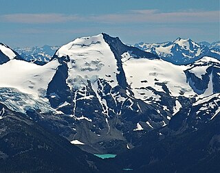
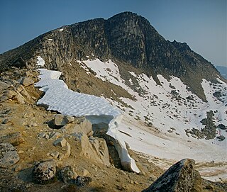
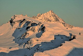
Mount Sedgwick is a prominent 2,082-metre (6,831-foot) mountain summit located in the Tantalus Range of southwestern British Columbia, Canada. It is situated 13 km (8 mi) west-northwest of Squamish, and 8 km (5 mi) south of Mount Tantalus, which is the highest peak in the Tantalus Range. Its nearest higher peak is The Red Tusk, 4.4 km (3 mi) to the northeast. Precipitation runoff from the peak drains west into tributaries of the Clowhom River, and east into Mill Creek which empties into Howe Sound. The first ascent of the mountain was made in 1909 by H. Dowler. The mountain is named for Adam Sedgwick (1785–1873), one of the founders of modern geology who accompanied Sir Roderick Murchison on geological tours in Canada. The mountain's name was officially adopted on May 3, 1951, by the Geographical Names Board of Canada.

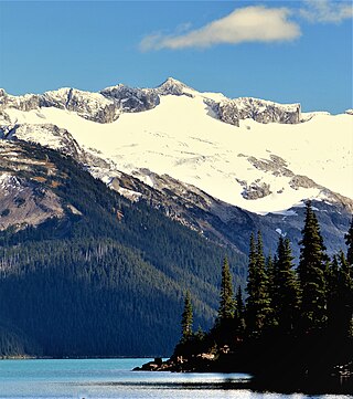
Joffre Peak is a 2,721-metre (8,927-foot) mountain summit located in the Coast Mountains, in Joffre Lakes Provincial Park, in southwestern British Columbia, Canada. It is the second-highest point of the Joffre Group, which is a subset of the Lillooet Ranges. It is situated 26 km (16 mi) east of Pemberton and 11 km (7 mi) northeast of Lillooet Lake. Joffre is more notable for its steep rise above local terrain than for its absolute elevation as topographic relief is significant with the summit rising 1,500 meters (4,920 ft) above Cayoosh Creek in 4 km (2.5 mi). The nearest higher peak is Mount Matier, 1.6 km (1 mi) to the south. The mountain's climate supports the Matier Glacier on the southwest slope, and the Anniversary Glacier on the southeast slope. Precipitation runoff from the peak drains into Joffre Creek and Cayoosh Creek which are both within the Fraser River watershed.
Slalok Mountain, originally known as Rex's Pillar, is a 2,653-metre (8,704-foot) mountain summit located in the Coast Mountains, in Joffre Lakes Provincial Park, in southwestern British Columbia, Canada. It is the third-highest point of the Joffre Group, which is a subset of the Lillooet Ranges. It is situated 24 km (15 mi) east of Pemberton, and 8 km (5 mi) northeast of Lillooet Lake. It is 4 km (2 mi) northeast of Duffey Peak and the nearest higher peak is Mount Matier, 1.9 km (1 mi) to the east. Precipitation runoff from the peak drains into Joffre Creek and Twin One Creek, both tributaries of the Lillooet River. The first ascent of the mountain was made in 1963 by C. Adam, T. Anderson, and G. Richardson. The mountain's name Slalok is the traditional name for the settlement of nearby Mount Currie. The name was officially adopted on June 11, 1979, by the Geographical Names Board of Canada. The mountain and its climate supports the Matier Glacier, Stonecrop Glacier, and Tszil Glacier on the northern slopes.
Mount Spetch is a 2,579-metre (8,461-foot) mountain summit located in the Coast Mountains, in Joffre Lakes Provincial Park, in southwestern British Columbia, Canada. It is part of the Joffre Group, which is a subset of the Lillooet Ranges. It is situated 25 km (16 mi) east of Pemberton, midway between Mount Matier and Slalok Mountain, both one kilometre either side of Spetch. The mountain's name was submitted by Karl Ricker of the Alpine Club of Canada to honor Samuel W. Spetch, who operated the general store at Birken, and other businesses in Pemberton. The name was officially adopted on January 23, 1979, by the Geographical Names Board of Canada. The first ascent of the mountain was made in 1971 by J. Oswald and G. Walter. Precipitation runoff from the peak drains into Joffre Creek and Twin One Creek, both tributaries of the Lillooet River. The mountain and its climate supports the Matier Glacier on the northern slope.

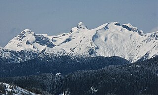
Mount Fitzsimmons is a 2,603-metre (8,540-foot) glacier-clad peak located in the Garibaldi Ranges of the Coast Mountains, in Garibaldi Provincial Park of southwestern British Columbia, Canada. It is the third-highest point of the Fitzsimmons Range, which is a subset of the Garibaldi Ranges. It is situated 15 km (9 mi) southeast of Whistler, and its nearest higher peak is Mount Benvolio, 0.5 km (0 mi) to the west-southwest. The Diavolo Glacier spreads out below the southeast aspect of the summit, and the Fitzsimmons Glacier descends the northwest slopes. Precipitation runoff from the peak and meltwater from its glaciers drains into tributaries of the Cheakamus River. The first ascent of the mountain was made on August 19, 1924, by a party of the British Columbia Mountaineering Club. The peak was named for prospector James Fitzsimmons, who built a trail along Fitzsimmons Creek in an effort to haul supplies to a small copper mine he staked and worked. The mountain's name was officially adopted on September 2, 1930, by the Geographical Names Board of Canada.
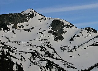
Mount Macbeth is a 2,639-metre (8,658-foot) glacier-clad peak located in the Garibaldi Ranges of the Coast Mountains, in Garibaldi Provincial Park of southwestern British Columbia, Canada. It is part of the Spearhead Range, which is a subset of the Garibaldi Ranges. It is situated 14 km (9 mi) southeast of Whistler, and 2 km (1 mi) south of Tremor Mountain, which is the highest point in the Spearhead Range. The Naden Glacier spreads out below the eastern aspect of the summit, the Macbeth Glacier lies below the south aspect, and the Curtain Glacier descends the northern slope. Precipitation runoff from the peak and meltwater from its glaciers drains into Fitzsimmons Creek which is a tributary of the Cheakamus River. Macbeth is most often climbed as part of the Spearhead Traverse. The first ascent of the mountain was made in 1969 by P. Starr, E. Bass, B. Ellis, and P. Macec via the northeast ridge. The peak was named in 1964 by an Alpine Club of Canada climbing party, to commemorate the 400th anniversary of William Shakespeare's birth. The mountain's name was officially adopted on August 27, 1965, by the Geographical Names Board of Canada.

Pelion Mountain is a 2,312-metre (7,585-foot) summit located in the Tantalus Range, in Tantalus Provincial Park, in southwestern British Columbia, Canada. It is situated 21 km (13 mi) northwest of Squamish, 0.8 km (0 mi) east of Ossa Mountain, and 5.5 km (3 mi) north-northwest of Mount Tantalus, which is its nearest higher peak and the highest peak in the Tantalus Range. Unnamed glaciers surround the peak and precipitation runoff from the peak drains into tributaries of the Squamish River and Clowhom River. The first ascent of the mountain was made in 1944 by V. Brink and B. McLellan. The mountain names in the Tantalus Range have a Greek mythology theme, and Pelion Mountain was named for the legendary Pelion mountain in Thessaly, upon which the Aloadaes are said to have attempted to pile Mount Pelion on top of Mount Ossa in their attempt to scale Olympus, home of the Greek gods. The mountain's name was officially adopted on June 6, 1957, by the Geographical Names Board of Canada.
Mount Gandalf is a 2,391-metre (7,844-foot) mountain summit in the Cadwallader Range in southwestern British Columbia, Canada. It is at the northeast corner of Birkenhead Lake Provincial Park, 35 km (22 mi) north of Pemberton, 56 km (35 mi) west of Lillooet, 2.9 km (2 mi) north of Tolkien Peak, and immediately south of Mount Aragorn, which is its nearest higher peak. Precipitation runoff from the peak drains into tributaries of the Fraser River.
Mount Aragorn is a 2,435-metre (7,989-foot) mountain summit located in the Cadwallader Range in southwestern British Columbia, Canada. It is situated 36 km (22 mi) north of Pemberton, 56 km (35 mi) west of Lillooet, and immediately north of Mount Gandalf. Precipitation runoff from the peak drains into tributaries of the Fraser River.

Mount Sampson is a 2,811-metre (9,222-foot) mountain summit located in the Thiassi Range of the Coast Mountains, in the Pemberton Valley of southwestern British Columbia, Canada. It is the highest point in the Thiassi Range. Sampson is situated 41 km (25 mi) northwest of Pemberton, and 21.5 km (13 mi) southeast of Mount Ethelweard, which is its nearest higher peak. Precipitation runoff from the peak drains into tributaries of the Lillooet and Hurley Rivers.
Mount Thiassi is a 2,772-metre (9,094-foot) mountain summit located in the Thiassi Range of the Coast Mountains, in southwestern British Columbia, Canada. It is the third-highest point in the Thiassi Range. Mount Thiassi is situated 56 km (35 mi) northwest of Pemberton, and 6.9 km (4 mi) south-southwest of Mount Vayu, which is its nearest higher peak. Precipitation runoff from the peak and meltwater from unnamed glaciers on its slopes drain into tributaries of the Lillooet, Bridge, and Hurley Rivers. The first ascent of the mountain was made in 1965 by Dick Culbert and Alice Purdey. The mountain's name was submitted by this first ascent party to commemorate Thiassi, the god of storms according to Norse mythology. The name was officially adopted June 22, 1967, by the Geographical Names Board of Canada.

Tolkien Peak is a 2,380-metre (7,810-foot) mountain summit located in the Cadwallader Range in southwestern British Columbia, Canada. It is situated in Birkenhead Lake Provincial Park, 32 km (20 mi) north of Pemberton, and 2.9 km (2 mi) south of Mount Gandalf, which is its nearest higher peak. The peak is named for J. R. R. Tolkien (1892–1973), author of the novels The Hobbit and The Lord of the Rings. The names for nearby Mount Aragorn, Mount Gandalf, and Mount Shadowfax were taken from fictional characters in his books, which were read while waiting out stormy weather during the 1972 first ascents of those mountains. Precipitation runoff from the peak drains into tributaries of the Fraser River.
Mount Tinniswood is a 2,606-metre (8,550-foot) mountain summit located in British Columbia, Canada.
Mount Trorey is a 2,461-metre (8,074-foot) mountain summit located in British Columbia, Canada.
Mount James Turner is a 2,703-metre (8,868-foot) mountain summit located in British Columbia, Canada.
Mount Carr is a 2,590-metre (8,497-foot) mountain summit located in British Columbia, Canada.

Ipsoot Mountain is a 2,576-metre (8,451-foot) glaciated summit located in southwest British Columbia, Canada.
Stonerabbit Peak is a 1,857-metre (6,093-foot) mountain summit located in British Columbia, Canada.

Mount Ronayne is a 2,290-metre (7,513-foot) summit located in the Pemberton Valley of British Columbia, Canada.
Vantage Peak is a 2,235-metre (7,333-foot) mountain summit located in the Coast Mountains of British Columbia, Canada. It is part of the Joffre Group, which is a subset of the Lillooet Ranges. It is situated 28.5 km (18 mi) east of Pemberton on the boundary of the Nlháxten/Cerise Creek Conservancy. Precipitation runoff from the peak drains southwest into Twin One Creek thence Lillooet Lake; the north slope drains into headwaters of Cerise Creek; and the east slope drains into Caspar Creek thence Cayoosh Creek which is within the Fraser River watershed. Vantage Peak is more notable for its steep rise above local terrain than for its absolute elevation as topographic relief is significant with the summit rising 1,135 meters (3,724 ft) above Twin One Creek in 4 km (2.5 mi). The nearest higher neighbor is Mount Duke, 2.08 km (1 mi) to the southeast.


