
Mount Tabor is a town in Rutland County, Vermont, United States. The population was 255 at the 2010 census.
Mount Tabor may refer to:
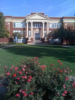
Tabor College is a four-year private Christian liberal arts college in Hillsboro, Kansas, United States. Tabor is currently owned and operated by the Mennonite Brethren Church and adheres to Anabaptist doctrine. There were 594 students enrolled at the Tabor College Hillsboro campus for the Fall 2014 semester. Total enrollment, including the Tabor College School of Adult and Graduate Studies in Wichita was 766.

Mount Tabor is the name of a volcanic cinder cone, the city park on the volcano, and the neighborhood of Southeast Portland that surrounds it, all in the U.S. state of Oregon. The name refers to Mount Tabor, Israel. It was named by Plympton Kelly, son of Oregon City pioneer resident Clinton Kelly.

Mount Tabor is a New Jersey Transit station in Denville, New Jersey along the Morristown Line just west of the small community of Mount Tabor in Parsippany-Troy Hills, New Jersey. The station consists of one side platform and 48 parking spaces for commuters. One of these parking spaces is handicapped-accessible. The station sees limited service on a daily basis.

Mount Tabor is an unincorporated community that was founded as a Methodist camp meeting in what is now Parsippany-Troy Hills, in Morris County, New Jersey, United States.
North Tabor Neighborhood in Portland, Oregon, United States, is on the east side of the Willamette River on the northern slope of Mount Tabor. The Banfield Expressway forms its northern boundary, separating it from the Hollywood District, Rose City Park, and Madison South neighborhoods to the north. NE/SE 44th Ave. separates it from Laurelhurst to the west and NE 68th Ave. from Montavilla to the east. East Burnside Street forms most of the southern boundary, except for a section west of SE 49th Ave. for which SE Stark Street forms the boundary with the Sunnyside neighborhood.
South Tabor is a neighborhood in southeastern Portland, Oregon in the United States. The neighborhood is bounded by SE Division, Powell, 52nd, and 82nd Avenues. Its neighborhood association is a member of the Southeast Uplift coalition, which serves as its link to Portland's Office of Neighborhood Involvement.

Mount Tabor is an extinct or dormant volcanic vent, the city park on the volcano, and the neighborhood of Southeast Portland, Oregon that surrounds it. The name refers to Mount Tabor, Israel. It was named by Plympton Kelly, son of Oregon City pioneer resident Clinton Kelly.

Mount Tabor is located in Lower Galilee, Israel, at the eastern end of the Jezreel Valley, 11 miles (18 km) west of the Sea of Galilee.

Mount Tabor is an unincorporated community in Bean Blossom Township, Monroe County, in the U.S. state of Indiana.
Crown Center is an unincorporated community in Adams Township, Morgan County, in the U.S. state of Indiana.

Sabin is an unincorporated community in the Town of Sylvan, Richland County, Wisconsin, United States. It is located at the intersection of County Highway E and Robbson Drive.

Mount Tabor is an unincorporated community in Adams County, Pennsylvania, United States. Mount Tabor is located in Menallen Township off Pennsylvania Route 34 and is about 2 miles (3 km) west of Idaville.
Mount Tabor is a neighborhood in southeastern Lexington, Kentucky, United States. Its boundaries are Alumni Drive to the west, New Circle Road to the north, Richmond Road to the east, and Man o' War Boulevard to the South.
John Tabor Kingston Jr. was a member of the Wisconsin State Senate during the 1891 and 1893 sessions.

The Mount Tabor Indian Community is a state-recognized tribe made up of primarily Cherokees as well as Choctaw, Chickasaw and Muscogee-Creek Indians located in Rusk County, Texas. They are descended from Cherokee who migrated to Texas prior to the Cherokee War of 1839 under Duwa'li or The Bowl. They sought refuge in Monclova, Mexico after 1840, when the Republic of Texas was trying to expel Indians from East Texas. Led by Chicken Trotter, also known as Devereaux Jarrett Bell, the group fought a guerilla campaign against the Republic of Texas from Mexico throughout 1840 to 1842.


