The Krishna River in the Deccan plateau is the third-longest river in India, after the Ganges and Godavari. It is also the fourth-largest in terms of water inflows and river basin area in India, after the Ganges, Indus and Godavari. The river, also called Krishnaveni, is 1,400 kilometres (870 mi) long and its length in Maharashtra is 282 kilometres. It is a major source of irrigation in the Indian states of Maharashtra, Karnataka, Telangana and Andhra Pradesh.

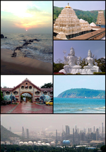
Visakhapatnam is the largest and most populous metropolitan city in the Indian state of Andhra Pradesh. It is between the Eastern Ghats and the coast of the Bay of Bengal. It is the second largest city on the east coast of India after Chennai, and the fourth largest in South India. It is one of the four smart cities of Andhra Pradesh selected under the Smart Cities Mission and is the headquarters of Visakhapatnam district. With an estimated output of $43.5 billion, it is the ninth largest contributor to India's gross domestic product as of 2016.

Coastal Andhra or Kosta Andhra is a geographic region in the Indian state of Andhra Pradesh. Vijayawada is the largest city in this region followed by Guntur. The region share borders with Rayalaseema region of the state and Telangana. It was a part of Madras State before 1953 and Andhra State from 1953 to 1956. According to the 2011 census, it has an area of 91,915 square kilometres (35,489 sq mi) which is 57.99% of the total state area and a population of 34,193,868 which is 69.20% of Andhra Pradesh state population. This area includes the coastal districts of Andhra Pradesh on the Circar Coast between the Eastern Ghats and the Bay of Bengal, from the northern border with Odisha to Rayalaseema in the south.

Velikkakathu Sankaran Achuthanandan, popularly known by his initials V. S., is an Indian politician who was the Chief Minister of Kerala from 2006 to 2011. At 82, he was the oldest person to have assumed the office. He is affiliated to the Communist Party of India (Marxist). He served as the chairman of Administrative reforms in Kerala with state cabinet rank from 2016 to 2021. He has served as Leader of the Opposition for 15 years which makes him the longest serving Leader of the Opposition in Kerala Legislative Assembly.

Krishna Raja Sagara, also popularly known as KRS, is a lake and the dam that creates it. They are close to the settlement of Krishna Raja Sagara in the Indian State of Karnataka. The gravity dam made of surki mortar is below the confluence of river Kaveri with its tributaries Hemavati and Lakshmana Tirtha, in the district of Mandya.

Nagarjuna Sagar Dam is a masonry dam across the Krishna River at Nagarjuna Sagar which straddles the border between Palnadu district in Andhra Pradesh and Nalgonda district in Telangana. The dam provides irrigation water to the districts of Krishna, Guntur, Palnadu, Prakasam and parts of West Godavari districts of Andhra Pradesh and also Nalgonda, Suryapet, Khammam, Bhadradri Kothagudem districts of Telangana. It is also a source of electricity generation for the national grid.

Bade Bacheli is a town and a Nagar Palika in Dantewada district in the state of Chhattisgarh, India. It is now very well known as NMDC Township with nature all around to explore and witness. It is situated roughly 400 km from Raipur, capital of Chhattisgarh. The way to travel is by Road with frequent bus service from Raipur, Bhilai, Jagdalpur, and Hyderabad, Visakhapatnam or by train from Jagdalpur and Vishakhapatnam.
Tawa Reservoir is a reservoir on the Tawa River in central India. It is located in Itarsi of Narmadapuram District of Madhya Pradesh state, above Betul district. The reservoir was formed by the construction of the Tawa Dam, which began in 1958 and was completed in 1978. The dam provides for irrigation to several thousand hectares of farming land in Narmadapuram and Harda districts. It is also a big tourist attraction during the monsoon months. It was designated as a Ramsar site of national importance in 2024.

The Gosthani river is a river in India. It rises in the Ananthagiri Hills of the Eastern Ghats and flows through the Borra Caves which lie near its source. It is the largest river flowing through Visakhapatnam city. It flows for 120 km before joining the Bay of Bengal through an estuary near Bheemunipatnam. The river basin drains the two coastal districts of Vizianagaram and Visakhapatnam. The basin exhibits a subdendritic and dendritic pattern of drainage. The Gosthani's is a minor river basin with a total drainage area of less than 2000 km2. Much of the basin is covered by khondalite group of gneissic rocks. About 3% of the total area of the Visakhapatnam district is under the Gosthani basin. The river is rainfed, receiving an average rainfall of 110 cm most of which comes from the south-west monsoon. There are several red sand hills near Bheemunipatnam, where the Gosthani joins the Bay of Bengal, which are reminiscent of the Chambal ravines. These are thought to have been formed six millennia ago due to shifts in the river's course following tectonic activity. The river joins the Bay of Bengal at Bhimli where it forms an estuary.

The Polavaram Project is an under construction multi-purpose irrigation project on the Godavari River in the Eluru District and East Godavari District in Andhra Pradesh. The project has been accorded National project status by the Central Government of India. Its reservoir back water spreads up to the Dummugudem Anicut and approx 115 km on Sabari River side. Thus back water spreads into parts of Chhattisgarh and Odisha States. It gives major boost to tourism sector in Godavari Districts as the reservoir covers the famous Papikonda National Park, Polavaram hydro electric project (HEP) and National Waterway 4 are under construction on left side of the river. It is located 40 km to the upstream of Sir Arthur Cotton Barrage in Rajamahendravaram City and 25 km from Rajahmundry Airport.

The Pulichintala Project is a multi-purpose water management project for irrigation, hydropower generation, and flood control in the state of Andhra Pradesh, India, named after the prominent civil engineer, Kanuri Lakshmana Rao. It is a crucial irrigation facility for farmers in four coastal districts: West Godavari, Krishna, Guntur, Palanadu, and Prakasam, covering over 13 lakh acres. It has 24 gates and a balancing reservoir with a capacity of 46 Tmcft at 175 feet (53 m) MSL full reservoir level (FRL).

"Tatipudi Reservoir" is a dam located on River Gosthani in Andhra Pradesh. It is a water supply reservoir to the city of Visakhapatnam. Thatipudi Reservoir Project was constructed across Gosthani River during 1963–1968. The Project is aimed to irrigate a total ayacut of 15,378 acres (62 km2) in Vizianagaram District and to provide drinking water to Visakhapatnam City. The Project utilizes 3.325 tmcft of the available water and the reservoir storage capacity is about 3 tmcft. The Cost of the project is Rs. 1,820 crores. The Ayacut of 15,378 acres (62 km2) has been stabilised in Gantyada, S.Kota and Jami Mandals of Vizianagaram District.
The coastal city of Chennai has a metropolitan population of 10.6 million as per 2019 census. As the city lacks a perennial water source, catering the water requirements of the population has remained an arduous task. On 18 June 2019, the city's reservoirs ran dry, leaving the city in severe crisis.
Kailasagiri is a hilltop park in the city of Visakhapatnam in the Indian state of Andhra Pradesh. The park was developed by the Visakhapatnam Metropolitan Region Development Authority (VMRDA) and comprises 380 acres (150 ha) of land covered with flora and tropical trees. The hill, at 173 metres (568 ft), overlooks the city of Visakhapatnam.
Alluri Sitarama Raju International Airport is an international airport and a greenfield airport under construction at Bhogapuram in the Visakhapatnam Metropolitan Region. The airport is operated by GMR Visakhapatnam International Airport Limited. The airport is named after Indian Independence revolutionary and freedom fighter Alluri Sitarama Raju.

Meghadri Gedda Reservoir, officially "Sri Dronam Raju Satyanarayana Reservoir Scheme" is a reservoir and dam in Visakhapatnam, India. It is one of the main water sources of the Visakhapatnam city. It's capacity is 11 MGD and it is maintained by Greater Visakhapatnam Municipal Corporation.

Sri Varada Narayana Murty Raiwada Reservoir Project or Raiwada Reservoir is a reservoir constructed across the Sarada River near Raiwada village, Devarapalli mandal, Anakapalli district, 58 km from Visakhapatnam city. It is one of the main water sources for Visakhapatnam city. Its capacity is 2,360 tcm, and it is maintained by Irrigation & CAD Dept.
The Kaleshwaram Lift Irrigation Project (KLIP) is a multi-purpose irrigation project on the Godavari River in Kaleshwaram, Bhupalpally, Telangana, India. Currently the world's largest multi-stage lift irrigation project, its farthest upstream influence is at the confluence of the Pranahita and Godavari rivers. The Pranahita River is itself a confluence of various smaller tributaries including the Wardha, Painganga, and Wainganga rivers which combine to form the seventh-largest drainage basin on the subcontinent, with an estimated annual discharge of more than 6,427,900 acre-feet (7,930 cubic hectometres) or 280 TMC. It remains untapped as its course is principally through dense forests and other ecologically sensitive zones such as wildlife sanctuaries.