Andhra Pradesh is a state in the south-eastern coastal region of India. It is the seventh-largest state by area covering an area of 162,975 km2 (62,925 sq mi) and tenth-most populous state with 49,386,799 inhabitants. It is bordered by Telangana to the north-west, Chhattisgarh to the north, Odisha to the north-east, Tamil Nadu to the south, Karnataka to the west and the Bay of Bengal to the east. It has the second longest coastline in India after Gujarat, of about 974 km (605 mi). Andhra State was the first state to be formed on a linguistic basis in India on 1 October 1953. On 1 November 1956, Andhra State was merged with the Telugu-speaking areas of the Hyderabad State to form United Andhra Pradesh. In 2014 these merged areas of Hyderabad State were bifurcated from United Andhra Pradesh to form the new state Telangana. The present form of Andhra is similar to Andhra state, but some mandalas like Bhadrachalam are still included in Telangana. Amaravati serves as the capital of present Andhra with the largest city being Visakhapatnam.

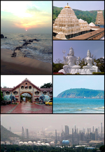
Visakhapatnam, also known as Vizag, Viśākha or Waltair, is the largest and most populous city in the Indian state of Andhra Pradesh. It is between the Eastern Ghats and the coast of the Bay of Bengal. It is the second-largest city on the east coast of India after Chennai, and the fourth-largest in South India. It is one of the four smart cities of Andhra Pradesh selected under the Smart Cities Mission and serves as the headquarters of Visakhapatnam district. With an estimated output of $43.5 billion, it is the ninth-largest contributor to India's gross domestic product as of 2016.
Vijayawada, formerly known as Bezawada, is the second largest city in the Indian state of Andhra Pradesh and is a part of the state's Capital Region. It is the administrative headquarters of the NTR district. Its metropolitan region comprises NTR and parts of Krishna and Guntur districts.Vijayawada lies on the banks of Krishna river surrounded by the hills of Eastern Ghats, known as Indrakeeladri Hills. It geographically lies on the center spot of Andhra Pradesh. The city has been described as the commercial, political, cultural and educational capital of Andhra Pradesh It is the second largest city in Andhra Pradesh with a population of 1,723,000 in 2021, estimated population of 1,991,189 in the Vijayawada Metropolitan Area. It is one of the fastest growing urban areas in India and among the top 10 fastest growing cities in the world according to Oxford Economics report.

Coastal Andhracoastal regions of Andhra Pradesh, also known as Kostha Andhra, is a region in the state of Andhra Pradesh, India. Visakhapatnam is the largest city in this region, while Vijayawada is the second largest city in the region.It was part of Madras State before 1953 and Andhra State from 1953 to 1956. According to the 2011 census, it has an area of 91,915 square kilometres (35,489 sq mi) which is 57.99% of the total state area and a population of 34,193,868 which is 69.20% of Andhra Pradesh state population. This area includes the coastal districts of Andhra Pradesh on the Circar Coast between the Eastern Ghats and the Bay of Bengal, from the northern border with Odisha in the South.
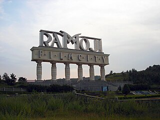
Ramoji Film City is an integrated film studio facility located in Hyderabad, India. Spread over 1,666 acres, it is the largest film studio complex in the world and as such has been certified by the Guinness World Records. It was established by Telugu media tycoon Ramoji Rao in 1996. The Guardian described Ramoji Film City as "city within a city."

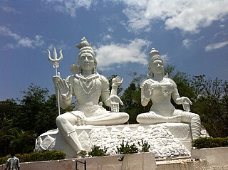
Andhra Pradesh is a state in India. Andhra Pradesh Tourism Development Corporation (APTDC) is a state government agency which promotes tourism in Andhra Pradesh, describing the state as the Koh-i-Noor of India. Andhra Pradesh has a variety of tourist attractions including beaches, hills, caves, wildlife, forests and temples.

Visakhapatnam Port is one of 13 major ports in India and the only major port of Andhra Pradesh. It is India's third largest state-owned port by volume of cargo handled and largest on the Eastern Coast. It is located midway between the Chennai and Kolkata Ports on the Bay of Bengal.
Visakhapatnam North Assembly constituency is a constituency in Vishakhapatnam district of Andhra Pradesh, representing the state legislative assembly in India. It is one of the seven assembly segments of Visakhapatnam, along with Bheemili, Visakhapatnam East, Visakhapatnam South, Visakhapatnam West and Gajuwaka. Ganta Srinivasa Rao is the present MLA of the constituency, who won the 2019 Andhra Pradesh Legislative Assembly election from Telugu Desam Party. As of 25 March 2019, there a total of 280,151 electors in the constituency.
Kailasagiri is a hilltop park in the city of Visakhapatnam in the Indian state of Andhra Pradesh. The park was developed by the Visakhapatnam Metropolitan Region Development Authority (VMRDA) and comprises 380 acres (150 ha) of land covered with flora and tropical trees. The hill, at 173 metres (568 ft), overlooks the city of Visakhapatnam.

Yarada Beach is situated on the east coast of Bay of Bengal in Yarada, a village at a distance of 15 kilometres (9.3 mi) from Visakhapatnam. It is located near Gangavaram beach, Dolphin's Nose, and Gangavaram Port. This is a very picturesque beach in Andhra Pradesh.
Transport in Visakhapatnam is the network of roads, railways, rapid transit system in the largest city of Andhra Pradesh. The city of Visakhapatnam also serves as the central hub of transport and logistics on the East coast of India and hence it is called as City Of Destiny.

Dolphin's Nose is a hill in Visakhapatnam between Yarada and Gangavaram Port. The hill is named Dolphin's Nose because it resembles a dolphin's nose. It is a conspicuous land mark in Visakhapatnam. Dolphin's nose is a huge rocky head land which is 174 meters high and 358 meters above sea level. The powerful beacon of the light house set on this rock at sea directs ships 65 km away.

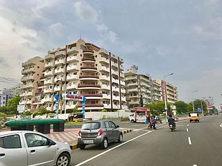
Lankelapalem is a neighbourhood in the city of Visakhapatnam, state of Andhra Pradesh, India. It is a suburb of the city.
Chinna Waltair is a coastal neighborhood in Visakhapatnam in the Indian state of Andhra Pradesh, 5km away from the city's central neighborhood, Dwaraka Nagar. The area is governed by the Greater Visakhapatnam Municipal Corporation. The neighborhood offers tourist attractions along the Beach Road highway, including the Visakha Museum of historical artifacts from the Uttarandhra region and the Victory at Sea Memorial dedicated to the Indian Navy.
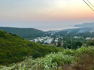
Yarada is a neighborhood situated on the Visakhapatnam City, India. It is famous for its beach and a hill road to reach the beach. It is one of the scarcely populated beaches in the city. The area, which falls under the local administrative limits of Greater Visakhapatnam Municipal Corporation and is well known for Yarada Beach. ..Yarada is a part in Gajuwaka Mandal.

The Visakhapatnam Metropolitan Region Development Authority (VMRDA) is the urban planning agency of Visakhapatnam in the Indian state of Andhra Pradesh. It was formed by expanding the existing Visakhapatnam Urban Development Authority (VUDA). The VMRDA administers the Visakhapatnam Metropolitan Region, spread over an area of 7,328.86 km2 (2,829.69 sq mi) and covers the districts of Visakhapatnam,Vizianagaram and Anakapalli. It was set up for the purposes of planning, co-ordination, supervising, promoting and securing the planned development of the Visakhapatnam Metropolitan Region. It coordinates the development activities of the municipal corporations, municipalities and other local authorities.
Chengal Rao Peta is one of the oldest settlements in the city of Visakhapatnam in the Indian state of Andhra Pradesh.The area, which falls under the local administrative limits of Greater Visakhapatnam Municipal Corporation, is about 4 km from the Dwaraka bus station.