Culture of Visakhapatnam

Last updated

Simhachalam Devasthanam Raja Gopuram Varaha Lakshmi Narasimha temple in Simhachalam.jpg
Simhachalam Devasthanam Raja Gopuram

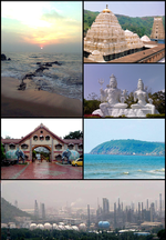
Visakhapatnam, also known as Vizag, is a city and port in the South India state of Andhra Pradesh. Visakhapatnam has long history since 1068 AD inscriptions of Sri Bheemeswara Swamy temple, 4th largest city in South India. [1]

Contents

Religion

Hinduism is the majority religion in this city with 93%, other religions are Islam, Christianity and Buddhism religious tolerance is very important in this city. [2]

People

replica at Telugu Samskruthika Niketanam Model of court in Sri Krishnadevaraya asthanam.jpg
replica at Telugu Samskruthika Niketanam

Majority of people in Visakhapatnam are Telugu because Visakhapatnam is the largest city in Andhra Pradesh. Along with that we can find Odia, Hindi, Tamil and Malayalam people also. Visakhapatnam has a cosmopolitan culture. English is also used widely in Vizag because significant amount of Anglo-Indian people lives here. [3]

Cuisine

in Visakhapatnam typical south Indian cuisine available its destination for Andhra food especially Muri Mixture, Idly, Dosa, Pesarattu, Kodi pulao and bamboo chicken are available as is western food such as pizza burgers. [4]

Festivals

Makar Sankranti is a festival in Vizag which celebrates Ugadi, Vinayaka Chavithi, Deepavali, Dasara. [5]

Sports

Cricket is the most popular game in Vizag. Kabaddi, tennis, badminton, and field hockey are also popular. Sports facilities include Dr. Y. S. Rajasekhara Reddy ACA–VDCA Cricket Stadium, Port Trust Diamond Jubilee Stadium, and Swarna Bharathi Indoor Stadium.

See also

Related Research Articles

<span class="mw-page-title-main">Andhra Pradesh</span> State in South India, India

Andhra Pradesh is a state in the southern coastal region of India. It is the seventh-largest state with area of 162,970 km2 (62,920 sq mi) and tenth-most-populous state, with 49,577,103 inhabitants. It has shared borders with Telangana, Chhattisgarh, Odisha, Tamil Nadu, Karnataka, and the Bay of Bengal. It has the second-longest coastline in India of about 974 km (605 mi). After existence as Andhra State and United Andhra Pradesh, the state took its present form on 2 June 2014, when the new state Telangana was formed. Amaravati serves as the capital of the state with the largest city being Visakhapatnam. Water sharing disputes and assets division with Telangana following the bifurcation in 2014 are not yet resolved. Telugu, one of the classical languages of India used by majority of people, is an official language.

<span class="mw-page-title-main">Visakhapatnam</span> Metropolis in Andhra Pradesh, India

Visakhapatnam, also known as Vizag, Viśākha or Waltair, is the largest and most populous city in the Indian state of Andhra Pradesh. It is between the Eastern Ghats and the coast of the Bay of Bengal. It is the second-largest city on the east coast of India after Chennai, and the fourth-largest in South India. It is one of the four smart cities of Andhra Pradesh selected under the Smart Cities Mission and is the headquarters of Visakhapatnam district. With an estimated output of $43.5 billion, it is the ninth-largest contributor to India's gross domestic product as of 2016.

<span class="mw-page-title-main">South India</span> Region in India

South India, also known as Peninsular India, consists of the peninsular southern part of India. It encompasses the Indian states of Andhra Pradesh, Karnataka, Kerala, Tamil Nadu, and Telangana, as well as the union territories of the Andaman and Nicobar Islands, Lakshadweep and Puducherry, comprising 19.31% of India's area and 20% of India's population. Covering the southern part of the peninsular Deccan Plateau, South India is bounded by the Bay of Bengal in the east, the Arabian Sea in the west and the Indian Ocean in the south. The geography of the region is diverse with two mountain ranges – the Western and Eastern Ghats – bordering the plateau heartland. The Godavari, Krishna, Kaveri, Tungabhadra, Periyar, Bharathappuzha, Pamba, Thamirabarani, Palar, and Vaigai rivers are important perennial rivers.

<span class="mw-page-title-main">Coastal Andhra</span> Geographic region of Andhra Pradesh in India

Coastal Andhra or Kosta Andhra is a geographic region in the Indian state of Andhra Pradesh. Vijayawada is the largest city in this region. Region share borders with Uttarandhra, Rayalaseema and Telangana. It was part of Madras State before 1953 and Andhra State from 1953 to 1956. According to the 2011 census, it has an area of 91,915 square kilometres (35,489 sq mi) which is 57.99% of the total state area and a population of 34,193,868 which is 69.20% of Andhra Pradesh state population. This area includes the coastal districts of Andhra Pradesh on the Circar Coast between the Eastern Ghats and the Bay of Bengal, from the northern border with Odisha to Rayalaseema in the south.

Kakinada is the sixth largest city of the Indian state of Andhra Pradesh and serves as the district headquarters of the Kakinada District. It lies on the coast of the Bay of Bengal. J.N.T.U. College of Engineering Kakinada, established in 1946, is the oldest and popular Government college in the state of Andhra Pradesh. The First Polytechnic college of Andhra Pradesh, Andhra Polytechnic was established here in 1946. It was also the origin point of Buckingham Canal where goods used to be transported by boats during the British rule. It was once home for Asia's largest sea port. Many people from the city migrated from this sea port to countries like Burma, Mauritius, Fiji and various southeast Asian countries to work there as workers where they were called as Coringas.

<span class="mw-page-title-main">Vizianagaram district</span> District of Andhra Pradesh in India

Vizianagaram district is one of the six districts in the Uttarandhra region of the Indian state of Andhra Pradesh with its headquarters located at Vizianagaram. The district was once the part of ancient Kalinga.Saripilli Dibbilingeswara temple, Jayathi Mallikarjuna Temple are the finest examples of ancient Eastern Ganga Dynasty built monuments in the district. The district is bounded on the east by the district of Srikakulam, north by Parvathipuram Manyam south by Visakhapatnam, Anakapalli, southeast by the Bay of Bengal, and west by Alluri Sitharama Raju district. It was formed on 1 June 1979, with some parts carved from the neighbouring districts of Srikakulam and Visakhapatnam. The district is named after the princely state of Vizianagaram. In 2011, it was the least populous district in Andhra Pradesh.

<span class="mw-page-title-main">Kadapa</span> City Corporation in Andhra Pradesh, India

Kadapa is a city in the southern part of Andhra Pradesh, India. It is located in the Rayalaseema region, and is the district headquarters of YSR Kadapa district. As of the 2022 Census of India, the city had a population of 466,000, a 2.42% increase from 2021. It is located 8 kilometres (5.0 mi) south of the Penna River. The city is surrounded on three sides by the Nallamala and Palkonda Hills lying on the tectonic landscape between the Eastern and Western ghats. Black and Red ferrous soils occupy the region. The city is nicknamed "Gadapa" ('threshold') since it is the gateway from the west to the hills of Tirumala.

Pedagantyada is a neighbourhood in the city of Visakhapatnam, India. It is one of the 46 mandals in Visakhapatnam District. It is under the administration of Visakhapatnam revenue division and the headquarters is located at Pedagantyada beside Gajuwaka. The Mandal is bounded by Mulagada and Gajuwaka mandals. It is a major Suburb in Visakhapatnam and got merged in Greater Visakhapatnam Municipal Corporation in 2005. Organisations like Visakhapatnam Steel Plant, and Gangavaram Port are located in this area.

<span class="mw-page-title-main">North Andhra</span> Geographic region of Andhra Pradesh in India

North Andhra or Uttarandhra, also known as Kalinga Andhra is a geographic region in the Indian state of Andhra Pradesh. It is between the Eastern Ghats and the coast of the Bay of Bengal. It comprises six northern districts of the state, Srikakulam, Parvathipuram Manyam, Vizianagaram, Visakhapatnam, Alluri Sitharama Raju and Anakapalli. As of 2011 census of India, the region with six districts has a population of 9,338,177.

<span class="mw-page-title-main">Economy of Andhra Pradesh</span> Economy of the region

The Economy of Andhra Pradesh is primarily dependent on agriculture, which directly and indirectly employs 62% of the population. GSDP as per the first revised estimate, for the year 2022-23 is ₹13,17,728 crore. The state is ranked 1st in the country for the year 2021-22 in terms of the Gross State Domestic Product (GSDP) growth at constant prices with growth rate of 11.43%.

<span class="mw-page-title-main">Telugu cuisine</span> Cuisine of South India native to the Telugu people from the state of Andhra Pradesh, India

Andhra cuisine, also known as Telugu cuisine, is a cuisine of India native to the state of Andhra Pradesh. Generally known for its tangy, hot, and spicy taste, the cuisine is as diverse as the people and regions in which it is consumed.

<span class="mw-page-title-main">Economy of Visakhapatnam</span>

Visakhapatnam is the largest city of Andhra Pradesh. Visakhapatnam has a GDP of $43.5 billion. It is the 9th richest city in India. Fishing industry, road–rail connectivity, many heavy industries like Hindustan Petroleum, Visakhapatnam Steel Plant, Hindustan Shipyard, Visakhapatnam Port Trust, National Thermal Power, Bharat Heavy Electricals, BARC, Naval Science and Technological Laboratory, Naval Dockyard, Dredging Corporation of India, Strategic Petroleum Reserve, NMDC, CONCOR, Andhra Pradesh Medtech Zone etc..

Andhra Pradesh is well connected with various destinations in India, as well as other countries. It has road, rail, airways. With a long coast of Bay of Bengal and many sea ports, it flourishes in sea trade as well. The state has one of the largest railway junctions at Vijayawada and Visakhapatnam Port being one of the largest cargo handling seaport.

<span class="mw-page-title-main">Kancharapalem</span> Neighbourhood in Visakhapatnam, Andhra Pradesh, India

Kancharapalem is a locality in the city of Visakhapatnam, India. Kancharapalem is an old settlement of Visakhapatanam. It has the oldest railway locomotive shed, the first Industrial estate of Visakhapatnam, Govt. Industrial training Institute. Government polytechnic college railway quarters, port and Navy quarters are located in this area. The oldest bridge in the town is located here known as Gnanapuram Bridge.

<span class="mw-page-title-main">Outline of Andhra Pradesh</span> Overview of and topical guide to Andhra Pradesh

The following outline is provided as an overview of and topical guide to Andhra Pradesh:

<span class="mw-page-title-main">Amaravati</span> Capital of Andhra Pradesh

Amaravati is the capital of the Indian state of Andhra Pradesh. It is located on the banks of the river Krishna in Guntur district.

<span class="mw-page-title-main">Greater Visakhapatnam Municipal Corporation</span> Local civic body in Visakhapatnam, Andhra Pradesh, India

The Greater Visakhapatnam Municipal Corporation (GVMC) is the civic body that governs the city of Visakhapatnam, largest city of the Indian state of Andhra Pradesh. Its jurisdiction encompasses an area of 681.96 km2 (263.31 sq mi). It is also part of the planning body of the Visakhapatnam Metropolitan Region Development Authority. Established in the year 1979, the executive power of the GVMC is vested in the Municipal Commissioner, an Indian Administrative Service officer appointed by the Government of Andhra Pradesh. The position is held by G. Lakshmisha. Golagani Hari Venkata Kumari (YSRCP) was elected as the Mayor and Jiyyani Sridhar (YSRCP) as the Deputy Mayor by the newly elected general body in March 2021. In January 2021, the number of wards were increased to 98 from 81 earlier.

<span class="mw-page-title-main">History of Visakhapatnam</span>

Visakhapatnam is Metro City in the state of Andhra Pradesh and also largest city in the state. Visakhapatnam history dates from 2500 years ago and the present name is given by Eastern Chalukyas king to their family deity Visakha in 1010 CE.

Transport in Visakhapatnam is the network of roads, railways, rapid transit system in the largest city of Andhra Pradesh. The city of Visakhapatnam also serves as the central hub of transport and logistics on the East coast of India and hence it is called as City Of Destiny.

References

  1. "our history". Vizag Port. 17 April 2016. Archived from the original on 21 September 2020. Retrieved 17 April 2016.
  2. "People of" (PDF). ea industry. 11 May 2011. Retrieved 11 May 2011.
  3. "People of". britannica. 14 July 2009. Retrieved 14 July 2009.
  4. "Cuisine". treebo. 9 August 2018. Retrieved 9 August 2018.
  5. "Festival". hans india. 25 March 2020. Retrieved 25 March 2020.