Murombedzi

Last updated

Murombedzi
Murombedzi Growth Point
Zimbabwe adm location map.svg
Red pog.svg
Murombedzi
Location in Zimbabwe
Coordinates: 17°42′00″S30°12′00″E / 17.70000°S 30.20000°E / -17.70000; 30.20000
Country Flag of Zimbabwe.svg Zimbabwe
Province Mashonaland West
Districts of Zimbabwe Zvimba District
MunicipalityMurombedzi Town Council
Elevation
4,900 ft (1,500 m)
Time zone UTC+2 (CAT)
Climate Cwa

Murombedzi is a town in Zimbabwe.

Location

Murombedzi, also known as Murombedzi Growth Point, is a small town in Zvimba District, Mashonaland West Province, in central northern Zimbabwe. The town lies about 48 kilometres (30 mi), by road, south of the town of Chinhoyi, in neighbouring Makonde District. [1] This location lies approximately 54 kilometres (34 mi), by road, north of the town of Chegutu. [2] Murombedzi is located about 110 kilometres (68 mi), by road, west of Harare, the capital of Zimbabwe and largest city in that country. The coordinates of the town are: 17° 42' 0.00"S, 30° 12' 0.00"E (Latitude:17.7000; Longitude:30.2000).

Contents

Overview

In addition to the Murombedzi Town Council offices, the town is the location of the district headquarters of Zvimba District. The areas within the district include Murombedzi, the district capital, and Chirau (the former Tribal Trust Lands) along with Muengezi and Chitomborwizi. Banket, another small town, lies about 25 kilometres (16 mi), southeast of Chinhoyi on the road to Harare.

Farming of both crops and animals, is the main economic activity in the areas surrounding the town. [3] Murombedzi is the location of a grain depot belonging to the Grain Marketing Board, a branch of ZB Bank Limited, [4] a branch of Zimbabwe Postbank (POSB), a post office and Gangarahwe Hospital. All the three major cellphone operators namely Telecel, Econet and NetOne have base stations in the town. Transport is solely by road, and there is a good road network linking Muronbedzi to the surrounding major towns. It is linked to Harare via Norton with a tarred road and to the south and north by the Chinhoyi-Chegutu Highway. Murombedzi also have government offices housing namely;the ministry of education, youth and development, agriculture, local government etc.

History

The pioneers of Murombedzi Growth Point are the late Philip Edmund Chidarikire the owner of Chipata Trading Company (Private) Limited, the late "'John Masango'" of "Masango Stores", the late Mr.Peter Mutongerwa of Mutongerwa Hotel ,the late Mr. Paraffin of Paraffin Butchery & Bottle Store

Population

The current population of Murombedzi is not publicly known. The next national population census in Zimbabwe is scheduled from 18 through 28 August 2012. [5]

See also

Related Research Articles

Mashonaland West Province Province in Zimbabwe

Mashonaland West is a province of Zimbabwe. It has an area of 57,441 km² and a population of approximately 1.5 million (2012). Chinhoyi is the capital of the province.

Chinhoyi Caves Group of caves in north central Zimbabwe

The Chinhoyi Caves are a group of limestone and dolomite caves in north central Zimbabwe. Designated a National Park in 1955, and managed by the Zimbabwe Parks & Wildlife Management Authority.

Chegutu Place in Mashonaland West, Zimbabwe

Chegutu is a town in Mashonaland West Province, Zimbabwe.

Gwanda Zimbabwean town

Gwanda is a town in Zimbabwe. It is the capital of the province of Matabeleland South, one of the ten administrative provinces in the country. It is also the district capital of Gwanda District, one of the seven administrative districts in the province.

Juliasdale Place in Zimbabwe

Juliasdale is a resort town in Manicaland, Zimbabwe. It is situated in the foothills of the Nyanga mountains in eastern Zimbabwe

Alaska, Zimbabwe Place in Zimbabwe

Alaska is a small town in central northern Zimbabwe in Makonde District, Mashonaland West Province.

Raffingora is a small town in the province of Mashonaland West, Zimbabwe. It is located about 45 km north-east of Chinhoyi in one of Zimbabwe's leading tobacco growing districts.

Sanyati Town in Mashonaland West, Zimbabwe

Sanyati is a town in Zimbabwe.

Lions Den, Zimbabwe Place in Mashonaland West, Zimbabwe

Lion's Den is a small town in Zimbabwe.

Kadoma, Zimbabwe Place in Mashonaland West, Zimbabwe

Kadoma, formerly known as Gatooma, is a town in Zimbabwe.

Karoi Place in Mashonaland West, Zimbabwe

Karoi is a town in Zimbabwe.

Chinhoyi city in Zimbabwe

Chinhoyi, known until 1982 as Sinoia, is a city in Zimbabwe.

Mwami, Zimbabwe Settlement in Zimbabwe

Mwami is a settlement in the province of Mashonaland West, Zimbabwe.

Mount Darwin, Zimbabwe Place in Zimbabwe

Mount Darwin is a town in Mashonaland Central province in Zimbabwe.

Chegutu District Place in Mashonaland West, Zimbabwe

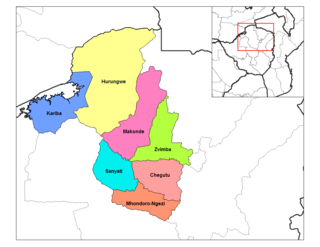
Chegutu District is a district of Mashonaland West Province, Zimbabwe.

Zvimba District Place in Mashonaland West, Zimbabwe

Zvimba District is a district of Mashonaland West Province, Zimbabwe.

Makonde District is a district in Zimbabwe.

The A5 Highway is a national road in Zimbabwe. It joins the cities of Harare and Bulawayo, and is hence known as the Harare-Bulawayo Highway or Harare-Bulawayo Road.

R3 Highway is a primary road in Zimbabwe from the capital city Harare to the Chirundu Border Post with Zambia. It is also known as the A1 Highway.

Chirundu-Beitbridge Regional Road Corridor

Chirundu-Beitbridge Road Corridor is a Trans-African Highway Network Zimbabwean link between South Africa and Zambia. It is also part of the North–South Corridor Project and the Cape to Cairo Road.

References

Coordinates: 17°42′00″S30°12′00″E / 17.70000°S 30.20000°E / -17.70000; 30.20000