Murray Morgan Bridge

Last updated
Murray Morgan Bridge
Murray Morgan Bridge from SW in 2023 - Tacoma, WA.jpg
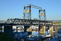
Murray Morgan Bridge from the southwest, 2023
Coordinates 47°15′14″N122°26′01″W / 47.25389°N 122.43361°W / 47.25389; -122.43361
CarriesPedestrians, cyclists, and vehicles via 11th Street
Crosses Thea Foss Waterway
(Navigable; 200 feet (61 m))
Locale Tacoma, Washington
Other name(s)City Waterway Bridge
OwnerCity of Tacoma
Characteristics
Design Vertical-lift
Material Steel
Total length3,200 feet (980 m)
Width70 feet (21 m)
Longest span214 feet (65 m)
No. of spans3
Clearance below 60 feet (18 m) closed
135 feet (41 m) open
No. of lanes 2
History
Designer Waddell & Harrington
Constructed byInternational Contract Company
Construction start1911
OpenedFebruary 15, 1913
City Waterway Bridge
NRHP reference No. 82004278
Added to NRHPJuly 16, 1982
Location
Murray Morgan Bridge

The Murray Morgan Bridge, also known as the 11th Street Bridge or City Waterway Bridge, is a vertical-lift bridge in Tacoma, Washington. It originally opened February 15, 1913, to replace an 1894 swing-span bridge. [1] The bridge connects downtown with the tidal flats, it spans the Thea Foss Waterway, originally known as the City Waterway. Designed by noted bridge engineering firm Waddell & Harrington, the bridge has some unusual features: higher above the water than most lift bridges, construction on a variable grade and an overhead span designed to carry a water pipe. [2] [3] The bridge structure also contained a series of switchback ramps that connected what is now Cliff Street with Dock Street. According to the Department of Transportation, the towers are 207 feet 1.75 inches (63.1381 m) above the water, with the road deck 60 feet (18 m) above the water level at zero tide. It was modified and updated in 1957 and was used to route State Route 509 through the tidal flats. The bridge was bypassed in the late 1990s when State Route 509 was routed around the edge of the tidal flats (see East 21st Street Bridge). While WSDOT wanted to tear down the bridge, the City of Tacoma convinced the state to transfer ownership to the City. [4] In the past, the bridge has been heavily used by commuters and emergency services in connecting the Port of Tacoma with downtown Tacoma. [5] [6]

Contents

In 2007, the bridge was closed because of safety concerns and the general wear and tear that the bridge had suffered in its near 100-year lifespan. Soon afterwards, the city began a large rehabilitation project to completely overhaul all aspects of the bridge. In 2010, the bridge began periodically opening to bikes and pedestrians. [7] In February 2013, the bridge re-opened to all traffic. [8]

Name

Originally known as the 11th Street Bridge, it was renamed May 21, 1997, to honor Tacoma-born Murray Morgan (1916–2000), the best-known Pacific Northwest historian of his generation, and author of "Skid Road", a history of Seattle, Washington. Morgan was a bridge tender on the bridge during the 1950s. In fact, he wrote most of "Skid Road" during quiet periods on the job. [9] [10]

Closure

The bridge was officially closed to vehicles on October 23, 2007, due to "life safety concerns". [11] [12] The bridge re-opened February 2013 after a large rehabilitation project. [8]

Opening

On February 1, 2013, the bridge re-opened after a large rehabilitation project was completely finished. Down from four lanes to two, the bridge is now solid black (its original color) and features antique-esque lighting (actually LED bulbs) to celebrate the bridge's centennial anniversary. The outer two lanes were converted to larger pedestrian paths and bike lanes. An elevator connects pedestrians and bikes to Dock Street below the bridge. The bridge's environmental impact has been lessened; a new water runoff system routes rainwater to tanks that contribute to a rain garden on the east side of the bridge. The computers, cables, and motors that operate the lift in the center of the structure were also updated. [8]

Damage

On December 15, 2010, it was discovered that thieves had broken into the mechanical room and stolen wiring from the control panel used to raise the bridge for ship traffic on the Foss Waterway. As part of the rehabilitation project, the computers and electrics in the bridge were replaced. [8]

See also

Related Research Articles

<span class="mw-page-title-main">Tacoma Narrows Bridge</span> Twin suspension bridges spanning the Tacoma Narrows strait of Puget Sound in Washington state

The Tacoma Narrows Bridge is a pair of twin suspension bridges that span the Tacoma Narrows strait of Puget Sound in Pierce County, Washington. The bridges connect the city of Tacoma with the Kitsap Peninsula and carry State Route 16 over the strait. Historically, the name "Tacoma Narrows Bridge" has applied to the original bridge nicknamed "Galloping Gertie", which opened in July 1940, but collapsed possibly because of aeroelastic flutter four months later, as well as the replacement of the original bridge which opened in 1950 and still stands today as the westbound lanes of the present-day two-bridge complex.

<span class="mw-page-title-main">Duwamish River</span> River in Washington, United States

The Duwamish River is the name of the lower 12 miles (19 km) of Washington state's Green River. Its industrialized estuary is known as the Duwamish Waterway. In 2009, the Duwamish Longhouse and Cultural Center was opened on the west bank of the river as part of the tribe's reassertion of its historic rights in the area and its continuing struggle for federal recognition of tribal status.

<span class="mw-page-title-main">Washington State Ferries</span> Public ferry service in Washington, US

Washington State Ferries (WSF) is a government agency that operates automobile and passenger ferry service in the U.S. state of Washington as part of the Washington State Department of Transportation. It runs ten routes serving 20 terminals located around Puget Sound and in the San Juan Islands, designated as part of the state highway system. The agency maintains a fleet of 21 vessels. In 2022, the system had a ridership of 17,375,400, or about 58,900 per weekday as of the third quarter of 2023. As of 2016, it was the largest ferry operator in the United States and the second-largest vehicular ferry system in the world, after BC Ferries.

<span class="mw-page-title-main">Interstate 705</span> Interstate highway in Tacoma, Washington

Interstate 705 (I-705), also known as the Tacoma Spur, is a short Interstate Highway in Tacoma, Washington, United States. It is a spur route of I-5 that connects the freeway to Downtown Tacoma, Tacoma's waterfront, North Tacoma, and the Tacoma Dome. I-705 was completed in 1988 and is one of the newest portions of the Interstate Highway System in Washington.

<span class="mw-page-title-main">Washington State Route 520</span> Freeway in Washington state

State Route 520 (SR 520) is a state highway and freeway in the Seattle metropolitan area, part of the U.S. state of Washington. It runs 13 miles (21 km) from Seattle in the west to Redmond in the east. The freeway connects Seattle to the Eastside region of King County via the Evergreen Point Floating Bridge on Lake Washington. SR 520 intersects several state highways, including Interstate 5 (I-5) in Seattle, I-405 in Bellevue, and SR 202 in Redmond.

<span class="mw-page-title-main">Washington State Route 99</span> Highway in the Seattle metropolitan area, Washington, U.S.

State Route 99 (SR 99), also known as the Pacific Highway, is a state highway in the Seattle metropolitan area, part of the U.S. state of Washington. It runs 49 miles (79 km) from Fife to Everett, passing through the cities of Federal Way, SeaTac, Seattle, Shoreline, and Lynnwood. The route primarily follows arterial streets, including Aurora Avenue, and has several freeway segments, including the tolled SR 99 Tunnel in Downtown Seattle. SR 99 was officially named the William P. Stewart Memorial Highway by the state legislature in 2016, after a campaign to replace an unofficial moniker honoring Confederate president Jefferson Davis.

<span class="mw-page-title-main">Hood Canal Bridge</span> Pontoon bridge in western Washington State, United States

The Hood Canal Bridge is a floating bridge in the northwest United States, located in western Washington. It carries State Route 104 across Hood Canal in Puget Sound and connects the Olympic and Kitsap Peninsulas. At 7,869 feet in length, it is the longest floating bridge in the world located in a saltwater tidal basin, and the third longest floating bridge overall. It opened in 1961 and was the second concrete floating bridge constructed in Washington. Since that time, it has become a vital link for local residents, freight haulers, commuters, and recreational travelers. The convenience it provides has had a major impact on economic development, especially in eastern Jefferson County.

<span class="mw-page-title-main">Sellwood Bridge</span> Bridge in Portland, OR

The Sellwood Bridge is a deck arch bridge that spans the Willamette River in Portland, Oregon, in the United States. The current bridge opened in 2016 and replaced a 1925 span that had carried the same name. The original bridge was Portland's first fixed-span bridge and, being the only river crossing for miles in each direction, the busiest two-lane bridge in Oregon. The Sellwood Bridge links the Sellwood and Westmoreland neighborhoods of Portland on the east side with Oregon Route 43/Macadam Avenue on the west side. At its east end it leads to Tacoma Street. The bridge is owned and operated by Multnomah County. The original span of 1925 was a steel truss bridge, while its 2016 replacement is a deck-arch-type bridge.

<span class="mw-page-title-main">Lewis and Clark Bridge (Columbia River)</span> Historic bridge in Washington state and Oregon, USA

The Lewis and Clark Bridge is a cantilever bridge that spans the Columbia River between Longview, Washington, and Rainier, Oregon. At the time of its completion, it had the longest cantilever span in the United States.

<span class="mw-page-title-main">Washington State Route 16</span> State highway in the U.S. state of Washington

State Route 16 (SR 16) is a 27.16-mile-long (43.71 km) state highway in the U.S. state of Washington, connecting Pierce and Kitsap counties. The highway, signed as east–west, begins at an interchange with Interstate 5 (I-5) in Tacoma and travels through the city as a freeway towards the Tacoma Narrows. SR 16 crosses the narrows onto the Kitsap Peninsula on the partially tolled Tacoma Narrows Bridge and continues through Gig Harbor and Port Orchard before the freeway ends in Gorst. The designation ends at an intersection with SR 3 southwest of the beginning of its freeway through Bremerton and Poulsbo. SR 16 is designated as a Strategic Highway Network (STRAHNET) corridor within the National Highway System as the main thoroughfare connecting Tacoma to Naval Base Kitsap and a part of the Highways of Statewide Significance program.

<span class="mw-page-title-main">Washington State Route 509</span> Highway in Washington

State Route 509 (SR 509) is a 35.17-mile-long (56.60 km) state highway in the U.S. state of Washington, connecting Tacoma in Pierce County to Seattle in King County. The highway travels north from Interstate 705 (I-705) in Tacoma to SR 99 south of downtown Seattle. It serves cities along the Puget Sound and west of Seattle–Tacoma International Airport in south King County, including Federal Way, Des Moines, and Burien. SR 509 is part of the National Highway System and is a limited-access highway near the Port of Tacoma and from Burien to its northern terminus in Seattle.

<span class="mw-page-title-main">Washington State Route 167</span> Highway in Washington

State Route 167 (SR 167) is a state highway in the Seattle metropolitan area of Washington state. It is commonly known as the Valley Freeway and serves the Green River Valley from Tacoma to Renton, primarily as a four-lane freeway. The 28-mile (45 km) highway begins in Tacoma at an interchange with Interstate 5 (I-5) and travels southeast to Puyallup as an undivided road. It then turns northeast onto a freeway and passes through interchanges with SR 512 in Puyallup and SR 410 in Sumner, continuing north through Auburn and Kent. After an interchange with I-405 in Renton, it terminates at an intersection with SR 900.

<span class="mw-page-title-main">Washington State Route 516</span> Highway in Washington

State Route 516 (SR 516) is a 16.49-mile-long (26.54 km) state highway in the U.S. state of Washington, serving communities in southern King County. The highway travels east as the Kent-Des Moines Road and the Kent-Kangley Road from a concurrency with SR 509 in Des Moines through Kent and Covington to an intersection with SR 169 in Maple Valley. SR 516, designated as part of the National Highway System within Kent, intersects three major freeways in the area: Interstate 5 (I-5) in western Kent, SR 167 in downtown Kent, and SR 18 in Covington. The roadway, built in the 1890s, was codified in 1937 as Secondary State Highway 1K (SSH 1K) from Des Moines to Kent and SSH 5A from Kent to Maple Valley. The two highways were combined during the 1964 highway renumbering to form SR 516 on its current route.

<span class="mw-page-title-main">Interstate 5 in Washington</span> Interstate highway in Washington

Interstate 5 (I-5) is an Interstate Highway on the West Coast of the United States that serves as the region's primary north–south route. It spans 277 miles (446 km) across the state of Washington, from the Oregon state border at Vancouver, through the Puget Sound region, to the Canadian border at Blaine. Within the Seattle metropolitan area, the freeway connects the cities of Tacoma, Seattle, and Everett.

<span class="mw-page-title-main">Washington State Route 162</span> A rural state highway in the U.S. state of Washington

State Route 162 (SR 162) is a 17.37-mile-long (27.95 km) state highway in the U.S. state of Washington, serving rural Pierce County. The highway travels from an interchange with SR 410 in Sumner and travels south along the Puyallup River to Orting and northeast to South Prairie, ending at an intersection with SR 165 near Buckley. SR 162 was established in 1964 as the successor to Secondary State Highway 5E (SSH 5E), which was codified in 1937. The highway crossed the Puyallup River northwest of Orting on the McMillin Bridge, which opened in 1934 and was replaced with a newer bridge that opened in 2015.

<span class="mw-page-title-main">Tacoma Dome Station</span> Intermodal transportation hub in Tacoma, Washington

Tacoma Dome Station is a train station and transit hub in Tacoma, Washington, United States. It is served by Amtrak trains, the S Line of Sounder commuter rail, the T Line of Link light rail, and buses on local and intercity routes. Located near the Tacoma Dome south of Downtown Tacoma, the station consists of two train platforms used by Sounder and Amtrak trains, a platform for the T Line, a bus terminal, and two parking garages. The Sounder station is integrated into Freighthouse Square, a former Milwaukee Road depot that was converted into a shopping mall, and is on the east side of the Amtrak station.

<span class="mw-page-title-main">East 21st Street Bridge</span> Bridge in Washington, United States

The East 21st Street Bridge is a 682-foot (208 m) or 707-foot (215 m) or 992-foot (302 m) long cable-stayed bridge in Tacoma, Washington completed in January 1997. The bridge, whose most significant feature is two 180-foot (55 m) tall towers, carries four lanes State Route 509 across the Thea Foss Waterway from downtown Tacoma to the Port of Tacoma. SR 509 ends at a single point urban interchange with Interstate 705 west of the bridge, built as part of the same $165.3 million WSDOT project that also funded the bridge's construction.

<span class="mw-page-title-main">Evergreen Point Floating Bridge</span> Floating bridge carrying a freeway in Seattle, Washington

The Evergreen Point Floating Bridge, also known as the 520 Bridge and officially the Governor Albert D. Rosellini Bridge, carries Washington State Route 520 across Lake Washington from Seattle to its eastern suburbs. The 7,710-foot-long (2,350 m) floating span is the longest floating bridge in the world, as well as the world's widest measuring 116 feet (35 m) at its midpoint.

References

  1. Long, Priscilla (2003-09-06). "the Free Online Encyclopedia of Washington State History". HistoryLink.org. Retrieved 2011-08-20.
  2. Soderberg, Lisa (1979). HAER Inventory - City Waterway Bridge. Historic American Engineering Record . Retrieved June 4, 2021.
  3. "WSDOT: City Waterway Bridge". Wsdot.wa.gov. 2006-05-18. Retrieved 2011-08-20.
  4. Santos, Melissa (November 12, 2007). "Broken promises on bridge". The News Tribune . Tacoma, Washington. Archived from the original on September 13, 2012. Retrieved August 15, 2012.
  5. "Murray Morgan Bridge Frequently Asked Questions". City of Tacoma. Archived from the original on September 7, 2012. Retrieved August 15, 2012.
  6. https://www.thenewstribune.com/2010/04/01/1131184/murray-morgan-bridge-reopening.html.{{cite web}}: Missing or empty |title= (help)[ dead link ]
  7. Larson, John (30 March 2010). "Murray Morgan Bridge opens for pedestrians". Tacoma, Washington. Archived from the original on 2015-09-24. Retrieved 2 February 2013.
  8. 1 2 3 4 Gillie, John (1 February 2013). "Tacoma's Murray Morgan Bridge reopening". The News Tribune . Tacoma, Washington. Archived from the original on 4 February 2013. Retrieved 2 February 2013.
  9. Long, Priscilla (2003-05-16). "the Free Online Encyclopedia of Washington State History". HistoryLink.org. Retrieved 2011-08-20.
  10. Lange, Greg (2002-11-29). "the Free Online Encyclopedia of Washington State History". HistoryLink.org. Retrieved 2011-08-20.
  11. Hagey, Jason (October 24, 2007). "Murray Morgan closed". The News Tribune . Archived from the original on February 4, 2013. Retrieved August 15, 2012.
  12. "Safety Concerns Close Murray Morgan Bridge" (Press release). WSDOT.