Related Research Articles

King George County is a county located in the Commonwealth of Virginia. As of the 2020 census, the population sits at 26,723. Its county seat is the town of King George.

Caroline County is a United States county located in the eastern part of the Commonwealth of Virginia. The northern boundary of the county borders on the Rappahannock River, notably at the historic town of Port Royal. The Caroline county seat is Bowling Green.

The Colony of Virginia, chartered in 1606 and settled in 1607, was the first enduring English colony in North America, following failed proprietary attempts at settlement on Newfoundland by Sir Humphrey Gilbert in 1583, and the subsequent farther south Roanoke Island by Sir Walter Raleigh in the late 1580s.

The Powhatan people may refer to any of the indigenous Algonquian people that are traditionally from eastern Virginia. All of the Powhatan groups descend from the Powhatan Confederacy. In some instances, The Powhatan may refer to one of the leaders of the people. This is most commonly the case in historical records from English colonial accounts. The Powhatans have also been known as Virginia Algonquians, as the Powhatan language is an eastern-Algonquian language, also known as Virginia Algonquian. It is estimated that there were about 14,000–21,000 Powhatan people in eastern Virginia, when English colonists established Jamestown in 1607.
Warrosquoake Shire was officially formed in 1634 in the Virginia colony, but had already been known as "Warascoyack County" before this. It was named for an Algonquian-speaking tribe that was part of the Powhatan Confederacy. The county was renamed in 1637 as Isle of Wight County, after an island in the English Channel.
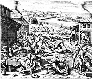
The Indian massacre of 1622, popularly known as the Jamestown massacre, took place in the English Colony of Virginia, in what is now the United States, on 22 March 1622. John Smith, though he had not been in Virginia since 1609 and was not an eyewitness, related in his History of Virginia that warriors of the Powhatan "came unarmed into our houses with deer, turkeys, fish, fruits, and other provisions to sell us". The Powhatan then grabbed any tools or weapons available and killed all the English settlers they found, including men, women, children of all ages. Chief Opechancanough led the Powhatan Confederacy in a coordinated series of surprise attacks, and they killed a total of 347 people, a quarter of the population of the Virginia colony.
The Monacan Indian Nation is one of eleven Native American tribes recognized since the late 20th century by the U.S. state of Virginia. In January 2018, the United States Congress passed an act to provide federal recognition as tribes to the Monacan and five other tribes in Virginia. They had earlier been so disrupted by land loss, warfare, intermarriage, and discrimination that the main society believed they no longer were "Indians". However, the Monacan reorganized and asserted their culture.
The Chickahominy are a federally recognized tribe of Virginian Native Americans who primarily live in Charles City County, located along the James River midway between Richmond and Williamsburg in the Commonwealth of Virginia. This area of the Tidewater is not far from where they were living in 1600, before the arrival of colonists from England. They were officially recognized by the state in 1983 and by the federal government in January 2018.

The Manahoac, also recorded as Mahock, were a small group of Siouan-language Native Americans in northern Virginia at the time of European contact. They numbered approximately 1,000 and lived primarily along the Rappahannock River west of modern Fredericksburg and the Fall Line, and east of the Blue Ridge Mountains. They united with the Monacan, the Occaneechi, the Saponi and the Tutelo. They disappeared from the historical record after 1728.

The Native American tribes in Virginia are the indigenous tribes who currently live or have historically lived in what is now the Commonwealth of Virginia in the United States of America.

The Rappahannock are a federally recognized tribe in Virginia and one of the eleven state-recognized tribes. They are made up of descendants of several small Algonquian-speaking tribes who merged in the late 17th century. In January 2018, they were one of six Virginia tribes to gain federal recognition by passage of the Thomasina E. Jordan Indian Tribes of Virginia Federal Recognition Act of 2017.

The Mattaponi tribe is one of only two Virginia Indian tribes in the Commonwealth of Virginia that owns reservation land, which it has held since the colonial era. The larger Mattaponi Indian Tribe lives in King William County on the reservation, which stretches along the borders of the Mattaponi River, near West Point, Virginia.
Tsenacommacah is the name given by the Powhatan people to their native homeland, the area encompassing all of Tidewater Virginia and parts of the Eastern Shore. More precisely, its boundaries spanned 100 miles (160 km) by 100 miles (160 km) from near the south side of the mouth of the James River all the way north to the south end of the Potomac River and from the Eastern Shore west to about the Fall Line of the rivers.
The Anglo–Powhatan Wars were three wars fought between settlers of the Virginia Colony and Algonquin Indians of the Powhatan Confederacy in the early seventeenth century. The first war started in 1609 and ended in a peace settlement in 1614. The second war lasted from 1622 to 1626. The third war lasted from 1644 until 1646 and ended when Opechancanough was captured and killed. That war resulted in a defined boundary between the Indians and colonial lands that could only be crossed for official business with a special pass. This situation lasted until 1677 and the Treaty of Middle Plantation which established Indian reservations following Bacon's Rebellion.
Kiskiack was a Native American tribal group of the Powhatan Confederacy in what is present-day York County, Virginia. The name means "Wide Land" or "Bread Place" in the native language, one of the Virginia Algonquian languages. It was also the name of their village on the Virginia Peninsula.
Patawomeck is a Native American tribe based in Stafford County, Virginia, along the Potomac River. Patawomeck is another spelling of Potomac.

The Doeg were a Native American people who lived in Virginia. They spoke an Algonquian language and may have been a branch of the Nanticoke tribe, historically based on the Eastern Shore of Maryland. The Nanticoke considered the Algonquian Lenape as "grandfathers". The Doeg are known for a raid in July 1675 that contributed to colonists' uprising in Bacon's Rebellion.
Land's End Wildlife Management Area is a 462-acre (187 ha) Wildlife Management Area (WMA) in southeastern King George County, Virginia. The site is a mixture of open farmland, woodland, and wetland, and comprises two separate tracts: The 50-acre (20 ha) Salem Church Tract, and the 412-acre (167 ha) Land's End Tract. The area is bordered on two sides by the Rappahannock River and on one by Jett's Creek, and is primarily managed as a refuge for migrating waterfowl; Canada geese can often be seen in the winter feeding on fields of corn, milo, and winter wheat in the area, and resting in the nearby Nanzatico Bay. Among the other species often seen on the property are bald eagles, deer, wild turkey, and songbirds.
The Appomattoc were a historic tribe of Virginia Indians speaking an Algonquian language, and residing along the lower Appomattox River, in the area of what is now Petersburg, Colonial Heights, Chesterfield and Dinwiddie Counties in present-day southeast Virginia.
Totuskey Creek is a tributary of the Rappahannock River located in Richmond County, Virginia. The creek meets the river near Wellford, Virginia.
References
- Gwenda Morgan, "Sold into Slavery in Retribution against the Nanziattico Indians," Virginia Cavalcade, 33 (Spring 1984):168-73.
