New Haven is a city in New Haven County, Connecticut, United States. It is located on New Haven Harbor on the northern shore of Long Island Sound and is part of the New York City metropolitan area. With a population of 135,081 as determined by the 2020 U.S. census, New Haven is the third largest city in Connecticut after Bridgeport and Stamford, the largest city in the South Central Connecticut Planning Region, and the principal municipality of Greater New Haven, which had a total population of 864,835 in 2020. Prior to 1960, it was the county seat of New Haven County until the county governments were abolished that year.

The New Haven Green is a 16-acre (65,000 m2) privately owned park and recreation area located in the downtown district of the city of New Haven, Connecticut, United States. It comprises the central square of the nine-square settlement plan of the original Puritan colonists in New Haven, and was designed and surveyed by colonist John Brockett. Today the Green is bordered by the modern paved roads of College, Chapel, Church, and Elm streets. Temple Street bisects the Green into upper (northwest) and lower (southeast) halves.

Downtown New Haven is the neighborhood located in the heart of the city of New Haven, Connecticut. It is made up of the original nine squares laid out in 1638 to form New Haven, including the New Haven Green, and the immediate surrounding central business district, as well as a significant portion of the Yale University campus. The area includes many restaurants, cafes, theaters and stores. Downtown is bordered by Wooster Square to the east, Long Wharf to the southeast, the Hill neighborhood to the south, the Dwight neighborhood to the west, the Dixwell neighborhood to the northwest, the Prospect Hill area to the north, and East Rock to the northeast.

East Rock is a neighborhood in the city of New Haven, Connecticut, named for nearby East Rock, a prominent trap rock ridge. The area is home to a large group of Yale students, staff, and faculty, as well as many young professionals and families. Writing in the Times Literary Supplement, Hirsh Sawhney describes East Rock as a "yuppie enclave", which is "increasingly composed of wealthy professionals and graduate students, most of whom are affiliated with Yale University, whose lavish campus lies just over a mile away" East Rock is also a popular destination for cyclists, as a city bike lane runs along Orange Street, the neighborhood's spine. East Rock is the safest neighborhood in New Haven County. East Rock is home to East Rock Park, which is frequently visited by families and tourists.

City Point is an area in what is now The Hill neighborhood of the city of New Haven, Connecticut, located in the southwestern portion of the city. The City Point area was, when settled and through the 18th century, a relatively narrow peninsula extending south into New Haven Harbor, located where the West River empties into the harbor. Areas adjacent to the original peninsula have since been filled in, broadening its shoulders, and Interstate 95 has cut across it. The Oyster Point Historic District is a 26-acre (11 ha) historic district encompassing an area of relatively old buildings in City Point south of I-95.
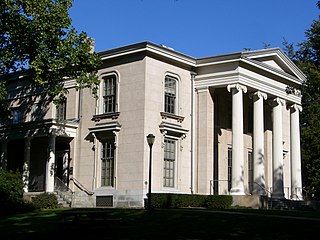
Hillhouse Avenue is a street in New Haven, Connecticut, famous for its many nineteenth century mansions, including the president's house at Yale University. Both Charles Dickens and Mark Twain have described it as "the most beautiful street in America." Much of the avenue is included in the Hillhouse Avenue Historic District, which extends to include houses on adjacent streets.

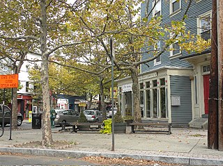
Westville Village Historic District is a historic district representing most of the commercial center of the Westville neighborhood of New Haven, Connecticut. This center developed in the 19th century as an industrial mill village distinct from the city center, and retains many architectural features of that period. The district was listed on the National Register of Historic Places in 2003, and its boundaries were increased slightly in 2006.

The Wooster Square Historic District encompasses much of the Wooster Square neighborhood of New Haven, Connecticut. Centered on a rectangular park named in honor of General David Wooster, the area was developed as a residential neighborhood beginning in the 1820s, and was by the 1840s a desirable area to live, with many high-quality Greek Revival homes. In the 1950s the area was the subject of a major community-led preservation effort that drew national attention. The district was listed on the National Register of Historic Places in 1971.

The Main Street Historic District in Danbury, Connecticut, United States, is the oldest section of that city, at its geographical center. It has long been the city's commercial core and downtown. Its 132 buildings, 97 of which are considered contributing properties, include government buildings, churches, commercial establishments and residences, all in a variety of architectural styles from the late 18th century to the early 20th. It is the only major industrial downtown of its size in Connecticut not to have developed around either port facilities or a water power site.

The South Britain Historic District encompasses the core of the unincorporated village of South Britain in Southbury, Connecticut, United States. The village arose in the 18th century as an industrial center serving the surrounding agricultural community, powered by the Pomperaug River, and rivalled the town center of Southbury in importance. The district was listed on the National Register of Historic Places in 1987.

The Dwight Street Historic District is an irregularly shaped 135-acre (55 ha) historic district in New Haven, Connecticut. The district is located immediately west of the center of Downtown New Haven and is generally bounded by Elm Street on the north, Park Street on the east, North Frontage Road on the south, and Sherman Avenue on the west. It contains one of the city's highest concentrations of well-preserved 19th and early 20th-century residential architecture, much of which was developed for the working classes in the city's factories. It was listed on the National Register of Historic Places in 1983. The historic district includes most of the Dwight neighborhood and several blocks of the northeast corner of the West River neighborhood.
The city of New Haven, Connecticut has many distinct neighborhoods. In addition to Downtown, centered on the central business district and the Green, are the following neighborhoods: the west central neighborhoods of Dixwell and Dwight; the southern neighborhoods of The Hill, historic water-front City Point, and the harborside district of Long Wharf; the western neighborhoods of Edgewood, West River, Westville, Amity, and West Rock; East Rock, Cedar Hill, Prospect Hill, and Newhallville in the northern side of town; the east central neighborhoods of Mill River and Wooster Square, an Italian-American neighborhood; Fair Haven, an immigrant community located between the Mill and Quinnipiac rivers; Quinnipiac Meadows and Fair Haven Heights across the Quinnipiac River; and facing the eastern side of the harbor, The Annex and East Shore.

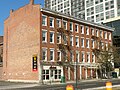
The Chapel Street Historic District is a 23-acre (9.3 ha) historic district in the Downtown New Haven area of the city of New Haven, Connecticut. It was listed on the National Register of Historic Places in 1984. The district covers the southwestern corner of Downtown New Haven, including properties from Park Street to Temple Street between Chapel and Crown streets, and properties from High Street to Temple Street between George and Crown streets. It is bordered on the north by the New Haven Green and the Yale University campus. The western edge borders the Dwight Street Historic District. The eastern and southern edges of the district abut areas of more modern development.

The Orange Street Historic District encompasses a large residential in the East Rock section of New Haven, Connecticut. Roughly bounded by Orange, Cottage, Eagle, State, and Audubon Streets, this area saw growth between about 1830 and 1900, and includes a broad diversity of well-preserved 19th-century residential structures. It was listed on the U.S. National Register of Historic Places in 1985. At that time, it included 546 buildings deemed to contribute to the historic character of the area.

Trowbridge Square Historic District, originally known as Village of Spireworth and Mount Pleasant, is a well-preserved 19th-century neighborhood in the Hill section of New Haven, Connecticut. Roughly bounded by Columbus, Howard, and Union Avenues, and Church Street on the east, the area was laid out in 1830 and developed as a working-class neighborhood. It retains its historic streetscape, and many original buildings, representing modest versions of a diversity of mid-to-late 19th century styles. The district was listed on the National Register of Historic Places in 1985.
The Upper State Street Historic District encompasses a well-preserved neighborhood commercial district of the late 19th century in the East Rock neighborhood of New Haven, Connecticut. The district is an irregular strip running NNE to SSW mainly along State Street in New Haven, one block west of Interstate 91, the highway which determines the district's eastern and southern borders. The district was listed on the U.S. National Register of Historic Places in 1984.

Leoni W. Robinson (1851-1923) was a leading architect in New Haven, Connecticut.

Palmyra Village Historic District is a national historic district at Palmyra in Wayne County, New York.

Sidney Mason Stone was a prominent Connecticut architect and builder known for designs of churches, institutional buildings and residences. His creations incorporated Greek Revival, Romanesque, Gothic, Italianate and other styles popular in the 19th century. He served in several civic capacities in the city of New Haven and statewide and as mentor to Yale students prior to the establishment of that university's School of Architecture. He was the father of Harriet Mulford Stone, better known to readers of children's literature as Margaret Sidney, creator of the Five Little Peppers series.

The Colony Street-West Main Street Historic District encompasses a major section of the historic downtown area of Meriden, Connecticut. Extending north and west from the junction of Colony and West Main Streets, this area was developed commercially after the arrival of the railroad line which runs just to its east. Despite some redevelopment, the historic commercial and mixed residential-commercial buildings convey the appearance of a typical late 19th or early 20th-century downtown. The district was listed on the National Register of Historic Places in 1987. Since its listing, a number of the historic buildings have been demolished.