
The Yaquina Bay Bridge is an arch bridge that spans Yaquina Bay south of Newport, Oregon. It is one of the most recognizable of the U.S. Route 101 bridges designed by Conde McCullough and one of eleven major bridges on the Oregon Coast Highway designed by him. It superseded the last ferry crossing on the highway.
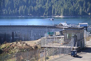
Cushman Dam No. 1 is a hydroelectric dam on the North Fork of the Skokomish River in Mason County, Washington, which in derogation of the natural and treaty rights of the Native inhabitants impounded and enlarged the formerly natural Lake Cushman, leading to damage claims in excess of $5 billion and an eventual settlement agreement with the Skokomish tribe that terminates the right to operate the dam(s) after 2048. It was built by Tacoma City Light in 1924–1926. Tacoma's demand for electricity grew rapidly after World War I. Tacoma City Light's Nisqually River Hydroelectric Project, built in 1912, could not meet the demand and the utility decided to build a new hydroelectric project on the North Fork Skokomish River. The dam and powerhouse first began to deliver electricity on February 12, 1926.
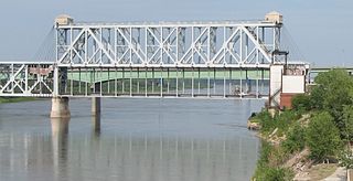
The Armour-Swift-Burlington (ASB) Bridge, also known as the North Kansas City Bridge and the LRC Bridge, is a rail crossing over the Missouri River in Kansas City, Missouri, that formerly handled automobile traffic.

The McMillin Bridge is a concrete half-through truss bridge crossing the Puyallup River, in Pierce County, Washington, built in 1934.

The Fairfax Bridge is a steel-lattice three-hinged arch bridge spanning the Carbon River on State Route 165 in Pierce County, Washington. Previous to the construction of the bridge in 1921, the only route south to the area around Fairfax was by train. At a total cost of $80,000, the bridge's deck sits 250 feet (76 m) above the river. Being a single-lane bridge, vehicles must yield to oncoming traffic already on the bridge.

The Purdy Bridge is a continuous hollow-box girder bridge that spans 550 feet (170 m) between Henderson Bay, Washington and Burley Lagoon, connecting Purdy, Washington with the Purdy Sand Spit Park and Wauna, Washington. It was built on September 29, 1937, and at the time was the longest continuous box girder bridge in the United States, at a cost of $62,000 from a design by Homer M. Hadley. At the time it was built, Purdy Bridge was the first bridge in the United States to utilize a reinforced-concrete box girder design.

The Christine Falls Bridge is a reinforced concrete arch bridge in Mount Rainier National Park, spanning Van Trump Creek at Christine Falls. The bridge was built in 1927–1928 by contractor J. D. Tobin of Portland, Oregon, who built the Narada Falls Bridge at the same time. The arch has a three-centered profile and spans 56 feet (17 m). The bridge is 30 feet (9.1 m) wide. It was faced with rubble stonework and is an example of National Park Service Rustic design.

The White River Bridge was built in 1929 in Mount Rainier National Park as part of the Yakima Park Road project. The new road was planned to open up access to the northeastern portion of the park. The bridge, spanning the White River, was built by contractor John D. Tobin of Portland, Oregon, who had previously built the Narada Falls Bridge and the Christine Falls Bridges, both listed on the National Register of Historic Places. Plans for the bridge were drawn by the National Park Service Branch of Plans and Designs in the National Park Service Rustic style, with construction supervision by NPS landscape architect Ernest A. Davidson. The three-centered arch spans 60 feet (18 m), with a stone-faced concrete structure.

The St. Andrews Creek Bridge was built in 1930-31 as part of the West Side Road in Mount Rainier National Park. The bridge spans 26 feet (7.9 m) and is almost 34 feet (10 m) wide, carrying a two-lane road on a stone-faced concrete bridge. The West Side Road was planned to link the Nisqually and Carbon River entrances to the park, but only 13 miles (21 km) were completed in six years.

The South Puyallup River Bridge was built in 1930–31 in Mount Rainier National Park as part of the West Side Road project, planned to link the park's Nisqually and Carbon River entrances. The stone-faced reinforced concrete bridge was designed by the National Park Service and the Bureau of Public Roads. It spans 42 feet (13 m) and is almost 35 feet (11 m) wide, carrying two lanes of traffic.

The Columbia River Bridge, also known as the Bridgeport Bridge, at Bridgeport, Washington was built to span the Columbia River in 1950. Composed of three spans, the bridge is a steel continuous riveted deck truss carrying Washington State Route 17 on a 26-foot (7.9 m) wide roadway and two 3-foot (0.91 m) sidewalks. The center portion of the bridge spans 300 feet (91 m), flanked by 250-foot (76 m) end spans. The 70-foot (21 m) north approach span and the 100-foot (30 m) south approach span are supported by steel plate girders. The bridge played a significant role in the construction of the Chief Joseph Dam just upstream, as no bridge crossing had previously existed in the area. Construction on the dam started in 1945 and was completed, apart from the powerplant, in 1955. The bridge was designed and built by the U.S. Army Corps of Engineers as part of the Chief Joseph dam project, and is significant for its association with the project and as a major crossing of the Columbia.
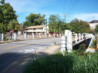
Patton Bridge is a bridge located in Auburn, Washington listed on the National Register of Historic Places. The bridge spans the Green River near metropolitan Auburn, Washington. It was designed by bridge engineer and designer Homer M. Hadley. The combination of concrete and steel box girders employed in the bridge's represents a variation of the box girder bridge style. The Patton Bridge was the only structure built between 1941 and 1950, which exhibits this innovative modification of the box girder design.
The Jefferson Street Viaduct is an historic structure located in Ottumwa, Iowa, United States. The riveted Warren deck truss bridge was completed in 1936. It was listed on the National Register of Historic Places in 1998 as a part of the Highway Bridges of Iowa MPS.

Waddell & Harrington was an American engineering company that designed bridges from 1907 to 1915. It was formed in 1907 as a partnership of John Alexander Low Waddell (1854–1938) and John Lyle Harrington (1868–1942) and was based in Kansas City, Missouri, but had offices in Portland, Oregon, and Vancouver, British Columbia. The company designed more than 30 vertical-lift bridges for highways and railroads.

The North 23rd Street Bridge in Tacoma, Washington, United States, is a concrete rigid frame bridge that was designed by engineers Waddell & Harrington in 1909. It was built for the City of Tacoma by contractors Creelman, Putman, and Healy.

The McKee Street Bridge carries McKee Street across Buffalo Bayou in Houston, Texas. Built in 1932, the three-span reinforced concrete girder bridge connects the Second and Fifth Ward areas, northeast of downtown Houston. The bridge was listed on the National Register of Historic Places on September 3, 2002.

The Maple Street Overpass is a historic bridge in Fayetteville, Arkansas. The bridge carries West Maple Street over the railroad tracks running just east of the University of Arkansas at Fayetteville campus. It is a reinforced concrete single-span arch, 60 feet (18 m) in length and 25 feet (7.6 m) in width. The bridge has a decorative Art Deco balustrade with inset lights on both sides. The bridge was designed by regional bridge designer Frederick Lutt Johann, and built in 1936.
The Lafayette Street Overpass is a historic bridge in Fayetteville, Arkansas. It is a three-span reinforced concrete girder structure, carrying Lafayette Street over the tracks of the St. Louis–San Francisco Railway. The bridge is about 120 feet (37 m) long and 30 feet (9.1 m) wide, and consists of reinforced concrete spans resting on concrete abutments. It features an Art Deco railing, with a metal balustrade covering concrete piers with inset light fixtures. The bridge was built in 1938 by Edward B. Mooney, Inc.

The First Street Bridge in Napa, California brings First Street over the Napa River. It was built in 1914 and was listed on the National Register of Historic Places in 2004.

The West Fifth Street Bridge is a historic cantilever concrete girder bridge in downtown Austin, Texas. Built in 1931, the bridge carries Fifth Street across Shoal Creek to link central Austin with neighborhoods that were then the city's western suburbs. It is one of only a handful of curved cantilever girder bridges in Texas, built as part of the city's 1928 master plan for urban development and beautification. The bridge was added to the National Register of Historic Places in 2019.

