North Clifton

Last updated

North Clifton
Village and civil parish
North Clifton village approach - geograph.org.uk - 1712257.jpg
North Clifton village approach
North Clifton
Parish map
Nottinghamshire UK location map.svg
Red pog.svg
North Clifton
Location within Nottinghamshire
Area1.73 sq mi (4.5 km2)
Population176 (2021)
  Density 102/sq mi (39/km2)
OS grid reference SK 823721
  London 120 mi (190 km)  SSE
District
Shire county
Region
Country England
Sovereign state United Kingdom
Post town Newark
Postcode district NG23
Dialling code 01522 / 01777
Police Nottinghamshire
Fire Nottinghamshire
Ambulance East Midlands
UK Parliament
List of places
UK
England
Nottinghamshire
53°14′25″N0°46′02″W / 53.240192°N 0.76724857°W / 53.240192; -0.76724857

North Clifton is a village and civil parish about 12 miles north of Newark-on-Trent, [1] in the Newark and Sherwood district, within the county of Nottinghamshire, England. In 2011, the parish had a population of 216, [2] and this dropped to 176 at the 2021 census. [3] The parish touches Thorney, Fledborough, Newton on Trent, South Clifton and Ragnall. [4]

Contents

Features

North Clifton has a church called St George which is Grade II* Listed. [5] North Clifton Primary School is on Church Lane. [6] Clifton-on-Trent railway station opened in 1897 and closed to passengers in 1955 and entirely in 1964. [7] There are four listed buildings in North Clifton. [8]

History

The name "Clifton" means 'Cliff farm/settlement'. [9] North and South Clifton were recorded in the Domesday Book as Cliftone/Cliftune/Cli(s)tone. [10] Alternative names for North Clifton are "Clifton" and "Clifton North". [11] North Clifton parish also included the townships of South Clifton, Harby and Spalford [12] which became separate parishes in 1866. [13] [14] [15]

Francis White's Directory of Nottinghamshire of 1853 records that:

"North Clifton parish comprises the four villages and townships of North Clifton, South Clifton, Harby and Spalford, which maintain their poor separately, and contain together 1,107 inhabitants and 5.040 acres (20,400 m2) of land, now valued at £6,230, which was all exonerated from tithes at the enclosure, and anciently formed four manors of the Bishop of Lincoln's fee, and one of Roger de Bisli's, which in after times passed to the Lovelots, Pigotts and Willoughbys. North Clifton is a small village on the east bank of the Trent, 12½ miles north by east of Newark, near a long cliff, in which numerous fragments of urns, bones and scalps have been found, near the spot which is supposed to have been anciently occupied by a castle. The church, dedicated to St George, stands on an eminence between North and South Clifton, and was re-pewed in 1831. The vicarage, valued in the King's books at £7 6s, and now at £176, is enjoyed by the Rev. Frederick Parry Hodges D. D. The Rev. G.C. Gordon M.A. is the curate, and resides at the Vicarage House, South Clifton. The prebendary of North Clifton, in Lincoln Cathedral, is the patron and appropriator." [16]

Related Research Articles

<span class="mw-page-title-main">Ollerton</span> Town in Nottinghamshire, England

Ollerton is a town and former civil parish, now in the parish of Ollerton and Boughton, in the Newark and Sherwood district, in the county of Nottinghamshire, England, on the edge of Sherwood Forest in the area known as the Dukeries. The population of Ollerton and Boughton at the 2011 census was 9,840.

<span class="mw-page-title-main">Harby, Nottinghamshire</span> Village and civil parish in Nottinghamshire, England

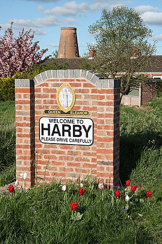
Harby is a village and civil parish in the Newark and Sherwood district of Nottinghamshire, England. It is close to Doddington, Lincolnshire, and is the easternmost settlement in Nottinghamshire, the boundary separating the two. According to the 2011 census, it had a population of 336, up from 289 at the 2001 census. It increased to 346 at the 2021 census.

<span class="mw-page-title-main">Alverton</span> Hamlet and civil parish in Nottinghamshire, England

Alverton is an English hamlet and civil parish in the Newark and Sherwood district of Nottinghamshire. It is joined by neighbouring Kilvington to form an area for a parish meeting. It contains 22 houses surrounded by farmland, and reported 61 residents in the 2021 census. The River Devon and its tributary, the Winter Beck, run along its eastern border.

<span class="mw-page-title-main">Newark Wapentake</span>

Newark was a wapentake of the historic county of Nottinghamshire, England.

<span class="mw-page-title-main">Carlton-on-Trent</span> Village and civil parish in England

Carlton-on-Trent is a small village and civil parish in England, located between the River Trent and the A1 road near Newark-on-Trent in Nottinghamshire. The population of the civil parish was 228 at the 2001 census, increasing only marginally to 229 at the 2011 census and similarly to 230 at the 2021 census.

<span class="mw-page-title-main">Rolleston, Nottinghamshire</span> Village and civil parish in Nottinghamshire, England

Rolleston is a small village and civil parish in Nottinghamshire by the River Greet, a few miles from Southwell not far from the Trent and about 5 miles (8.0 km) southwest of Newark. The population of the civil parish at the 2011 census was 312, increasing to 342 at the 2021 census. It has a church dedicated to the Holy Trinity. It lies close to the railway line between Nottingham and Lincoln with a station serving the village and Southwell as well as the nearby Southwell Racecourse.

<span class="mw-page-title-main">Langford, Nottinghamshire</span> Village and civil parish in Nottinghamshire, England

Langford is a village and civil parish in Nottinghamshire, England. It is located four miles north-east of Newark-on-Trent and two miles east from the River Trent. Population for the civil parish was 104 at the 2021 census. It lies along the A1133 which comes off of the A46 road.

<span class="mw-page-title-main">Coddington, Nottinghamshire</span> Village and civil parish in England

Coddington is an English village and civil parish in Nottinghamshire, 3 miles (4.8 km) east of Newark-on-Trent. According to the 2001 census it had a population of 972, which increased to 1,684 at the 2011 Census and to 1,538 at the 2021 census.

<span class="mw-page-title-main">Girton, Nottinghamshire</span> Village and civil parish in Nottinghamshire, England

Girton is a village and civil parish in Nottinghamshire, England. According to the 2001 census it had a population of 143, reducing slightly to 140 at the 2011 census, and 138 at the 2021 census. It is located 17 miles west of Lincoln.

<span class="mw-page-title-main">Holme, Nottinghamshire</span> Hamlet and civil parish in Nottinghamshire, England

Holme is a hamlet and civil parish in Nottinghamshire, England. The population of the civil parish at the 2011 census was 165, Holme alone registered 80 residents at the 2021 census. It is within the district of Newark and Sherwood, on the east of the River Trent, less than half a mile from the riverside and 4 miles north of Newark-on-Trent.

<span class="mw-page-title-main">Spalford</span> Hamlet and civil parish in Nottinghamshire, England

Spalford is a hamlet and civil parish in the Newark and Sherwood district of Nottinghamshire, England. Spalford was listed in the Domesday Book (1086) as 'Spaldesforde'.

<span class="mw-page-title-main">Thorney, Nottinghamshire</span> Human settlement in England

Thorney is a village and civil parish about 2 and a half miles south west of Saxilby railway station, in the Newark and Sherwood district, in the county of Nottinghamshire, England. In 2011, the parish had a population of 248. The parish borders other nearby parishes including Wigsley, Kettlethorpe, Newton on Trent, Saxilby with Ingleby, Harby, North Clifton, South Clifton and Hardwick.

<span class="mw-page-title-main">South Clifton</span> Village and civil parish in Nottinghamshire, England

South Clifton is a village and civil parish in the Newark and Sherwood district of Nottinghamshire, England. It is 11 miles north of Newark-on-Trent. With the 2011 census, the parish had a population of 326, this fell to 308 at the 2021 census. The parish touches Thorney, Girton, Fledborough, Wigsley, Marnham, Normanton on Trent, Spalford and North Clifton.

<span class="mw-page-title-main">West Markham</span> Village and civil parish in Nottinghamshire, England

West Markham or Markham Clinton is a village and civil parish 23 miles (37 km) north east of Nottingham, in the Bassetlaw district, in the county of Nottinghamshire, England. In the 2011 census, the parish had a population of 170, and this increased marginally to 175 residents at the 2021 census. The parish touches Bevercotes, West Drayton, East Markham, Bothamsall, Walesby and Tuxford. The A1 previously went through the village but its now been bypassed.

<span class="mw-page-title-main">Staythorpe</span> Civil parish in England

Staythorpe is a hamlet and civil parish in the Newark and Sherwood district of Nottinghamshire, England. During the 2021 census, the population was recorded as 93 residents.

<span class="mw-page-title-main">Kersall</span> Civil parish in England

Kersall is a hamlet and civil parish within the Newark and Sherwood district of central Nottinghamshire, England.

<span class="mw-page-title-main">Fiskerton cum Morton</span> Civil parish in England

Fiskerton cum Morton is a civil parish in the Newark and Sherwood district, within the county of Nottinghamshire, England. The overall area had a population of 803 at the 2021 census. The parish lies in the south east of the county. It is 112 miles north of London, 12 miles north east of the city of Nottingham, 5 miles west of the town of Newark-on-Trent and 212 miles south east of the town of Southwell. The parish lies along the bank of the River Trent and is primarily a commuter residential area to both Nottingham and Newark.

<span class="mw-page-title-main">Marnham, Nottinghamshire</span> Civil parish in Nottinghamshire, England

Marnham is a civil parish in the Bassetlaw district, in the county of Nottinghamshire, England. The parish includes the village of Low Marnham and the hamlets of High Marnham and Skegby. In the census of 2021 the parish had a population of 136. The parish lies in the north east of the county, and south east within the district. It is 122 miles north of London, 23 miles north east of the city of Nottingham, and 17 miles north east of the market town of Mansfield. The parish touches Fledborough, Normanton on Trent, South Clifton, Tuxford and Weston. Marnham shares a parish council with Normanton on Trent. There are 7 listed buildings in Marnham.

References

  1. "History of North Clifton, in Newark and Sherwood and Nottinghamshire". A Vision of Britain through Time . Retrieved 22 January 2019.
  2. UK Census (2011). "Local Area Report – North Clifton Parish (1170217593)". Nomis. Office for National Statistics . Retrieved 22 January 2019.
  3. UK Census (2021). "2021 Census Area Profile – North Clifton parish (E04007929)". Nomis. Office for National Statistics . Retrieved 5 February 2024.
  4. "North Clifton". Ordnance Survey . Retrieved 22 January 2019.
  5. Historic England. "CHURCH OF ST GEORGE (1046053)". National Heritage List for England . Retrieved 22 January 2019.
  6. "About us". North Clifton Primary School. Retrieved 22 January 2019.
  7. Historic England. "Clifton-on-Trent station (508996)". Research records (formerly PastScape). Retrieved 22 January 2019.
  8. "Listed Buildings in North Clifton, Newark and Sherwood, Nottinghamshire". British Listed Buildings. Retrieved 3 February 2019.
  9. "North Clifton Key to English Place-names". The University of Nottingham. Retrieved 26 January 2019.
  10. "Nottinghamshire A-E". The Domesday Book Online. Retrieved 22 January 2019.
  11. "History of North Clifton, in Newark and Sherwood and Nottinghamshire Place names". A Vision of Britain through Time. Retrieved 3 February 2019.
  12. "North Clifton". GENUKI . Retrieved 22 January 2019.
  13. "Relationships and changes South Clifton Tn/CP through time". A Vision of Britain through Time. Retrieved 22 January 2019.
  14. "Relationships and changes Harby Hmlt/CP through time". A Vision of Britain through Time. Retrieved 22 January 2019.
  15. "Relationships and changes Spalford Hmlt/CP through time". A Vision of Britain through Time. Retrieved 22 January 2019.
  16. F. White "Directory of Nottinghamshire" (Sheffield, 1853)