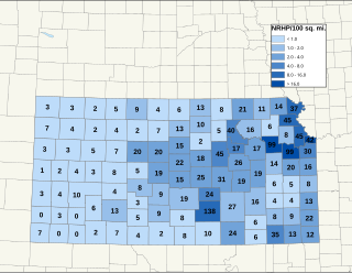
There are over 1,600 buildings, sites, districts, and objects in Kansas listed on the National Register of Historic Places in Kansas. NRHP listings appear in 101 of the state's 105 counties.
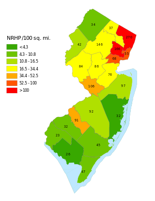
This is a list of properties and districts listed on the National Register of Historic Places in New Jersey. There are more than 1,700 listed sites in New Jersey. Of these, 58 are further designated as National Historic Landmarks. All 21 counties in New Jersey have listings on the National Register.
This National Park Service list is complete through NPS recent listings posted September 13, 2024.

The following is a list of Registered Historic Places in Keweenaw County, Michigan.
This National Park Service list is complete through NPS recent listings posted September 13, 2024.
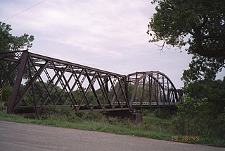
The Republican River Pegram Truss is a bridge located near Concordia, Kansas that is listed on the National Register of Historic Places. It is a three-span through truss bridge over the Republican River on route 795, northeast of Concordia. The bridge was built in 1893 by the Edge Moor Bridge Works of Wilmington, Delaware.
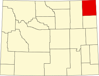
This is a list of the National Register of Historic Places listings in Crook County, Wyoming.

This is a list of the National Register of Historic Places listings in Johnson County, Wyoming. It is intended to be a complete list of the properties and districts on the National Register of Historic Places in Johnson County, Wyoming, United States. The locations of National Register properties and districts for which the latitude and longitude coordinates are included below, may be seen in an online map.

This is a list of the National Register of Historic Places listings in Todd County, Minnesota. It is intended to be a complete list of the properties and districts on the National Register of Historic Places in Todd County, Minnesota, United States. The locations of National Register properties and districts for which the latitude and longitude coordinates are included below, may be seen in an online map.

This is a list of the National Register of Historic Places listings in Kingman County, Kansas.

Canton Bridge Company was a firm that was later incorporated into the American Bridge Company. The firm was established in Canton, Ohio, in 1892 and became one of the nation's biggest bridge-builders during the early 20th century. It designed and/or built many bridges that later became listed on the U.S. National Register of Historic Places (NRHP).

The Wilson Pratt Truss Bridge is a Pratt Truss bridge over the Chapman creek near Chapman, Kansas that was built in 1904. It was listed on the National Register of Historic Places in 2009. It was built by the Canton Bridge Co. and is an excellent example of this type of bridge along with the nearby Chapman Creek Pratt Truss Bridge. The bridge spanning the creek is 90 feet (27 m) long. It has a wood deck. There are two additional approach spans on either side of the bridge for a total length of 165 feet (50 m). Due to its location on a dirt road, it has been mostly left alone and does not carry much traffic. It is also denoted as 21-HT-1 and as KSHS Inventory # 041-0000-0169.
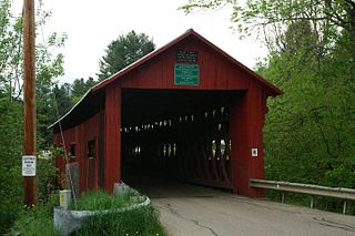
The Northfield Falls Covered Bridge, also called the Station Covered Bridge, is a wooden covered bridge that carries Cox Brook Road across the Dog River in Northfield, Vermont. Built in 1872, this Town lattice truss bridge is one of five surviving covered bridges in the town, and one of two that are visible from each other. It was listed on the National Register of Historic Places in 1974.
Four historic bridges on the Big Thompson River in Larimer County, Colorado survived its flood of 1976, but since have lost most of their historic integrity. They were built in 1933 and 1937. All four were listed on the National Register of Historic Places in 2002, and two were delisted in 2010.

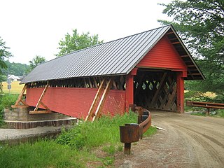
The Martin's Mill Covered Bridge is a wooden covered bridge spanning Lull's Brook on Martinsville Road in Hartland, Vermont. Built about 1880, it is one of two surviving 19th-century covered bridges in the town. It was listed on the National Register of Historic Places in 1973.

The Upper Falls Covered Bridge, also known as the Downers Covered Bridge, spans the Black River, carrying Upper Falls Road just south of Vermont Route 131 in western Weathersfield, Vermont. The Town lattice truss bridge was built in 1840 and rebuilt in 2008. Its gable ends are distinctive for their Greek Revival styling. The bridge was listed on the National Register of Historic Places in 1973.

The New Haven-Weybridge Rattling Bridge is a historic bridge spanning Otter Creek between the Vermont towns of Weybridge and New Haven. It connects Town Highway 7 in New Haven with Town Highway 11 in Weybridge. Built in 1908 by the American Bridge Company, it is a well-preserved example of a rivet-connected lattice truss bridge. It was listed on the National Register of Historic Places as Bridge 26 in 2006.
The River Road Covered Bridge was a historic covered bridge, carrying Veilleux Road across the Missisquoi River in Troy, Vermont. Built in 1910, the Town lattice truss was the only surviving covered bridge in Troy from the historic period of covered bridge construction when it burned on February 6, 2021. It also exhibited some distinctive variations in construction from more typical Town lattices. It was listed on the National Register of Historic Places in 1974.

The Crystal Springs Street–Dowagiac River Bridge is a road bridge that carries Crystal Springs Street over the Dowagiac River near Sumnerville, Michigan. It was installed in that location in 2017. Between 1938 and 2016, the bridge was located approximately 50 miles away, and carried M-86 over the Prairie River near Nottawa, Michigan, and was known then as the M-86–Prairie River Bridge. The bridge was listed on the National Register of Historic Places in 2000, and is the last remaining camelback pony truss bridge used on the state trunkline system in Michigan.
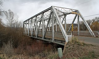
Gunnison River Bridge I and Gunnison River Bridge II are two 129 feet (39 m) long bridges built during 1926–27. They were separately listed on the National Register of Historic Places in 2002.

The Four Mile Creek Lattice is a historic bridge in rural Morris County, Kansas, located southeast of the community of Wilsey. The bridge, which was built circa 1890, carries a county road across Four Mile Creek. The single-span steel bridge is 35 feet (11 m) long. It has a lattice truss design, which is typified by smaller diagonal beams that form a lattice pattern; the design is also an example of a pony truss, where the trusses are above the roadbed but not connected at the top. Ornamental iron sunflowers adorn the sides of the bridge. While the bridge's builder is not documented, the design is similar to those of the Canton Bridge Company of Canton, Ohio, which also built many other bridges in Kansas during the period.


