
Bank Street is the major commercial north-south street in Ottawa, Ontario, Canada. It runs south from Wellington Street in downtown Ottawa, south through the neighbourhoods of Centretown, The Glebe, Old Ottawa South, Alta Vista, Hunt Club, and then through the villages of Blossom Park, Leitrim, South Gloucester, Greely, Metcalfe, Spring Hill, and Vernon before exiting the city limits at Belmeade Road.

Riverside Drive is a major road in Ottawa, Ontario, Canada that follows along the eastern bank of the Rideau River. Its northern terminus is at the Transitway/Via Rail underpass just south of the Queensway, and the road proceeds south to Limebank Road where it continues as River Road until the city limits. North of the Queensway, Riverside continues as Vanier Parkway, which travels through Vanier until Beechwood Avenue. The Vanier Parkway name is linked to Vanier, Ontario, which was named for former Governor General of Canada Georges Vanier.

Rideau Street is a major street in downtown Ottawa, Ontario, Canada and one of Ottawa's oldest and most famous streets running from Wellington Street in the west to Montreal Road in the east where it connects to the Vanier district. Rideau Street is home to the Château Laurier, the CF Rideau Centre and the Government Conference Centre. Along with Wellington Street and Sussex Drive it was among the first streets in Ottawa to be host to businesses; it was created with the founding of the early town. The Plaza Bridge by the Rideau Canal is at its westmost point and the Cummings Bridge is at its eastmost point.

Kent Street is a major street in downtown Ottawa, Ontario, Canada. One block west of Bank Street, Kent is one way running north. It begins at the Queensway at the south and ends at Wellington Street. The street has fewer storefronts than Bank Street. South of downtown it is mainly small and medium-sized office buildings, with some restaurants and residences. The northern part of the street is home to several large office towers, mainly governmental. It was originally known as Hugh Street.
King's Highway 17, more commonly known as Highway 17, is a provincially maintained highway and the primary route of the Trans-Canada Highway through the Canadian province of Ontario. It begins at the Manitoba boundary, 50 km (31 mi) west of Kenora, and the main section ends where Highway 417 begins just west of Arnprior. A small disconnected signed section of the highway still remains within the Ottawa Region between County Road 29 and Grants Side Rd. This makes it Ontario's longest highway.
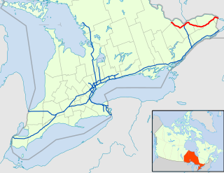
King's Highway 7, commonly referred to as Highway 7 and historically as the Northern Highway, is a provincially maintained highway in the Canadian province of Ontario. At its peak, Highway 7 measured 716 km (445 mi) in length, stretching from Highway 40 east of Sarnia in Southwestern Ontario to Highway 17 west of Ottawa in Eastern Ontario. However, due in part to the construction of Highways 402 and 407, the province transferred the sections of Highway 7 west of London and through the Greater Toronto Area to county and regional jurisdiction. The highway is now 535.7 km (332.9 mi) long; the western segment begins at Highway 4 north of London and extends 154.1 km (95.8 mi) to Georgetown, while the eastern segment begins at Donald Cousens Parkway in Markham and extends 381.6 km (237.1 mi) to Highway 417 in Ottawa.
Baseline Road is a road in Ottawa, Ontario, Canada.
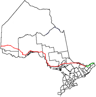
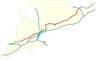
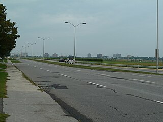
King's Highway 417, commonly referred to as Highway 417 and the Queensway through Ottawa, is a 400-series highway in the Canadian province of Ontario. It connects Ottawa with Montreal, and is the backbone of the transportation system in the National Capital Region. Within Ottawa, it forms part of the Queensway west from Highway 7 to Ottawa Regional Road 174. Highway 417 extends from the Quebec border to Arnprior, where it continues westward as Highway 17. Aside from the urban section through Ottawa, Highway 417 passes through farmland that dominates much of the fertile Ottawa Valley.

Carling Avenue is a major east–west arterial road in the west end of Ottawa, Ontario, Canada. It runs from March Road in Kanata to Bronson Avenue in the Glebe. The road is named for John Carling, founder of Carling Brewery and Conservative MP and Senator, Postmaster General and Minister of Agriculture.

Hintonburg is a neighbourhood in Kitchissippi Ward in Ottawa, Ontario, Canada, located west of the Downtown core. It is a historically working-class, predominantly residential neighbourhood, with a commercial strip located along Wellington Street West. It is home to the Parkdale Farmer's Market, located along Parkdale Avenue, just north of Wellington.

Elgin Street is a street in the Downtown core of Ottawa, Ontario, Canada. Originally named Biddy's Lane, it was later named after Lord Elgin.

The Sir John A. Macdonald Parkway, formerly the Ottawa River Parkway, is a four-lane scenic parkway along the Ottawa River in Ottawa, Ontario, Canada. It runs from Carling Avenue near Connaught Avenue, to Booth Street at the Canadian War Museum and National Holocaust Monument. It is maintained by the National Capital Commission. The speed limit is 60 km/h (37 mph). Bicycles are allowed on the road and on a parallel recreational path along the parkway.
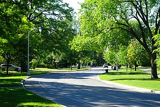
Island Park Drive is an important and scenic north-south thoroughfare in Ottawa, Ontario, Canada with a length of about 4 km. It is one of several parkways in Ottawa administered by the National Capital Commission providing scenic routes throughout Canada's capital region.

Dwyer Hill Road is the longest road within the municipal jurisdiction of the city of Ottawa, Ontario, Canada.

Nicholas Street is an arterial road in the central area of Ottawa, Ontario which connects Highway 417 with the downtown core. Despite being a municipal road, the street is designated as part of Canada's National Highway System, as part of an interconnecting route between Highway 417 and Quebec Autoroute 5 in Gatineau.
King Edward Avenue is a major thoroughfare in the eastern part of Ottawa, Ontario, Canada. Despite being a municipal road, a portion of the street is designated as part of Canada's National Highway System, as part of an interconnecting route between Ontario Highway 417 in Ottawa and Quebec Autoroute 5 in Gatineau.

Metcalfe Street is a downtown arterial road in Ottawa, Ontario, Canada. It is named for Charles Theophilus Metcalfe, a nineteenth-century Governor General of the Province of Canada. It is a north-south route, operating one way northbound, providing a key thoroughfare from Highway 417. In the late 19th century and the early 20th century, it was one of the most prestigious addresses in Ottawa being home address of Ottawa's mayor Thomas Birkett, Canada's lumber and railroad baron John Rudolphus Booth, inventor Thomas Willson a.k.a. Carbide Willson, and Sir Alexander Campbell, law partner of Sir John A. Macdonald.
Highway 17B was formerly the highway designation for six business routes of Highway 17, the main route of the Trans-Canada Highway through the Canadian province of Ontario. Each was the original route of Highway 17 through the town or city that it served, and was subsequently given the 17B designation when a newer bypass route was constructed to reduce traffic pressure on the urban street network.
Parkdale Avenue is an arterial road located west of downtown Ottawa, Ontario, Canada. It runs in a north-south direction between the Sir John A. Macdonald Parkway and Carling Avenue in the Hintonburg and Civic Hospital neighbourhoods. It is an extremely busy road providing access to Tunney's Pasture, the Parkdale Market, the Ottawa Civic Hospital, and the Central Experimental Farm. Furthermore, it has direct connections to other major east-west arteries such as Scott Street, Wellington Street West, Gladstone Avenue, and Highway 417.
