
Sparks Street is a pedestrian mall in Ottawa, Ontario, Canada. It was a main street in Ottawa that was converted into an outdoor pedestrian street in 1967, making it the earliest such street or mall in Canada.

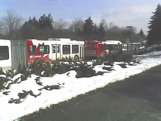
The Transitway is a bus rapid transit (BRT) network operated by OC Transpo in Ottawa, Ontario, Canada. It comprises a series of bus-only roadways and reserved lanes on city streets and highways. The dedicated busways ensure that buses and emergency vehicles on the Transitway rarely intersect directly with the regular traffic, and make it possible for them to continue at full speed even during rush hour. OC Transpo operates a network of rapid routes which use the Transitway to connect communities with the O-Train light rail system. Additional bus routes also use segments of the Transitway.
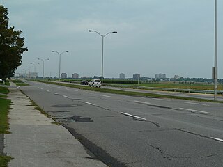
Baseline Road is a road in Ottawa, Ontario, Canada.
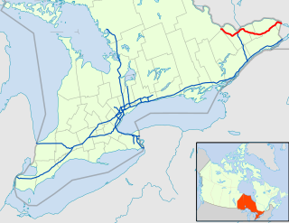
King's Highway 417, commonly referred to as Highway 417 and the Queensway through Ottawa, is a 400-series highway in the Canadian province of Ontario. It connects Ottawa with Montreal via A-40, and is the backbone of the transportation system in the National Capital Region. Within Ottawa, it forms part of the Queensway west from Highway 7 to Ottawa Road 174. Highway 417 extends from the Quebec border, near Hawkesbury, to Arnprior, where it continues westward as Highway 17. Aside from the urban section through Ottawa, Highway 417 passes through farmland that dominates much of the fertile Ottawa Valley.

Downtown Ottawa is the central area of Ottawa, Ontario, Canada. Like other downtowns it is the commercial and economic centre of the city. It is sometimes referred to as the Central Business District and contains Ottawa's financial district. It is bordered by the Ottawa River to the north, the Rideau Canal to the east, Gloucester Street to the south and Bronson Avenue to the west. This area and the residential neighbourhood to the south are also known locally as 'Centretown'. The total population of the area is 4,876.

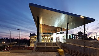
uOttawa is a light rail transit (LRT) station on the O-Train Confederation Line, located on the University of Ottawa campus.
Bayview is an O-Train interchange station in Ottawa, Ontario, Canada, connecting the Confederation Line and Trillium Line.

Ottawa station, or Ottawa Train Station, is the main inter-city train station in Ottawa, Ontario, Canada, operated by Via Rail. It is located 4 kilometres (2.5 mi) east of downtown Ottawa and adjacent to Tremblay O-Train station in the neighbourhood of Eastway Gardens. The station serves inter-city trains connecting to Toronto, Kingston, Montreal and Quebec City on Via Rail's Corridor Route.
Dominion is a station on the transitway in Ottawa, Ontario. It is located north of the western edge of Westboro village, where the below-grade transitway segment joins the Sir John A. Macdonald Parkway. The station is named after nearby Dominion Avenue.

Cyrville is a station on the Confederation Line of Ottawa's O-Train light metro system, located at Cyrville Road and near the Queensway.
Bayshore is a station on Ottawa, Ontario, Canada's transitway served by OC Transpo buses. It is located in the western transitway section at the Bayshore Shopping Centre in the neighbourhood of Bayshore.
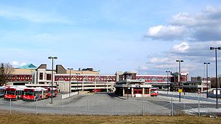
Stittsville Transitway Station is a bus-stop on Ottawa, Ontario's transitway served by OC Transpo buses. It located on Shea Road at the Goulbourn Recreation Complex in Stittsville, Ontario.

Boulevard Maisonneuve is an important arterial in the heart of Downtown Gatineau, Quebec. It serves as connector route between the Portage Bridge from Ottawa to Quebec Autoroutes 5 and 50 as well as Boulevard Fournier towards the Gatineau sector of the city, northern portions of the Hull sector and the northern east suburbs. It also gives access to the Macdonald-Cartier Bridge and the Alexandra Bridge.

Ottawa Central Station is the main inter-city bus station in Ottawa, Ontario, Canada. It is located 1.5 km south of downtown Ottawa in the Centretown neighbourhood and serves buses from Ontario Northland and Autobus Gatineau.
Jeanne d'Arc station is a stop on Ottawa's Transitway. It is located at the interchange of Regional Road 174 and Jeanne d'Arc Boulevard in Orleans in the east end of the city of Ottawa.

Metcalfe Street is a downtown arterial road in Ottawa, Ontario, Canada. It is named for Charles Theophilus Metcalfe, a nineteenth-century Governor General of the Province of Canada. It is a north-south route, operating one way northbound, providing a key thoroughfare from Highway 417. In the late 19th century and the early 20th century, it was one of the most prestigious addresses in Ottawa being home address of Ottawa's mayor Thomas Birkett, Canada's lumber and railroad baron John Rudolphus Booth, inventor Thomas Willson a.k.a. Carbide Willson, and Sir Alexander Campbell, law partner of Sir John A. Macdonald.

Parkdale Avenue is an arterial road located west of downtown Ottawa, Ontario, Canada. It runs in a north-south direction between the Sir John A. Macdonald Parkway and Carling Avenue in the Hintonburg and Civic Hospital neighbourhoods. It is an extremely busy road providing access to Tunney's Pasture, the Parkdale Market, the Ottawa Civic Hospital, and the Central Experimental Farm. Furthermore, it has direct connections to other major east-west arteries such as Scott Street, Wellington Street West, Gladstone Avenue, and Highway 417.

The Confederation Line, also called O-Train Line 1, is a light rail line operated by OC Transpo in Ottawa, Ontario, Canada, as part of the city's O-Train light rail system. The Confederation Line opened on September 14, 2019; it is the second O-Train line opened, operating on an east to west route, including under Queen Street in the downtown core, to complement the north to south Trillium Line which operates to the west of the downtown core. Using light rail rolling stock and technology, the Confederation Line is completely grade separated.
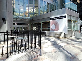
Parliament is a station on the Confederation Line as part of the O-Train network in Ottawa, Ontario, Canada. The station is located under O'Connor and Queen Streets in Downtown Ottawa. It has the highest projected use of all new stops on the Confederation Line, with access to Parliament Hill, Sparks Street, the downtown business district, as well as the World Exchange Plaza and Bank Street. The station is also near the CBC Ottawa Production Centre studios.

Lyon is an underground light rail station on the Confederation Line of the O-Train in Ottawa located in the western portion of Ottawa's downtown, specifically at Lyon Street and Queen Street, the latter being the street the line runs under within Ottawa's downtown core.
