Old Village Historic District (Monroe, Michigan)

Last updated
Old Village Historic District
MonroeDowntown.jpg
Looking south along Monroe Street (M-125)
USA Michigan location map.svg
Red pog.svg
Location within the state of Michigan
Usa edcp location map.svg
Red pog.svg
Location within the United States
Location Monroe, Michigan
Coordinates 41°54′45″N83°24′00″W / 41.91250°N 83.40000°W / 41.91250; -83.40000
NRHP reference No. 82002854 [1]
Added to NRHPMay 6, 1982

The Old Village Historic District is a commercial and residential historic district consisting of the downtown area of the city of Monroe in Monroe County, Michigan. The district was listed as a Michigan Historic Site [2] and added to the National Register of Historic Places on May 6, 1982. [1]

Contents

The area is commonly referred to as the downtown area and is the oldest settled area in Monroe, dating back to 1817 when the area was first platted. Some of the oldest surviving buildings in this district date back to 1830, and the district incorporates several different architectural styles. The stretch of the district that runs along M-125 is also designated as one of the Pure Michigan Byways. [3]

History

The area dates back to 1817 when the first roads were drawn out on a piece of land given by local landowner Joseph Loranger for the establishment of the village for the newly organized Monroe County. The grid plan, drawn up by Henry Disbrow, was modeled after the system used in New York City, with streets named after numbers. Although small at first, the city grew rapidly along the River Raisin beginning around 1830. [4] While much of the growing population began spreading throughout Monroe County, the majority lived within the Old Village where the center of government and industry resided. The current county courthouse was built in 1880, although the plot of land it is located on has housed the seat of the county government since 1817. Monroe opened its first post office in 1913. The main industry at the time was Monroe's numerous paper mills along the River Raisin. [4] The Dundee Historic District in Dundee was settled further up the river around the same time, and the two heavily relied on the river and built several dams along its course. [5]

The Navarre-Anderson Trading Post, built in 1789, was originally part of the Old Village along the River Raisin. However, development in the area threatened the historic structure, and it was moved in 1894 and again in 1971. Today, it is far removed from the rest of the Old Village. [6] The Sawyer House was built in 1873 and is located at 320 East Front Street within the Old Village Historic District. [7]

On July 4, 1910, then-President William Howard Taft and Elizabeth Bacon Custer unveiled a statue to commemorate George Armstrong Custer, who spent much of his early life living in Monroe. The statue was located in the middle of the intersection of East First Street and Washington Street in the Old Village. [8] This was during a time when automobile traffic in Monroe was very light. However, with the increase of automobile traffic, the statue's location in the middle of an intersection warranted protests as a traffic hazard. On June 20, 1923, the city moved the statue out of the Old Village to a less prominent location along the River Raisin, where it remained until it was moved again in August 1955 to its current location on the other side of the river from the Old Village. [9] Today, the statue is listed on the National Register of Historic Places as the George Armstrong Custer Equestrian Monument.

The district has seen little redevelopment or expansion since the 1930s. In the 1960s, several older buildings within the district were demolished to make way for new modern buildings and parking lots, as the district was seen as old fashioned and unable to keep with the demands of new industries and growing populations. [4]

Present day

Today, the district itself centers around M-125 and M-50, [10] known locally as Monroe Street and Front Street respectively, and extends for several blocks east and south. [1] [2] The district is roughly bounded by the River Raisin on the north, 7th Street on the south, and Navarre Street on the east. [2] [11]

Most of the major businesses and industries began moving to the more spacious outer core of Monroe. Today, the center of government and law enforcement within Monroe remains in the Old Village. The row buildings along Monroe Street consist of small businesses on the ground level and apartments and offices on the second and third floors. [2] The outer areas of the Old Village include the city hall, post office, county courthouse and jail, various small businesses, Monroe Middle School, a food-packaging plant, and larger houses. The Old Village remains an active part of Monroe's economy, although the majority of businesses have moved elsewhere in the city. [4] The Old Village Historic District is located directly across the river from the East Elm-North Macomb Street Historic District and the St. Mary's Church Complex Historic District.

Historic images

Modern images

Related Research Articles

<span class="mw-page-title-main">Monroe County, Michigan</span> County in Michigan, United States

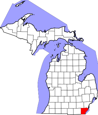
Monroe County is a county in the U.S. state of Michigan. As of the 2020 Census, the population was 154,809. The largest city and county seat is Monroe. The county was established as the second county in the Michigan Territory in 1817 and was named for then-President James Monroe.

<span class="mw-page-title-main">Frenchtown Charter Township, Michigan</span> Charter township in Michigan, United States

Frenchtown Charter Township is a charter township within Monroe County in the U.S. state of Michigan. The population was 20,428 at the 2010 census.

<span class="mw-page-title-main">Maybee, Michigan</span> Village in Michigan, United States

Maybee is a village in Monroe County in the U.S. state of Michigan. The population was 545 at the 2020 census. The village is located within Exeter Township. Maybee was established in 1873 and incorporated as a village in 1899.

<span class="mw-page-title-main">Monroe, Michigan</span> City in Michigan, United States

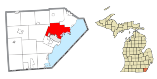
Monroe is the largest city and county seat of Monroe County, Michigan, United States. The population was 20,462 as of the 2020 census. The city is bordered on the south by Monroe Charter Township, but the two are administered autonomously. Monroe is the core city in the Monroe metropolitan area, which is coterminous with Monroe County and had a population of 154,809 in 2020. Located on the western shores of Lake Erie approximately 14 miles (23 km) north of Toledo, Ohio and 25 miles (40 km) south of Detroit, the city is part of the Detroit–Ann Arbor–Flint combined statistical area.

<span class="mw-page-title-main">Raisinville Township, Michigan</span> Civil township in Michigan, United States

Raisinville Township is a civil township of Monroe County in the U.S. state of Michigan. The population was 5,816 at the 2010 census.

<span class="mw-page-title-main">River Raisin</span> River in southeastern Michigan, United States

The River Raisin is a river in southeastern Michigan, United States, that flows through glacial sediments into Lake Erie. The area today is an agricultural and industrial center of Michigan. The river flows for almost 139 miles (224 km), draining an area of 1,072 square miles (2,780 km2) in the Michigan counties of Lenawee, Washtenaw, Jackson, Hillsdale, and Monroe County, where its mouth at Lake Erie is located. French settlers named it as La Rivière aux Raisins because of the wild grapes growing along its banks, the French word for grape being raisin. The French term for "raisin" is raisin sec.

<span class="mw-page-title-main">M-50 (Michigan highway)</span> State highway in Michigan, United States

M-50 is a state trunkline highway in the US state of Michigan. Although designated as an east–west highway, it is nearly a diagonal northwest–southeast route. The western terminus is at exit 52 along Interstate 96 (I-96) near Alto a few miles east of the metro Grand Rapids area, and its eastern terminus is in downtown Monroe at US Highway 24. In between the trunkline runs through seven counties of the southern part of the Lower Peninsula mostly through rural farm fields and small communities. The highway also runs through downtown Jackson to connect between two freeway sections of US 127. In the Irish Hills area of the state southeast of Jackson, M-50 runs next to Michigan International Speedway.

<span class="mw-page-title-main">Sandy Creek (Michigan)</span> River in Michigan, United States

Sandy Creek is an 18.5-mile-long (29.8 km) creek located entirely within Monroe County in the U.S. state of Michigan. The creek rises in London Township in the north-central portion of the county and flows southeast into Lake Erie in Frenchtown Charter Township at Sterling State Park.

<span class="mw-page-title-main">National Register of Historic Places listings in Monroe County, Michigan</span>

This is a list of the National Register of Historic Places listings in Monroe County, Michigan.

<span class="mw-page-title-main">River Raisin National Battlefield Park</span> United States historic place

The River Raisin National Battlefield Park preserves the site of the Battle of Frenchtown as the only national battlefield marking a site of the War of 1812. It was established as the 393rd unit of the United States National Park Service under Title VII of the Omnibus Public Land Management Act, which was signed into law on March 30, 2009. The park is located in the city of Monroe in Monroe County, Michigan. It was designated as a Michigan Historic Site on February 18, 1956 and was added to the National Register of Historic Places on December 10, 1982. The house at 1403 East Elm Avenue was added to the National Register listing in 2019. It officially began operation as a national park unit on October 22, 2010.

<span class="mw-page-title-main">George Armstrong Custer Equestrian Monument</span> Statue in Monroe, Michigan, United States

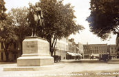
The George Armstrong Custer Equestrian Monument, also known as Sighting the Enemy, is an equestrian statue of General George Armstrong Custer located in Monroe, Michigan. The statue, sculpted by Edward Clark Potter, was designated as a Michigan Historic Site on June 15, 1992 and soon after listed on the National Register of Historic Places on December 9, 1994.

<span class="mw-page-title-main">East Elm–North Macomb Street Historic District</span> Historic district in Michigan, United States

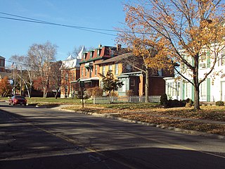
The East Elm–North Macomb Street Historic District is a residential historic district located in the city of Monroe in Monroe County, Michigan. The district was listed as a Michigan Historic Site and added to the National Register of Historic Places on May 6, 1982.

<span class="mw-page-title-main">Governor Robert McClelland House</span> Historic house in Michigan, United States

The Governor Robert McClelland House is a private residence located at 47 East Elm Avenue in the city of Monroe in Monroe County, Michigan. It was listed as a Michigan Historic Site on March 3, 1971, and it was the first property in the county to be listed on the National Register of Historic Places on September 3, 1971.

<span class="mw-page-title-main">Sawyer House (Monroe, Michigan)</span> Historic house in Michigan, United States

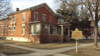
The Sawyer House, also known as the Sawyer Homestead and in its previous incarnation as the Navarre House, is a city-owned house located at 320 East Front Street in Monroe, Michigan. It was listed as a Michigan Historic Site on June 19, 1975. The house was listed on the National Register of Historic Places on November 23, 1977, and is also part of the larger Old Village Historic District.

<span class="mw-page-title-main">Navarre–Anderson Trading Post</span> United States historic place

The Navarre–Anderson Trading Post is a former trading post complex located at 3775 North Custer Road in Frenchtown Charter Township along the River Raisin in Monroe County, Michigan. It was listed as a Michigan Historic Site on June 16, 1972 and also listed on the National Register of Historic Places on July 31, 1972.

<span class="mw-page-title-main">St. Mary's Church Complex Historic District (Monroe, Michigan)</span> Historic church in Michigan, United States

The St. Mary's Church Complex Historic District is a historic district located at the junction of Elm Avenue and North Monroe Street (M-125) in the city of Monroe, Michigan. It was listed as a Michigan Historic Site and added to the National Register of Historic Places on May 6, 1982.

<span class="mw-page-title-main">Weis Manufacturing Company building</span> United States historic place

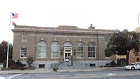
The Weis Manufacturing Company, currently known as WoodCraft Square, is a former factory located at 800 West 7th Street in the city of Monroe in Monroe County, Michigan. It was listed as a Michigan Historic Site and added to the National Register of Historic Places on October 26, 1981.

<span class="mw-page-title-main">Dundee Historic District</span> Historic district in Michigan, United States

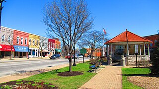
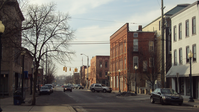
The Dundee Historic Village is a historic district located in Dundee, Michigan. The district was added to the National Register of Historic Places on August 20, 1990. This area is commonly referred to as the downtown area of Dundee and was settled almost concurrently with the Old Village Historic District in nearby Monroe. Both were built in their respective locations due to the River Raisin. Originally, the buildings within the district were small, wood buildings, but these were eventually replaced with two-story, brick storefronts. Most of the surviving buildings were built between 1866 and 1900, although the district traces its origins to Dundee's establishment in 1825.

<span class="mw-page-title-main">Old Mill Museum (Dundee, Michigan)</span> United States historic place

The Old Mill Museum, also known as the Alfred Wilkerson Grist Mill, is a historic structure located along the River Raisin at 242 Toledo Street in Dundee, Michigan. It was designated as a Michigan Historic Site on August 3, 1979. It was later listed as a contributing property within the Dundee Historic District, which was added to the National Register of Historic Places on August 20, 1990.

<span class="mw-page-title-main">Bridge School (Michigan)</span> Historic site in Raisinville Township, Michigan

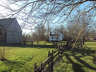
The Bridge School is a former school building located in rural Raisinville Township in the U.S. state of Michigan. It is recognized as the first public school in the Territory of Michigan when it was founded in 1828. The school district closed in 1946, and the building has served as Raisinville Township Hall since 1982. The Bridge School was listed as a Michigan State Historic Site on December 17, 1987.

References

  1. 1 2 3 "National Register Information System". National Register of Historic Places. National Park Service. November 11, 2009.
  2. 1 2 3 4 State of Michigan (2001–2003). "Old Village Historic District". Archived from the original on 2011-06-06. Retrieved November 15, 2009.
  3. "Interactive Heritage Route Listing". Michigan Department of Transportation. 2001–2009. Retrieved November 14, 2009.
  4. 1 2 3 4 Old Village Plat Neighborhood Association (6 Apr 2007). "The History of the Old Village Plat of Monroe, Michigan" . Retrieved November 18, 2009.
  5. Village of Dundee (2009). "Dundee Village: History". Archived from the original on July 23, 2011. Retrieved November 23, 2009.
  6. Smith, David (2004–2006). "Monroe County Michigan Museum: Navarre Anderson Trading Post Complex" . Retrieved November 18, 2009.
  7. State of Michigan (2001–2003). "Sawyer House". Archived from the original on June 6, 2011. Retrieved November 15, 2009.
  8. New York Times (15 May 1910). "President Will Help Dedicate the Custer Monument" (PDF). New York Times. Retrieved April 3, 2009.
  9. Monroe County Library System (2009). "Custer Statue Had Three Sites During Tenure in City". Archived from the original on June 8, 2011. Retrieved November 14, 2009.
  10. When the district was first designated on May 6, 1982, Front Street was known as M-50 and may appear named as such on certain lists and maps. However, in October 2006, M-50's eastern terminus was truncated 1.17 miles (0.66 km) from M-125 to US-24. The current road that runs through the Old Village Historic District is now under local control under the name Front Street.
    See, Bessert, Chris (1997–2009). Michigan Highways: Highways 50 to 59, accessed November 12, 2009.
  11. "Old Village Historic District". Google Maps . 2009. Retrieved November 16, 2009.