Olivia, Pennsylvania

Last updated

Olivia, Pennsylvania
USA Pennsylvania location map.svg
Red pog.svg
Olivia
Usa edcp location map.svg
Red pog.svg
Olivia
Coordinates: 40°42′49″N78°12′09″W / 40.71361°N 78.20250°W / 40.71361; -78.20250
CountryUnited States
State Pennsylvania
County Blair
Township Snyder
Area
[1]
  Total
0.09 sq mi (0.22 km2)
  Land0.09 sq mi (0.22 km2)
  Water0.00 sq mi (0.00 km2)
Elevation
[2]
1,047 ft (319 m)
Population
 (2020) [3]
  Total
66
  Density776.47/sq mi (301.32/km2)
Time zone UTC-5 (Eastern (EST))
  Summer (DST) UTC-4 (EDT)
ZIP Code
16686 (Tyrone)
Area code(s) 814/582
FIPS code 42-56761
GNIS feature ID2805535 [2]

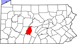
Olivia is an unincorporated community and census-designated place (CDP) in Blair County, Pennsylvania, United States. It was first listed as a CDP prior to the 2020 census. [2]

Contents

The CDP is in northern Blair County, in the northeastern part of Snyder Township, along the north side of South Eagle Valley Road (old U.S. Route 220). It is 3.5 miles (5.6 km) northeast of Tyrone and 1.5 miles (2.4 km) southwest of Bald Eagle. The community is on the north side of the valley of Bald Eagle Creek, which flows southwestward to join the Little Juniata River in Tyrone.

Demographics

Historical population
CensusPop.Note
2020 66
U.S. Decennial Census [4]

Education

The school district is the Tyrone Area School District. [5]

Related Research Articles

<span class="mw-page-title-main">Blair County, Pennsylvania</span> County in Pennsylvania, United States

Blair County is a county in the Commonwealth of Pennsylvania. As of the 2020 census, the population was 122,822. Its county seat is Hollidaysburg, and its largest city is Altoona. The county was created on February 26, 1846, from parts of Huntingdon and Bedford counties. The county is part of the Southwest Pennsylvania region of the state.

<span class="mw-page-title-main">Snyder Township, Blair County, Pennsylvania</span> Township in Pennsylvania, United States

Snyder Township is a township in Blair County, Pennsylvania, United States. It is part of the Altoona, PA Metropolitan Statistical Area. The population was 3,345 at the 2020 census.

<span class="mw-page-title-main">Tyrone, Pennsylvania</span> Borough in Pennsylvania, United States

Tyrone is a borough in Blair County, Pennsylvania, United States, located 15 miles (24 km) northeast of Altoona, on the Little Juniata River. Tyrone was of considerable commercial importance in the twentieth century. It was an outlet for the Clearfield coal fields and was noted for manufacturing paper products. There were planing mills and chemical and candy factories. In 1900, 5,847 people lived here; in 1910, 7,176; and in 1940, 8,845 people resided here. The population was 5,477 at the 2010 census. It is part of the Altoona, PA Metropolitan Statistical Area. It was named after County Tyrone in Ireland.

<span class="mw-page-title-main">Saylorsburg, Pennsylvania</span> Census-designated place in Pennsylvania, United States

Saylorsburg is a census-designated place and unincorporated community in Monroe County, Pennsylvania, United States. Saylorsburg is located off Pennsylvania Route 33, 5 miles (8.0 km) northwest of Wind Gap. As of the 2010 census, its population was 1,126. The village is located in both Ross Township and Hamilton Township.

Charlottsville is an unincorporated community and census-designated place (CDP) in Blair County, Pennsylvania, United States. It was first listed as a CDP prior to the 2020 census.

East Altoona is an unincorporated community and census-designated place (CDP) in Blair County, Pennsylvania, United States. It was first listed as a CDP prior to the 2020 census.

Elberta is an unincorporated community and census-designated place (CDP) in Blair County, Pennsylvania, United States. It was first listed as a CDP prior to the 2020 census.

Eldorado is an unincorporated community and census-designated place (CDP) in Blair County, Pennsylvania, United States. It was first listed as a CDP prior to the 2020 census.

Fostoria is an unincorporated community and census-designated place (CDP) in Blair County, Pennsylvania, United States. It was first listed as a CDP prior to the 2020 census.

<span class="mw-page-title-main">Geeseytown, Pennsylvania</span> Census-designated place in Pennsylvania, United States

Geeseytown is an unincorporated community and census-designated place (CDP) in Blair County, Pennsylvania, United States. It was first listed as a CDP prior to the 2020 census.

Gray is an unincorporated community and census-designated place (CDP) in Blair County, Pennsylvania, United States. It was first listed as a CDP prior to the 2020 census.

Ironville is an unincorporated community and census-designated place (CDP) in Blair County, Pennsylvania, United States. It was first listed as a CDP prior to the 2020 census.

Nealmont is an unincorporated community and census-designated place (CDP) in Blair County, Pennsylvania, United States. It was first listed as a CDP prior to the 2020 census.

Sickles Corner is an unincorporated community and census-designated place (CDP) in Blair County, Pennsylvania, United States. It was first listed as a CDP prior to the 2020 census.

Tyrone Forge is an unincorporated community and census-designated place (CDP) in Blair County, Pennsylvania, United States. It was first listed as a CDP prior to the 2020 census.

Vail is an unincorporated community and census-designated place (CDP) in Blair County, Pennsylvania, United States. It was first listed as a CDP prior to the 2020 census.

Continental Courts is a mobile home park and census-designated place (CDP) in Centre County, Pennsylvania, United States. It was first listed as a CDP prior to the 2020 census.

Eagle Creek is a census-designated place (CDP) in Centre County, Pennsylvania, United States. It was first listed as a CDP prior to the 2020 census.

Holters Crossing is an unincorporated community and census-designated place (CDP) in Centre County, Pennsylvania, United States. It was first listed as a CDP prior to the 2020 census.

Clintondale is an unincorporated community and census-designated place (CDP) in Clinton County, Pennsylvania, United States. It was first listed as a CDP prior to the 2020 census.

References

  1. "ArcGIS REST Services Directory". United States Census Bureau. Retrieved October 12, 2022.
  2. 1 2 3 U.S. Geological Survey Geographic Names Information System: Olivia, Pennsylvania
  3. "Census Population API". United States Census Bureau. Retrieved October 12, 2022.
  4. "Census of Population and Housing". Census.gov. Retrieved June 4, 2016.
  5. "2020 CENSUS - SCHOOL DISTRICT REFERENCE MAP: Blair County, PA" (PDF). U.S. Census Bureau . Retrieved December 22, 2024. - Text list