
The following outline is provided as an overview of and topical guide to Burkina Faso:
Contents
- General reference
- Geography of Burkina Faso
- Location
- Environment of Burkina Faso
- Regions of Burkina Faso
- Demography of Burkina Faso
- Government and politics of Burkina Faso
- Branches of government
- Foreign relations of Burkina Faso
- Law and order in Burkina Faso
- Military of Burkina Faso
- History of Burkina Faso
- Culture of Burkina Faso
- Art in Burkina Faso
- Sports in Burkina Faso
- Economy and infrastructure of Burkina Faso
- Education in Burkina Faso
- Health in Burkina Faso
- See also
- References
- External links
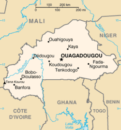
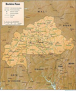
Burkina Faso – landlocked sovereign country located in West Africa. [1] It is surrounded by six countries: Mali to the north, Niger to the east, Benin to the south east, Togo, Ghana to the south, and Côte d'Ivoire to the south west. Formerly called the Republic of Upper Volta , it was renamed on August 4, 1984, by President Thomas Sankara to mean "the land of upright people" in Mooré and Dioula, the major native languages of the country. Literally, "Burkina" may be translated, "men of integrity," from the Moré language, and "Faso" means "father's house" in Dioula.