Wildlife of Burkina Faso

Last updated

Savanna, west of Ouagadougou, typical of the majority of the country's landscape. Savannaburkina.jpg
Savanna, west of Ouagadougou, typical of the majority of the country's landscape.
Location of Burkina Faso Location Burkina Faso AU Africa.svg
Location of Burkina Faso

Burkina Faso is largely wild bush country with a mixture of grass and small trees in varying proportions. The savanna region is mainly grassland in the rainy season and semi desert during the harmattan period (defined as the period when stormy and dusty Sahara winds blow dry and hot). Fauna, one of the most diverse in West Africa, includes the elephant, hippopotamus, buffalo, monkey, lions, crocodile, giraffe, various types of antelope, and a vast variety of bird and insect life. [1] The country has 147 mammal species, 330 aquatic species including 121 species of fish and 2067 different plant species. [2] Of the plant species, the dominant endemic species are shea tree (Butyrospermum parkii) and the baobab, the former plant species has immense economic value to the country. [1] [3]

Contents

To ensure conservation and preservation of the wildlife of Burkina Faso, four national parks have been established. These are the Po National Park in the south-centre of the country, Arli National Park established in 1954 in the southeast, W of the Niger National Park, a trans frontier park existing since 1957 in the east bordering Benin and Niger and the Deux Balés National Park. The forests, fauna and fish have been declared part of the national estate of Burkina Faso. [1] [4] In addition, the List of national parks of Burkina Faso consist of one UNESCO Biosphere reserve, three complete reserves, six partial reserves and ten protected forests. However, according to conservation classification conducted between 1936 and 1957, the country has 78 protected areas that cover 38,369 km2 (14,814 sq mi), which accounts to about 14% of the area of the country. [5]

Geography

Lalgaye.JPG
Landscape at Lalgaye
Arli National Park Burkina Faso.png
Arli National Park
Mekrou river in W-National Park MS 6380.JPG
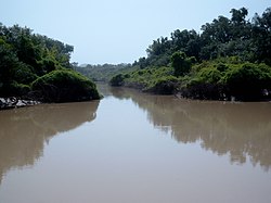
The Mékrou River near Point Triple in the W National Park during the rainy season.

Wildlife area in the landlocked Burkina Faso in western Africa is spread over a plateau area of 270,764 km2 (104,543 sq mi). The dominant habitat types are the grassy savanna in the north with transition to the varying thin forests in the south. [1]

Based on ecological characteristics and climatic conditions, the country is divided under three bio-climatic zones namely, the Sahelian Zone, the Sudanian Zone and the Sudano-Guinean Zone. The Sahelian Zone covers 25% of the area of the northern part of the country, which is further subdivided under the Sahelian and sub-Sahelian sectors. In the Sahelian sector, where the rainfall is only of the order of 400 millimetres (16 in), the vegetation is mostly of shrubs and wooded grassland or steppe. The sub-Sahelian sector represents the transition zone, receives an average annual rainfall of 400–600 millimetres (16–24 in) and represents the transition between the Sahelian and Sudanian bioclimatic zones. The vegetation in this sector has moist Sudan savanna vegetation in the river valleys, while the western half is largely inhabited by humans; most of the large trees in the northern half of the sector are reported to have vanished due to climate change. The Sudan Zone receives higher rainfall in the range of 600–1,000 millimetres (24–39 in) and is further subdivided into three sectors namely, the central plateau sector, the Mouhoun sector and the Pendjari–Mékrou sector and has widely varying vegetation depending on human occupation for agriculture and mostly savanna vegetation, predominantly wooded savanna. the Pendjari–Mékrou sector with its floodplains and many ephemeral rivers, is less populated by humans but has the largest population of mammals in the country; vultures and raptors are also reported. The Sudano-Guinean Zone in the southwest corner of the country is a humid zone with an annual rainfall in the range of 1,000–1,200 millimetres (39–47 in). It is heavily wooded with wooded savannas and gallery forests; it has the ambience of a park with its widespread vegetation of Khaya senegalensis , Daniellia oliveri and Isoberlinia forests, tall grasses and savanna vegetation is also a dominant feature. Its human population distribution is low but the wildlife population is the second largest in the country. [5]

The area is drained by many rivers, the most important of them being the Black Volta (Mouhoun), the Red Volta (Nazinon), and the White Volta (Nakambé), which flow into Ghana on the south and form the Volta River. [1]

Climate

Rainy season (June to September) is one of the four seasons in Burkina Faso; the other three being, an intermediate season from September to mid November, the summer of harmattan season of the Sahara hot and stormy winds (mid February to mid June) and the dry and winter cool season from mid November to mid February. During the rainy season is when the shrubs and stunted trees flourish in the savanna in the northern region where rainfall incidence is about 10 inches and the rivers flow full with dense vegetation growing in the southern region of the country when the rainfall incidence is as high as 40 inches (1,000 mm). [1]

National Parks

There are four important national parks in Burkina Faso namely, the Arli National Park existing since 1954, the Deux Balés National Park, Kaboré Tambi National Park and the W of the Niger National Park which is a trans-boundary park existing since 1957. [5]

Arli National Park

Arli National Park Arli-NP MS1219.jpg
Arli National Park

The Arli National Park, covering an area of 76,000 hectares (190,000 acres), lies to the southwest of Arli–W–Singou complex. It borders with Benin (the Pendjari River forms the boundary) and Singou Game Ranch on its northwest direction and has large network of drainage system which has vast flood plains. Within the park boundary, the Falaise de Gobnangou is a prominent hill feature with cliffs that extends over 50 kilometres (31 mi) from the southwest to the northeast. The park also has many inselbergs. Shrub and tree-savanna (extensive growth of Isoberlinia doka ) in the non-flooded areas, Mitragyna inermis with gallery forests in seasonally flooded areas, baobab Adansonia digitata trees near old village sites are some of the vegetation types found in the park. [5]

Deux Balés National Park

The Deux Balés National Park, is located in central eastern Burkina Faso, within Mouhoun Province. It is situated to the west of the Black Volta River. It has an elevation range of 235–310 metres (771–1,017 ft). The park was first established in 1937 as the forêts classées des Deux Balés ('the Deux Balés Classified Forests') with an area of 610 km2 (240 sq mi). [6] In 2001, the largest number of elephants in West Africa were found in Deux Balés (together with Baporo Forest), estimated at four hundred of them. [7]

Kaboré Tambi National Park

View of the Red Volta in Kabore Tambi National Park Kabore Tambi NP MS 10798.jpg
View of the Red Volta in Kaboré Tambi National Park

The Kaboré Tambi National Park is situated between Ouagadougou and the border with Ghana. It follows the course of the Nazinon River. It was founded in 1976 as Pô National Park or known as Parc National Kaboré Tambi (PNKT). The park has an area of 155,000 hectares (380,000 acres) in the alluvial floodplain on both banks of the ephemeral Volta Rouge River; the river results to small water holes during the summer season. A number of small marshes and lakes also dominate the scene. [8] It maintains contiguity with the Nazinga Game Ranch of 94,000 hectares (230,000 acres) area, the Sissili Hunting Concession of 32,700 hectares (81,000 acres) ha and the village hunting zones around Nazinga and Sissili villages. The park has varied topography with geological formations of granite outcrops, lateritic plateaus and several isolated high mountains. The vegetation types found here are northern Sudan savanna, shrub savanna, tree-savanna and gallery forests. The park is home to lion, elephant, buffalo and a number of antelope species. Poaching and deforestation activities are an issue in the park. The main road from Ouagadougou to Bolgatanga in northern Ghana runs across the park. [5] [8]

W of the Niger National Park

The Mekrou River in W National Park Mekrou river in W-National Park MS 6380.JPG
The Mékrou River in W National Park

The W of the Niger National Park was created in August 1954. It is a major national park of the three countries of Niger, Benin and Burkina Faso, and is governed by the three governments. It is around a meander in the River Niger shaped like a "W". Until 2008, the implementation of a regional management was supported by the EU-funded Project ECOPAS (French: Ecosystèmes Protégés en Afrique Soudano-Sahélienne). The three national parks operate under the name W Transborder Park. In the three nations, the park covers about 10,000 km2 (3,900 sq mi), largely uninhabited by humans, having been until the 1970s a malarial zone of wetlands formed by the delta of the Mékrou River with the Niger, broken by rocky hills. It was declared a Ramsar site in 1990. A cattle route from Mail and Niger to Tago passes through the park creating conservation problems which are proposed to be tackled through many conservation and biodiversity support programmes. [5] [9]

Fauna

As of 2006, Burkina Faso is considered to be one of the West African countries with the largest faunal population. [10]

Mammals

Mammals in Burkina Faso include aardvark, African bush elephant, African civet, African clawless otter, African golden cat, African ground squirrel, West African wild dog, western dwarf buffalo, bushbuck, Cape hare, Cape hyrax, caracal, Northwest African cheetah, common chimpanzee, common genet, Dorcas gazelle, fennec fox, four-toed hedgehog, giant pangolin, West African giraffe, Egyptian wolf, Hausa genet, hippopotamus, African leopard, West African lion, olive baboon, oribi, pale fox, patas monkey, honey badger, red-fronted gazelle, reedbuck, roan antelope, rusty-spotted genet, Senegal bushbaby, serval, side-striped jackal, slender mongoose, speckle-throated otter, spotted hyena, striped hyena, striped polecat, sun squirrel, tree pangolin, warthog, water chevrotain, western hartebeest, white-tailed mongoose and African wildcat.[ citation needed ]

The common chimpanzee is considered locally extinct in Burkina Faso, but may be migrating back into the country during the rainy season. [11] Hyena are widespread but at low densities. [12]

Reptiles

Sacred crocodiles of Bazoule, Burkina Faso. Bazoule sacred crocodiles MS 6706.JPG
Sacred crocodiles of Bazoulé, Burkina Faso.

Three crocodile species are found in the wild, slender-snouted crocodile, Nile crocodile, and dwarf crocodile. [13] According to BirdLife International, there are 119 migrant birds which visit the country out of which 81 belong to Palaearctic species including two species namely Falco naumanni (vulnerable) and Gallinago media (near threatened) of global conservation concern. There are also 10 Important Bird Areas (IBAs) identified which cover 20260 km2 accounting for 7.4% area of the country.

Birds

Urocolius macrourus, blue-naped mousebird Urocolius macrourus-20090110B.jpg
Urocolius macrourus , blue-naped mousebird

In Burkina Faso, as of 2005, 497 bird species of various families, including 35 rare or accidental species, 12 near threatened species, three vulnerable species (lesser kestrel Falco naumanni, white-headed vulture Trigonoceps occipitalis and Beaudouin's snake-eagle Circaetus beaudouini) and one endangered species (Egyptian vulture Neophron percnopterus) have been reported. These cover species under several families such as: thirteen of Anatidae, one of Numididae (helmeted guineafowl Numida meleagris), six of Phasianidae, one of Podicipedidae, two of Ciconiidae, one of Anhingidae (African darter Anhinga rufa), one of Pelecanidae (great white pelican Pelecanus onocrotalus), one of Scopidae (hamerkop Scopus umbretta), seventeen of Ardeidae, five of Threskiornithidae, one of family Pandionidae (osprey Pandion haliaetus), thirty-nine of Accipitridae (mostly eagles, vultures and hawks), one of Sagittariidae (secretary-bird Sagittarius serpentarius), eleven of Falconidae , nine of Rallidae, one of Rallidae (African finfoot Podica senegalensis), six of Otididae, one of Gruidae (black crowned-crane Balearica pavonina), three of Burhinidae, eleven of Charadriidae, two of Recurvirostridae, two of Jacanidae, eighteen of Scolopacidae, two of Turnicidae, five of Glareolidae, one of Rostratulidae (Greater painted-snipe Rostratula benghalensis), eight of Laridae, two of Pteroclidae, thirteen of Columbidae, two of Psittacidae, two of Musophagidae, twelve of Cuculidae (cuckoos), one of Tytonidae (barn owl Tyto alba), eight of Strigidae, eight of Apodidae, one of Coliidae (blue-naped mousebird Urocolius macrourus), one of Trogonidae (Narina trogon Apaloderma narina), nine of Alcedinidae, eight of Meropidae, five of Coraciidae, one of Upupidae (Eurasian hoopoe Upupa epops, two of Phoeniculidae, four of Bucerotidae, four of Lybiidae, two of Indicatoridae, two of Indicatoridae, nine of Picidae, three of Platysteiridae, two of Prionopidae, nine of Malaconotidae, two of Campephagidae, nine of Laniidae, two of Oriolidae, three of Dicruridae, two of Monarchidae, three of Corvidae, one of Nicatoridae (western nicator Nicator chloris, nine of Alaudidae, seventeen of Hirundinidae, one of Stenostiridae (African blue-flycatcher Elminia longicauda), one of Paridae (white-shouldered black-tit Parus guineensis), two of Remizidae, one of Certhiidae (spotted creeper Salpornis salvadori), two of Pycnonotidae, four of Phylloscopidae, six of Acrocephalidae, twenty of Cisticolidae, one of Hyliotidae (yellow-bellied hyliota Hyliota flavigaster), twenty-seven species of Muscicapidae, three of Turdidae, three of Timaliidae, one of Zosteropidae (northern yellow white-eye Zosterops senegalensis), nine of Sturnidae, one of Buphagidae (yellow-billed oxpecker Buphagus africanus), eight of Motacillidae, four of Emberizidae, three of Fringillidae, three of Passeridae, nineteen of Ploceidae, nineteen of Estrildidae and six of Viduidae. [14]

Ten Important Bird Areas (IBAs) which cover about 20,260 km2 (7,820 sq mi) (7.4% of the area of the country). These have Sudan–Guinea Savanna biome (A04) (with 30 of the 32 species of this biome), Sahel biome (A03) (with six of eight biome species) and with breeding colony of Gyps rueppellii in the Arli–W–Singou Park complex (accounting for more than 1% of the global population of the species). The number of resident bird species is reported by BirdLife International as 318, out of which 119 are migratory birds. Of the migratory birds, 81 belong to Palaearctic family and two species are of global conservation concern, namely Falco naumanni (vulnerable) and Gallinago media (near threatened). [5]

Insects

Lepidoptera

Flora

Niangoloko Forest Niangoloko Forest WP30 SDr9668.JPG
Niangoloko Forest

The flora of Burkina Faso is composed of 2067 plant species. [2] The most important families in terms of species richness and abundance are the grasses (Poaceae) and legumes (Fabaceae). [15] Many species are distributed widely in the savannas regions of Africa. There are however two endemic plants, Pandanus brevifrugalis and Isoetes jaegeri . [2]

Approximately 15% of the country has forest cover while wooded land constitutes approximately 34% of the area. Very little closed forest can be found and this is mainly of the gallery forest type along waterways. The open forests include savanna of four types, namely Sahelian, Sahelian-Sudanian, Sudanian, and Sudanian-Guinean. [11] Though much of the country is dry and sparse, vegetation can vary considerably. Northern Burkina Faso consists mainly of savanna, acacia woodland, and during the wet season, prickly shrubs and stunted trees flourish. [1] Herbaceous plants include broadleaf deciduous, shrub, desert shrub, semi-desert savanna and thorny scrub. Crops include banana, cassava, bougainvillea, cotton, guava, maize, spinach, Malabar spinach , millet, onions, papaya, sorghum, tomatoes, and yams. Most of the country consists of sparse savanna grasslands, with the occasional shrub or acacia. Although the country only has about 15% forest cover overall, there are many forests in the south, growing denser along the banks of the perennial rivers. [1] These include Diéfoula Forest, Logoniégué Forest, Laba Forest, Dida Forest, Koulbi National Forest, Bontioli Reserve Forest, Nabere Partial Reserve Forest, Koflandé Forest, Maro Forest, Tui Forest, Deux Balés Forest, Kalio Forest, Tisse Forest, Dibon Forest, Pâ Forest, Mou Forest, Boulon Forest, Tigo Forest, Nakambe Forest and Niangoloko Forest, of which about 16% have official protection.

Poverty means that deforestation is a problem in the country and each year the country loses approximately 32,000 hectares of forests, to make way for agriculture and for fuelwood, which around 90% of the national population are dependent upon. [16] Numerous NGOs are active in the country, educating farmers and encouraging them to minimize land clearing and plant trees as well as cultivate the land.

Vitellaria paradoxa MS 6563.JPG
Vitellaria paradoxa or [shea tree, the largest collection in Burkina Faso
Vitellaria paradoxa MS4195.JPG
Shea nuts termed "women's gold" used to make shea butter, cosmetics and chocolates in Burkina Faso
Shea nut processing in Burkina Faso.jpg
Shea nut processing by women in Burkina Faso

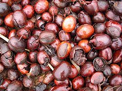
Trees of note include the shea tree (known as karité in the local Dioula language and the baobab. [1] Although the shea tree is indigenous to the semi-arid Sahel region of West Africa, Burkina Faso contains the largest number of them. [3] The shea tree is extremely important to the Burkinabe people and is termed as "women's gold" by the villagers, because the nuts of shea tree can be collected and then processed by crushing and grinding to yield shea butter, important in cuisine and in exports, for use in the manufacture of chocolate and cosmetics such as soap. [3] Shea nuts are the country's third most important export, after cotton and livestock; in 1997, an average tonne of unprocessed shea nuts sold domestically for CFA70,000 (US$980) and overseas for CFA1,00,000 (US$1400). [3] The most important centres of shea butter production are in Sissili Province and Ziro Province. [3] The bark of the tree is also used as an ingredient in traditional medicines and the shell of nut is said to be able to repel mosquitoes and is also said to protect existing trees. [3] The Bambara groundnut (Vigna subterranea) is also grown in abundance; Burkina Faso produced some 20,000 tonnes in 1989, after peanuts (160,000 tonnes) and cowpeas (74,000 tonnes). [17] Between 1982 and 1985, an attempt was made to improve the Bambara groundnut, an initiative which involved the participation of plant breeders in the Grain Legumes Programme. [17]

The country contains populations of Vitellaria paradoxa trees, which often have problems with parasites of the family Loranthaceae. [18] Four species of Tapinanthus ( Tapinanthus dodoneifolius , Tapinanthus globiferus , Tapinanthus ophiodes and Tapinanthus pentagonia ) are widespread all across Burkina Faso and Mali and are also subject to being affected by pests. [18] Other trees include Acacia , flamboyant tree, Delonix regia , and neem tree.

Conservation

Fauna conservation areas were first established in 1926, which included five 'parcs de refuge' that covered 536,700 ha. [19]

Global Environment Facility (GEF) in its report to the World Bank to promote conservation of natural habitat in Burkina Faso reported that the biodiversity species profile of Burkina Faso contains "655 wildlife species (mammals and birds); 330 aquatic species (includes 121 fish species), and 1054 plant species (751 grass, 304 tree and brush species)", based on meagre data. [8] It was also noted that the natural habitats were found now only in parks, reserves and gazetted forests as agricultural operations dominated the scene in 70% area of the country. The oryx, cheetah, and giraffe are reported to be totally extinct, probably includes Burkina redneck ostrich. The nearing extinction species were reported to be black and white colobus, dama gazelle, leopard and topi. This alarming situation of loss of biodiversity resulted in creation of national operational strategies not only for rural development in 2001 but also for reforms in the wildlife and protected area sector in 1995 (a Forestry Code was introduced defining the National Forestry Policy and establishing 12 Wildlife Conservation Units covering the entire country in followed in 1996) and Biodiversity Strategy and Action Plan in 2000 with the objective stated as to "ensure responsible management of biological diversity by the populations by 2025". [8]

In conservation and sustainable resources management efforts, the IBA Local Conservation Group with help from BirdLife Partners around the world have set up "site support groups" in Burkina Faso, which was initially begun in 1959 to count birds. This resulted in the training of local volunteers as ornithologists. In 2009, Vogelwacht Utrecht, a Dutch regional volunteer birding group, supported efforts conserve migratory birds. Cambridgeshire Bird Club in the UK has also pitched in with support. However, all these efforts are concentrated at Lake Oursi (included in the List of Ramsar wetlands of international importance) and are yet to permeate to a national scale. [20]

Related Research Articles

<span class="mw-page-title-main">Geography of Burkina Faso</span> Landlocked Sahel country that shares borders with six nations

Burkina Faso is a landlocked Sahel country that shares borders with six nations. It lies between the Sahara desert and the Gulf of Guinea, south of the loop of the Niger River, mostly between latitudes 9° and 15°N, and longitudes 6°W and 3°E. The land is green in the south, with forests and fruit trees, and semi-arid in the north. Most of central Burkina Faso lies on a savanna plateau, 198–305 metres (650–1,001 ft) above sea level, with fields, brush, and scattered trees. Burkina Faso's game preserves – the most important of which are Arly, Nazinga, and W National Park—contain lions, elephants, hippopotamus, monkeys, common warthogs, and antelopes. Previously the endangered painted hunting dog, Lycaon pictus occurred in Burkina Faso, but, although the last sightings were made in Arli National Park, the species is considered extirpated from Burkina Faso.

<span class="mw-page-title-main">Geography of Ivory Coast</span>

Ivory Coast is a sub-Saharan nation in southern West Africa located at 8 00°N, 5 00°W. The country is approximately square in shape. Its southern border is a 515 km (320 mi) coastline on the Gulf of Guinea on the north Atlantic Ocean. On the other three sides it borders five other African nations for a total of 3,458 km (2,149 mi): Liberia to the southwest for 778 km (483 mi), Guinea to the northwest for 816 km (507 mi), Mali to the north-northwest for 599 km (372 mi), Burkina Faso to the north-northeast for 545 km (339 mi), and Ghana to the east for 720 km (447 mi).

<span class="mw-page-title-main">Sahel</span> Ecoclimatic and biogeographic transition zone in Africa

The Sahel is a region in Africa. It is defined as the ecoclimatic and biogeographic realm of transition between the Sahara to the north and the Sudanian savanna to the south. Having a hot semi-arid climate, it stretches across the south-central latitudes of Northern Africa between the Atlantic Ocean and the Red Sea.

<span class="mw-page-title-main">W National Park</span> National park in West Africa

The W National Park or W Regional Park is a major national park in West Africa around a meander in the Niger River shaped like the letter W. The park includes areas of the three countries Niger, Benin and Burkina Faso, and is governed by the three governments. Until 2008, the implementation of a regional management was supported by the EU-funded project ECOPAS. The three national parks operate under the name W Transborder Park.. The section of W National Park lying in Benin, measuring over 8,000 km2 (3,100 sq mi), came under the full management of African Parks in June 2020. In Benin, W National Park is contiguous with Pendjari National Park which is also under the management of African Parks.

<span class="mw-page-title-main">Pendjari National Park</span> UNESCO World Heritage Site

The Pendjari National Park lies in north western Benin, adjoining the Arli National Park in Burkina Faso. Named for the Pendjari River, the national park is known for its wildlife and is home to some of the last populations of big game like the African forest elephant, lion, hippopotamus, African buffalo, and various antelopes in West Africa. The park is also famous for its richness in birds.

<span class="mw-page-title-main">Ethiopian Highlands</span> Mountain range in northern Ethiopia

The Ethiopian Highlands is a rugged mass of mountains in Ethiopia in Northeast Africa. It forms the largest continuous area of its elevation in the continent, with little of its surface falling below 1,500 m (4,900 ft), while the summits reach heights of up to 4,550 m (14,930 ft). It is sometimes called the Roof of Africa due to its height and large area. Most of the Ethiopian Highlands are part of central and northern Ethiopia, and its northernmost portion reaches into Eritrea.

<span class="mw-page-title-main">Sudanian savanna</span> African ecoregion

The Sudanian savanna is a broad belt of tropical savanna that runs east and west across the African continent, from the Atlantic Ocean in the west to the Ethiopian Highlands in the east. The Sahel, a belt of drier grasslands and acacia savannas, lies to the north, between the Sudanian savanna and the Sahara Desert. To the south the forest-savanna mosaic forms a transition zone between the Sudanian savanna and the Guineo-Congolian forests that lie nearer the equator.

<span class="mw-page-title-main">Wildlife of Chad</span>

The wildlife of Chad is composed of its flora and fauna. Bush elephants, West African lions, buffalo, hippopotamuses, Kordofan giraffes, antelopes, African leopards, cheetahs, hyenas, and many species of snakes are found there, although most large carnivore populations have been drastically reduced since the early 20th century. Elephant poaching, particularly in the south of the country in areas such as Zakouma National Park, is a severe problem.

<span class="mw-page-title-main">Wildlife of Ivory Coast</span> Flora and fauna of Ivory Coast in West Africa

The wildlife of Ivory Coast consists of the flora and fauna of this nation in West Africa. The country has a long Atlantic coastline on the Gulf of Guinea and a range of habitat types. Once covered in tropical rainforest, much of this habitat has been cleared, the remaining terrain being gallery forests and savanna with scattered groups of trees, resulting in a decrease in biodiversity. As of 2016, 252 species of mammal had been recorded in Ivory Coast, 666 species of bird, 153 species of reptile, 80 species of amphibian, 671 species of fish and 3660 species of vascular plant.

<span class="mw-page-title-main">Wildlife of Benin</span> Natural flora and fauna of Benin

Benin has varied resources of wildlife comprising flora and fauna, which are primarily protected in its two contiguous protected areas of the Pendjari National Park and W National Park. The former is known for many species of avifauna and the latter park is rich in mammals and predators. In addition, many other forest reserves are noted in the country but are not easily accessible, well protected or adequately surveyed for its wildlife resources. The protected area of Benin which is defined as a National Protected Area System is in northern Benin, mostly with a woody savanna ecosystem. It covers 10.3 percent of the nation and is part of the three-nation W-Arly-Pendjari Complex (WAP).

<span class="mw-page-title-main">Wildlife of the Gambia</span>

Wildlife of the Gambia is dictated by several habitat zones over its total land area of about 10,000 km2. It is bound in the south by the savanna and on the north by the Sudanian woodlands. The habitats host abundant indigenous plants and animals, in addition to migrant species and newly planted species. They vary widely and consist of the marine system, coastal zone, estuary with mangrove vegetation coupled with Banto Faros, river banks with brackish and fresh water zones, swamps covered with forests and many wetlands.

<span class="mw-page-title-main">Wildlife of Nigeria</span>

The wildlife of Nigeria consists of the flora and fauna of this country in West Africa. Nigeria has a wide variety of different habitats, ranging from mangrove swamps and tropical rainforest to savanna with scattered clumps of trees. About 290 species of mammal and 940 species of bird have been recorded in the country.

<span class="mw-page-title-main">Wildlife of Niger</span>

The wildlife of Niger is composed of its flora and fauna. The wildlife protected areas in the country total about 8.5 million hectares, which is 6.6 percent of the land area of the country, a figure which is expected to eventually reach the 11‑percent target fixed by the IUCN with the addition of more areas under the reserve category. Conservation of wildlife is ensured by laws and regulations enacted by the Government of Niger, which has enforced a permanent ban on hunting so that animals such as lions, hippos and giraffes are safe in the wild.

<span class="mw-page-title-main">Wildlife of Togo</span>

The wildlife of Togo is composed of the flora and fauna of Togo, a country in West Africa. Despite its small size the country has a diversity of habitats; there are only remnants of the once more extensive rain forests in the south, there is Sudanian Savanna in the north-western part of the country and larger areas of Guinean forest-savanna mosaic in the centre and northeast. The climate is tropical with distinct wet and dry seasons. There are estimated to be over 3000 species of vascular plant in the country, and 196 species of mammal and 676 species of bird have been recorded there.

The wildlife of Mali, composed of its flora and fauna, is widely varying from the Saharan desert zone to the Sahelian east–west zone, to Mali, a landlocked francophone country in North Africa; large swathes of Mali remain unpopulated but has three sub-equal vegetation zones; the country has Sahara Desert in the north, the Niger River Basin at its center and the Senegal River on the south.

Deux Balés National Park is a national park located in central eastern Burkina Faso. It is within Mouhoun Province just west of the Black Volta River and at an elevation of 235-310m.

Mont Sângbé National Park is a national park in Ivory Coast. The Encyclopædia Britannica lists it among the "principal national parks of the world". It acquired national park status in 1976.

<span class="mw-page-title-main">West Sudanian savanna</span> Tropical savanna ecoregion across Western Africa

The West Sudanian savanna is a tropical savanna ecoregion that extends across West Africa.

References

  1. 1 2 3 4 5 6 7 8 9 "Burkina Faso:Plants and animal life". Encyclopædia Britannica . Retrieved 24 April 2011.
  2. 1 2 3 Adjima Thiombiano, Marco Schmidt, Stefan Dressler, Amadé Ouédraogo, Karen Hahn, Georg Zizka. 2012. Catalogue des plantes vasculaires du Burkina Faso. Boissiera 65, Conservatoire et Jardin Botaniques de la ville de Genève. 391 S. ISBN   978-2-8277-0081-3
  3. 1 2 3 4 5 6 "Wild Shea Tree Benifitting[sic] Burkina Faso: Women Engaged in Shea Sector Gain From Trade In 'Shea Butter'". Gender and Trade: Commonwealth Secretariat. Archived from the original on 5 June 2011. Retrieved 24 April 2011.
  4. Cirelli, Maria Teresa; Food and Agriculture Organization of the United Nations. Development Law Service (2002). Legal trends in wildlife management. Food & Agriculture Org. p. 40. ISBN   978-92-5-104785-9 . Retrieved 24 April 2011.
  5. 1 2 3 4 5 6 7 "Burkina Faso" (PDF). BirdLife International. pp. 117–123. Archived from the original (PDF) on 15 October 2012.
  6. "Deux Balés National Park". UNEP-WCMC. Archived from the original on 5 November 2010.
  7. Onishi, Norimitsu (10 May 2001). "Baporo Forest; A Stately Elephant Moment, a Bit Like an Elegy". The New York Times . Retrieved 28 April 2011.
  8. 1 2 3 4 "Burkina Faso: Partnership for Natural Ecosystem Management Program (PAGEN)" (PDF). Global Environment Facility. 2 May 2002. pp. 5–7, 57.
  9. "W of the Niger National Park". parc-w.net. Archived from the original on 4 October 2011. Retrieved 28 April 2011.
  10. International Monetary Fund; Burkina Faso. Ministry of Economy and Development (2005). Burkina Faso: Poverty Reduction Strategy Paper. International Monetary Fund. pp. 48–. GGKEY:WNFW0FHLYBH.
  11. 1 2 Kormos, R. (2003). West African chimpanzees: status survey and conservation action plan. IUCN. p. 121. ISBN   978-2-8317-0733-4.
  12. Mills, M. G. L.; Mills, G.; Hofer, H. (1998). Hyaenas: status survey and conservation action plan. IUCN. p. 75. ISBN   978-2-8317-0442-5 . Retrieved 25 April 2011.
  13. International Union for Conservation of Nature and Natural Resources. Crocodile Specialist Group (1992). Crocodiles: an action plan for their conservation. IUCN. p. 16. ISBN   978-2-8317-0060-1.
  14. "Avibase – Bird Checklists of the World:Burkina Faso". Avibase-The world bird data base. Retrieved 24 April 2011.
  15. Marco Schmidt: Pflanzenvielfalt in Burkina Faso. Analyse, Modellierung und Dokumentation. 2006
  16. Sawadogo, Jean-Marie (October 1997). "Burkina Faso protects its fragile soils: Environmental sustainability is key to agricultural revival". Africa Recovery . United Nations. 11 (2): 20. Archived from the original on 8 November 2009. Retrieved 24 April 2011.
  17. 1 2 I Drabo; P Sérémé; C Dabire (1997). "Burkina Faso". In Heller, Joachim; Begemann, Frank; Mushonga, Joseph N. (eds.). Bambara groundnut Vigna subterranea (L.) Verdc: proceedings of the Workshop on Conservation and Improvement of Bambara Groundnut (Vigna subterranea (L.) Verdc.) : 14–16 November 1995, Harare, Zimbabwe. Bioversity International. p. 19. ISBN   978-92-9043-299-9.
  18. 1 2 Boffa, Jean-Marc (1999). Agroforestry parklands in Sub-Saharan Africa. Food & Agriculture Organization. p. 36. ISBN   978-92-5-104376-9.
  19. Afrotropical. IUCN. 1992. p. 36. ISBN   978-2-8317-0092-2.
  20. "Twelve years of site support in Burkina Faso". Birdlife International. 29 January 2010. Archived from the original on 30 November 2010. Retrieved 25 April 2010.