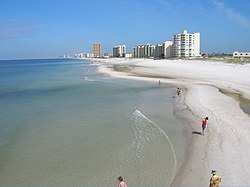
It is a popular vacation destination. Panama City Beach's slogan is "The World's Most Beautiful Beaches" due to the unique,[5] sugar-white sandy beaches of the Florida Panhandle. The city is also a popular spring break destination, due to its beach and proximity to most of the Southern United States.
Panama City Beach has dangerous rip currents.[6] Multiple people have drowned at Panama City Beach while struggling against rip currents.[6] Sea conditions are particularly dangerous during periods when lifeguards have put up double red flags, indicating active rip currents.[6] Drowning often occurs when people attempt to swim directly against a rip current.[7] By attempting to directly return to the beach, against the rip current, swimmers get tired-out in the process and drown.[7] Instead, swimmers caught in a rip current should relax, and swim parallel to the beach, until they are naturally carried out of the rip current.[7]
History
Panama City Beach was incorporated as a city in 1970 when a number of beachside communities merged, including the original Panama City Beach resort area founded by Gideon Thomas after the US 98 Hathaway Bridge across the west bay out of Panama City opened in 1929. Thomas purchased land along what became Thomas Dr in 1932 and opened for business in 1936. Also Long Beach Resort, created by J. E. Churchwell when he purchased land that was a former defunct beach resort owned by W.T. Sharpless (who was murdered after trying to collect tax from beachgoers in 1931) at the intersection of Thomas Dr & Front Beach Road in 1932 & opened for business in 1935. Other communities and resorts involved in the merger were Edgewater Gulf Beach, West Panama City Beach, Laguna Beach, Dutchville, Playville and Julia.[8][9][10]
Real estate boom
A construction boom in the early to mid-2000s changed the image of the area due to the older homes and motels being replaced with high-rise condominiums and more expansive homes. However, this is turning unobstructed, low-rise beach views and affordable waterfront property into rarities. At the peak of the real estate boom, many beachfront properties had quadrupled or more in value since 2000. In November 2006 CNN/Money named Panama City Beach the No. 1 real estate market in America for the next five years in.[11]
Beachfront property has sold for upwards of $60,000 per "front foot" (linear foot) at the top of the market. The downturn in the U.S. real estate market in 2007, combined with a surge of new condo construction, brought spiraling prices somewhat under control. With the real estate boom, Panama City Beach became a well known destination for spring break.[12]
Category 5Hurricane Michael made landfall near Mexico Beach in Bay County on October 10, 2018, becoming one of the strongest and most-destructive hurricanes in American history as it destroyed a large part of the county, including many structures in Mexico Beach and Panama City.[13][14] An EF-0 tornado did minor damage to the northwest part of Panama City Beach, Florida on February 15.
Geography
According to the United States Census Bureau, the town has a total area of 18.6 square miles (48.2km2), of which 18.4 square miles (47.6km2) is land and 0.23 square miles (0.6km2) – or 1.17% – is water.[15][16]
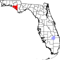
Panama City Beach is located towards the eastern half of the Florida Panhandle, along the Gulf of Mexico.[15][16] The main roads through the town are U.S. Route 98 and Florida State Road 30. US 98 runs from northwest to southeast just inland from the coast, leading east 10mi (16km) to Panama City and northwest 47mi (76km) to Destin. FL-30 runs along the coast from northwest to southeast as Front Beach Rd, leading east to Panama City and northwest 15mi (24km) to Rosemary Beach. There are approximately 9 miles (14km) of shoreline in Panama City Beach fronting the Gulf of Mexico.[15][16]
As of the 2020 United States census, there were 18,094 people, 5,538 households, and 3,440 families residing in the town.[20]
As of the 2010 United States census, there were 12,018 people, 5,149 households, and 3,166 families residing in the town.[21]
In 2010,[2] the population density was 653.2 personsper square mile (252.2 persons/km2). There were 17,141 housing units at an average density of 931.6 housesper square mile (359.7 houses/km2).[4]
In 2010, there were 5,149 households, out of which 21.1% had children under the age of 18 living with them, 42.9% were headed by married couples living together, 9.2% had a female householder with no husband present, and 43.4% were non-families. 31.3% of all households were made up of individuals. 9.5% were someone living alone who was 65 years of age or older. The average household size was 2.22. The average family size was 2.76.[4]
In 2010, 18.0% of the population were under the age of 18, 10.3% from 18 to 24, 27.2% from 25 to 44, 29.0% from 45 to 64, and 15.5% who were 65 years of age or older. The median age was 40.9 years. For every 100 females, there were 99.6 males. For every 100 females age 18 and over, there were 100.0 males.[4]
In the 2000 census, the median income for a household in the town was $41,198, and the median income for a family was $49,127. Males had a median income of $32,459 versus $22,358 for females. The per capita income for the town was $26,734. About 2.2% of families and 5.0% of the population were below the poverty line, including 3.9% of those under age 18 and 4.5% of those age 65 or over.
Government
The City of Panama City Beach has a council–manager government. The Mayor sits as a Council member-at-large and presides over City council meetings. If the Mayor cannot preside over a City Council meeting, then the Vice Mayor is the presiding officer of the meeting until the Mayor returns to his seat.
The City Manager is responsible for the administration and the day-to-day operation of all of the municipal services and city departments. The City Manager also maintains intergovernmental relationships with federal, state, county and other local governments.
The primary law enforcement agency in the town is the Panama City Beach Police Department. Part of the town is in unincorporated Bay County and is under the jurisdiction of the Bay County Sheriff's Office.
City council
Stuart Tettemer (Republican) – Mayor Term: 2024–2028
Paul Casto (Unknown) – Ward 1 Councilman Term: 2022–2026
The Northwest Florida Beaches International Airport (ECP) provides commercial flights into the area. The airport serves private aircraft, domestic passenger flights, and freight/cargo flights. It is the first international airport to be constructed after the September 11 terrorist attacks. Other modes of transportation include scooters, which can be rented by the day, as well as taxi and shuttle companies, which are permitted by the local police.
Panama City Beach also has public bus transportation known as Bayway available hourly Monday through Saturday. The Bayway runs throughout the county giving its tourists and locals the resource they need to get around Bay County.
State Road 79 is a north–south highway that starts in Panama City Beach and heads north to Interstate 10 and on to the Alabama state line.
State Road 30, formerly US 98 Alt, also named Front Beach Road, is an east–west highway that runs mostly along the beach front, beginning and ending at US 98.
State Road 392A, also named Hutichison Boulevard (formerly known as Middle Beach Road), is an east–west highway that runs slightly inland, generally parallel, and beginning and ending at State Road 30/Front Beach Road.
Sports
The town was home to the Panama City Beach Pirates, a fourth-division soccer team from 2007 to 2015.
Frank Brown Park – 100-acre complex with baseball, softball, soccer and t-ball fields, basketball and tennis courts, several playgrounds, shuffleboard courts, a youth fishing pond, three dog park enclosures, and a 20-acre festival site.[24]
Panama City Acquatics Center – located at Frank Brown Park, the center includes an outdoor Olympic-size pool and kids splash pool.[24]
Publix Sports Park – 160-acre sports complex with 13 fields for soccer, lacrosse, baseball, and more. Nine are synthetic turf fields.[25]
St. Andrews State Park – offers a variety of experiences included swimming, boating, camping, snorkeling, bicycling, and more.[26]
Gallery
Panama City Beach Panorama
The town lies on Florida's "Emerald Coast" of the Gulf of Mexico
Gulf Coast Jam – this 3-day outdoor concert event is held annually in May/June and showcases country music performers. The event in 2024 is sold out.[28]
This page is based on this Wikipedia article Text is available under the CC BY-SA 4.0 license; additional terms may apply. Images, videos and audio are available under their respective licenses.