Scouting in New Jersey has a long history, from the 1910s to the present day, serving thousands of youth in programs that suit the environment in which they live. The second Boy Scouts of America National Headquarters was in North Brunswick, although it was referred to in BSA publications as being in neighboring New Brunswick.

In Southern New Jersey and Philadelphia folklore, the Jersey Devil is a legendary creature said to inhabit the Pine Barrens of South Jersey. The creature is often described as a flying biped with hooves, but there are many variations. The common description is that of a kangaroo-like or wyvern-like creature with a goat- or horse-like head, leathery bat-like wings, horns, small arms with clawed hands, legs with cloven hooves, and a forked tail. It has been reported to move quickly and is often described as emitting a high-pitched "blood-curdling scream".

The New Jersey Pine Barrens, also known as the Pinelands or simply the Pines, is the largest remaining example of the Atlantic coastal pine barrens ecosystem, stretching across more than seven counties of New Jersey. Two other large, contiguous examples of this ecosystem remain: the Long Island Central Pine Barrens, and the Massachusetts Coastal Pine Barrens. The name pine barrens refers to the area's sandy, acidic, nutrient-poor soil. Although European settlers could not cultivate their familiar crops there, the unique ecology of the Pine Barrens supports a diverse spectrum of plant life, including orchids and carnivorous plants. The area is also notable for its populations of rare pygmy pitch pines and other plant species that depend on the frequent fires of the Pine Barrens to reproduce. The sand that composes much of the area's soil is referred to by the locals as sugar sand.

The Maurice River is a tributary of Delaware Bay in Salem County and Cumberland County, New Jersey in the United States. The river was named for Maurice, Prince of Orange.
South Mountain or South Mountains may refer to:

Pines Lake is an unincorporated community on a lake in Wayne, in Passaic County, New Jersey, United States. Pines Lake was started in the 1920s as a vacation community around a man-made lake approximately 1.5 miles (2.4 km) long and 0.5 miles (0.80 km) wide. Many of the original homes were modified log cabins. A large number of these log cabins, built of American chestnut in the 1930s, are still occupied as year-round homes. Gradually the neighborhood became approximately 500 high end to moderate suburban homes. It has a grammar school, Pines Lake School and its residents can send their high school aged children to Wayne Hills High School.

Fire Island Pines is a hamlet in the Town of Brookhaven, Suffolk County, New York, United States. It is located on Fire Island, a barrier island on the southern side of Long Island.

Grover Cleveland Park, the seventh-largest park in the Essex County, New Jersey, USA, county-park system, is a heavily wooded park covering 41.48 acres (167,900 m2) in the western section of Essex County along the Caldwell-Essex Fells border.
County Route 539, abbreviated CR 539, is a county highway in the U.S. state of New Jersey. The highway extends 54.32 miles (87.42 km) from Main Street in Tuckerton to CR 535 in Cranbury Township. Much of the two-lane route passes through isolated areas of the Pine Barrens and Joint Base McGuire–Dix–Lakehurst. In these stretches, the route has a speed limit of 55 miles per hour (89 km/h), one of the few two-lane roads in the state to carry a 55 mph limit. CR 539 passes through three boroughs: Tuckerton, Allentown, and Hightstown. Other than those boroughs, the route travels mainly through rural townships.

Parvin State Park, located in the southwestern part of New Jersey is a park whose history is as varied as its wildlife. Situated on the edge of the Pine Barrens, the park not only has pine forests, but also a swamp hardwood forest. The park is located near Pittsgrove Township in Salem County. The park is operated and maintained by the New Jersey Division of Parks and Forestry.

Bay Street is a New Jersey Transit station on Pine Street between Bloomfield and Glenridge Avenues in Montclair, New Jersey, along the Montclair-Boonton Line. The station is served by all trains on the line, including all ten weekend trains. The first station of six in Montclair, Bay Street is the southernmost, servicing the downtown district. The station was built originally in 1981 to replace the Lackawanna Terminal built near Grove Street in 1913 as a part of creating the Montclair Connection. Upon its opening on February 27, 1981, Bay Street was a lone platform with a single shelter. In 2002, as part of the Montclair Connection, Bay Street was completely rebuilt to standards for ADA accessibility, including two high-level platforms and a new elevator for a bridge crossing the tracks. The station also received honors in July 2010 for the development around the station and as a result was a part of getting Montclair designated a Transit Village, by the New Jersey Department of Transportation, under the Transit Village Initiative.

Westland Mansion was the home of Grover Cleveland, the 22nd and 24th President of the United States, from his retirement in 1897 until his death in 1908. The house is located in the historic district of Princeton, New Jersey, and is a National Historic Landmark also known as the Grover Cleveland Home.

Warren Grove is an unincorporated rural community that is a part of Stafford Township, Barnegat Township and Little Egg Harbor Township in Ocean County, New Jersey, United States. Its location in the heart of the Pine Barrens makes it one of the most secluded and remote corners of the state.

New Jersey is a state within the United States of America that lies on the north eastern edge of the North American continent. It shares a land border with the state of State of New York along the north, ratified by both states after the New York – New Jersey Line War. New Jersey is slightly larger than the country of Kuwait.

Concord is an unincorporated community in Sussex County, Delaware, United States. Concord is located along Delaware Route 20 east of Seaford.

The Hunter's Run and Slate Belt Railroad was a railway line from the Hunter's Run junction of the Gettysburg and Harrisburg Railway that ran southwestward along the south side of Mountain Creek to the Pine Grove Iron Works. The line serviced facilities for mining, for manufacturing, and for recreation. Portions of the railbed are a section of the Appalachian Trail as well as the majority of the Cumberland County Biker/Hiker Trail and the entire "Old Railroad Bed Road" that is the southeast border of Pine Grove Furnace State Park.

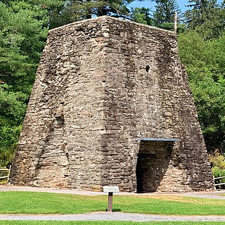
The Pine Grove Iron Works was a southcentral Pennsylvania smelting facility during the Industrial Revolution. The works is notable for remaining structures that are historical visitor attractions of Pine Grove Furnace State Park, including the furnace stack of the Pine Grove Furnace. The site was listed on the National Register of Historical Places on April 13, 1977 for its significance in architecture and industry. It includes seven contributing buildings, two structures, fourteen sites, and two objects.

Penn State Forest is a 3,366-acre (5.259 sq mi) state park in Burlington County, New Jersey, United States. The forest is protected as a section of the environmentally sensitive Pine Barrens. Various recreational resources are available to visitors including Oswego Lake and the Oswego River for swimming, boating, and fishing. The lake has a picnic area with a boat launch, swimming area, and primitive restrooms. Miles of unpaved roads composed of gravel, dirt, and sand traverse all areas of the forest. The roads are open for hiking, mountain biking, horseback riding, and cross-country skiing, as well as four-wheel driving. Hunting for deer, wild turkey, water fowl, and small game is permitted in season. A section of the Pine Barren Plains, a globally rare dwarf forest ecosystem that reaches a mature canopy height of about 4 ft (1.2 m), is located in the northeastern portion of the park. Penn State Forest is operated and maintained by the New Jersey Division of Parks and Forestry.


