
Illinois Institute of Technology is a private research university in Chicago, Illinois. Tracing its history to 1890, the present name was adopted upon the merger of the Armour Institute and Lewis Institute in 1940. The university has programs in architecture, business, communications, design, engineering, industrial technology, information technology, law, psychology, and science. It is classified among "R2: Doctoral Universities – High research activity".
Oak Park is a village in Cook County, Illinois, adjacent to Chicago. It is the 29th-most populous municipality in Illinois with a population of 54,583 as of the 2020 U.S. Census estimate. Oak Park was first settled in 1835 and later incorporated in 1902, when it separated from Cicero. Architect Frank Lloyd Wright and his wife settled in Oak Park in 1889, and his work heavily influenced local architecture and design, including the Frank Lloyd Wright Home and Studio. Over the years, rapid development was spurred by railroads and street cars connecting the village to jobs in nearby Chicago. In 1968, Oak Park passed the Open Housing Ordinance, which helped devise strategies to integrate the village rather than resegregate.

Riverside is a suburban village in Cook County, Illinois, United States. A significant portion of the village is in the Riverside Landscape Architecture District, designated a National Historic Landmark in 1970. The population of the village was 8,875 at the 2010 census. It is a suburb of Chicago, located roughly 9 miles (14 km) west of downtown Chicago and 2 miles (3 km) outside city limits.

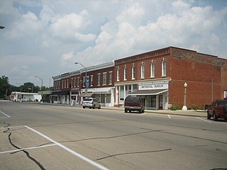
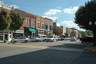
Orangeville is a village in Stephenson County, Illinois. The town's sign lists the population at 800 as of January 2021. The population in 2020 was 738. The population according to the 2010 census was 793, up from 751 in 2000. Using the 2020 population of 738 Orangeville is the 741st largest city in Illinois and the 11,650th largest city in the United States. Orangeville is currently declining at a rate of -0.94% annually and its population has decreased by -6.94% since the 2010 census. The area's earliest white settlers arrived in the year 1833, and the village was platted in 1851 by John Bower, who is considered the village founder. In 1867 Orangeville was incorporated as a village. The town's central business district contains several 19th century commercial buildings, many of which were built during the railroad boom of 1888–1914. By the time the Great Depression was ongoing, business in Orangeville had started to decline, with the last bank closing in 1932. In 1956 another bank started operating in the village and is still in town today. Some recent infrastructure jumps have restored some of the village's old decor.

The West End Historic District of Dallas, Texas, is a historic district that includes a 67.5-acre (27.3 ha) area in northwest downtown, generally north of Commerce, east of I-35E, west of Lamar and south of Woodall Rodgers Freeway. It is south of Victory Park, west of the Arts, City Center, and Main Street districts, and north of the Government and Reunion districts. A portion of the district is listed on the U.S. National Register of Historic Places as Westend Historic District. A smaller area is also a Dallas Landmark District. The far western part of the district belongs to the Dealey Plaza Historic District, a National Historic Landmark around structures and memorials associated with the Assassination of John F. Kennedy.

The Sycamore Historic District is a meandering area encompassing 99 acres (400,000 m2) of the land in and around the downtown of the DeKalb County, Illinois, county seat, Sycamore. The area includes historic buildings and a number of historical and Victorian homes. Some significant structures are among those located within the Historic District including the DeKalb County Courthouse and the Sycamore Public Library. The district has been listed on the National Register of Historic Places since May 2, 1978.

The Printing House Row District is a National Historic Landmark District encompassing four architecturally important buildings on the 300 through 500 blocks of South Dearborn, South Federal and South Plymouth streets in the Loop community area of Chicago, Illinois. It was listed on the National Register of Historic Places as South Dearborn Street – Printing House Row Historic District and listed as a National Historic Landmark as South Dearborn Street – Printing House Row North Historic District on January 7, 1976. The district was designated a Chicago Landmark on May 9, 1996. The district includes the Monadnock Building, the Manhattan Building, the Fisher Building, and the Old Colony Building. The district overlaps significantly with the Printers Row neighborhood, and is not the same as South Loop Printing House District.
The Main Street Historic District in Tampico, Illinois, United States is a historic district notable as home to the birthplace of Ronald Reagan. The district includes the late 19th century collection of buildings that comprise Tampico's central business district, among them are two apartments that the Reagan family occupied in the early 1900s. The buildings in the district went through several periods of rebuilding during the 1870s due to major fires and a tornado. The district boundaries encompass the 100 block of Main Street and exclude properties that do not date from the historic period.

The Galena Historic District is a historic district located in the city of Galena, Illinois, United States. The historic district encompasses 85 percent of the city of Galena and includes more than 800 properties. The downtown area consists of three successive tiers made up of Main, Bench and Prospect Streets. Within the boundaries of the district are such notable homes as the Ulysses S. Grant Home and the Elihu B. Washburne House. The Galena Historic District was added to the U.S. National Register of Historic Places in 1969.

Ste. Genevieve Historic District is a historic district encompassing much of the built environment of Ste. Genevieve, Missouri. The city was in the late 18th century the capital of Spanish Louisiana, and, at its original location a few miles south, capital of French Louisiana as well. A large area of the city, including fields along the Mississippi River, is a National Historic Landmark District designated in 1960, for its historically French architecture and land-use patterns, while a smaller area, encompassing the parts of the city historically important between about 1790 and 1950, was named separately to the National Register of Historic Places in 2002.

The North Easton Historic District is a historic district in Easton, Massachusetts encompassing a cohesive village area developed in the late 19th and early 20th centuries, primarily through the activities of the locally important Ames family. The district was added to the National Register of Historic Places in 1972. In 1987, a portion of the district was designated a National Historic Landmark District, known as the H. H. Richardson Historic District of North Easton, which includes several buildings designed for the Ameses by architect H. H. Richardson.

The South Main and Washington Streets Historic District — 68-139 Washington St. and 2-24 South Main St. is a historic district in South Norwalk, Connecticut. The 110-acre (45 ha) district encompasses 35 buildings and two other structures. Varied architectural styles from the late 19th and early 20th centuries include Romanesque Revival, Second Empire, and Italianate architecture. Half of the area first became part of the National Register of Historic Places in 1977. The district was increased in 1985 with the addition of nine buildings on 2.5 acres (1.0 ha) and again in 1999, with another 10 buildings on 3 acres (1.2 ha), roughly along North Main Street from Washington Street to Ann Street.

There are nine historic districts in Meridian, Mississippi. Each of these districts is listed on the National Register of Historic Places. One district, Meridian Downtown Historic District, is a combination of two older districts, Meridian Urban Center Historic District and Union Station Historic District. Many architectural styles are present in the districts, most from the late 19th century and early 20th century, including Queen Anne, Colonial Revival, Italianate, Art Deco, Late Victorian, and Bungalow.
Prairie Avenue is a north–south street on the South Side of Chicago, which historically extended from 16th Street in the Near South Side to the city's southern limits and beyond. The street has a rich history from its origins as a major trail for horseback riders and carriages. During the last three decades of the 19th century, a six-block section of the street served as the residence of many of Chicago's elite families and an additional four-block section was also known for grand homes. The upper six-block section includes part of the historic Prairie Avenue District, which was declared a Chicago Landmark and added to the National Register of Historic Places.

The Barre Downtown Historic District encompasses the historic commercial and civic heart of the city of Barre, Vermont. Extending along Main Street from City Park to Depot Square, this area was developed quite rapidly in the 1880s and 1890s, when the area experienced rapid growth due to the expansion of the nearby granite quarries. It was listed on the National Register of Historic Places in 1979.
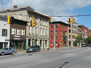
The Belvidere South State Street Historic District is a historic district on the north side of the Kishwaukee River in Belvidere, Illinois. It is primarily composed of commercial building representative of architectural trends from 1852 to 1962, the period following the connection of the city to the Galena and Chicago Union Railroad.
The St. Albans Historic District encompasses most of the historic commercial core of the city of St. Albans, Vermont. The district includes the historic town common, which acts as its focal center, and commercial and civic architecture dating from the early 19th to early 20th centuries. The district was listed on the National Register of Historic Places in 1980.

The St. Johnsbury Historic District encompasses much of the historic civic and commercial center of St. Johnsbury, Vermont. Representing a significant expansion of the Railroad Street Historic District and the St. Johnsbury Main Street Historic District, it captures the historical tension and competition between Main Street and Railroad Street for primacy as the town's most important civic and commercial areas. The district was listed on the National Register of Historic Places in 1980.
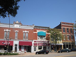
The Princeton South Main Street-Courthouse Square Historic District is a national historic district in Princeton, Illinois. Centered on South Main Street and the Bureau County Courthouse, the district is the older of the two downtown areas in Princeton, with the other being on North Main Street. Development in the area began with the settlement of Princeton in the 1830s and continued through the mid-twentieth century. The courthouse square was established when the county's first courthouse opened in 1845; the current Art Moderne courthouse was built there in 1937. South Main Street was considered the more upscale of Princeton's two downtowns, as it lacked the functional and agricultural businesses associated with the city's railroad station. The district's buildings reflect the popular architectural styles of the nineteenth and twentieth centuries; Italianate and Arts and Crafts designs are especially common, though Green Revival, Queen Anne, Neoclassical, Prairie School, and Moderne buildings are also present.

The South Main Street Historic District in Memphis, Tennessee, is located south of the city's central business district encompassing over 100 mostly commercial buildings spread across 11 blocks. The area was constructed between 1900 and 1930 in a wide range of early-twentieth-century architectural styles including Beaux Arts, Georgian Revival, Art Deco and Chicago Commercial. The district was added to the National Register of Historic Places in 1982 as an area of Memphis representing the impact of the railroad on the city during the a period of railroad-led prosperity that ended with the Great Depression. The district includes the Lorraine Motel, constructed in 1925, where Martin Luther King Jr. was assassinated in 1968. The South Main Arts District is a smaller area within the historic district. The district is also a City of Memphis local historic district or Historic Overlay District.


