Princeville, Illinois

Last updated

Princeville
Library2001.jpg
Lillie M. Evans Library, Princeville
Motto: 
The Village With A Vision
Peoria County Illinois Incorporated and Unincorporated areas Princeville Highlighted.svg
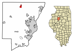
Location of Princeville in Peoria County, Illinois.
Illinois in United States (US48).svg
Location of Illinois in the United States
Coordinates: 40°55′54″N89°45′21″W / 40.93167°N 89.75583°W / 40.93167; -89.75583
CountryUnited States
StateIllinois
County Peoria
Area
[1]
  Total1.69 sq mi (4.39 km2)
  Land1.69 sq mi (4.39 km2)
  Water0.00 sq mi (0.00 km2)
Population
 (2020)
  Total1,636
  Density965.76/sq mi (372.81/km2)
Time zone UTC-6 (CST)
  Summer (DST) UTC-5 (CDT)
ZIP Code(s)
61559
Area code 309
FIPS code 17-61925
Wikimedia CommonsCategory:Princeville, Illinois
Website princeville.org

Princeville is a village in Peoria County, Illinois, United States. The population was 1,738 at the 2010 census, up from 1,621 in 2000. It is part of the Peoria, Illinois Metropolitan Statistical Area.

Contents

Geography

According to the 2010 census, Princeville has a total area of 1.66 square miles (4.30 km2), all land. [2] [3]

Demographics

Historical population
CensusPop.Note
1860 263
1870 42461.2%
1880 50920.0%
1890 64125.9%
1900 84832.3%
1910 98215.8%
1920 1,0355.4%
1930 994−4.0%
1940 9960.2%
1950 1,11311.7%
1960 1,28115.1%
1970 1,45513.6%
1980 1,71217.7%
1990 1,421−17.0%
2000 1,62114.1%
2010 1,7387.2%
2020 1,636−5.9%
U.S. Decennial Census [4]

As of the census [5] of 2000, there were 1,621 people, 659 households, and 452 families residing in the village. The population density was 1,239.4 inhabitants per square mile (478.5/km2). There were 748 housing units at an average density of 571.9 per square mile (220.8/km2). The racial makeup of the village was 97.59% White, 0.31% Native American, 0.12% Asian, 1.30% from other races, and 0.68% from two or more races. Hispanic or Latino of any race were 2.71% of the population.

There were 659 households, out of which 33.1% had children under the age of 18 living with them, 56.4% were married couples living together, 10.0% had a female householder with no husband present, and 31.3% were non-families. 28.2% of all households were made up of individuals, and 13.2% had someone living alone who was 65 years of age or older. The average household size was 2.46 and the average family size was 3.02.

In the village, the population was spread out, with 26.5% under the age of 18, 7.3% from 18 to 24, 27.5% from 25 to 44, 21.5% from 45 to 64, and 17.3% who were 65 years of age or older. The median age was 37 years. For every 100 females, there were 92.7 males. For every 100 females age 18 and over, there were 89.8 males.

The median income for a household in the village was $40,060, and the median income for a family was $49,118. Males had a median income of $31,957 versus $22,727 for females. The per capita income for the village was $19,137. About 6.7% of families and 6.7% of the population were below the poverty line, including 8.2% of those under age 18 and 3.3% of those age 65 or over.

Notable people

Transportation

SR 90 in Princeville runs East and West through Princeville. SR 91 shares with SR 90 until it reaches Santa Fe Ave in Princeville. Those highways are all two lane highways.

Schools

Princeville is District 326. They have 17 buses for students. It is a district with Princeville Junior/Senior High School, and Princeville Grade School. Princeville is a small community school district.

Related Research Articles

<span class="mw-page-title-main">Crescent City, Illinois</span> Village in Illinois, United States

Crescent City is a village in Iroquois and Crescent townships, Iroquois County, Illinois, United States. The population was 552 at the 2020 census.

<span class="mw-page-title-main">Washburn, Illinois</span> Village in Illinois, United States

Washburn is a village mostly in Woodford County, with a small northerly portion in Marshall County, Illinois, United States. The population was 1,032 at the 2020 census. It is part of the Peoria Metropolitan Statistical Area.

<span class="mw-page-title-main">Sherrard, Illinois</span> Village in Illinois, United States

Sherrard is a village in Mercer County, Illinois, United States. The population was 692 at the 2020 census.

<span class="mw-page-title-main">Raymond, Illinois</span> Village in Illinois, United States

Raymond is a village in Montgomery County, Illinois, United States. The population was 949 at the 2020 census.

<span class="mw-page-title-main">Bartonville, Illinois</span> Village in Illinois, United States

Bartonville is a village in Peoria County, Illinois, United States. The population was 6,471 at the 2010 census. Bartonville is a suburb of Peoria and is part of the Peoria, Illinois Metropolitan Statistical Area.

<span class="mw-page-title-main">Bellevue, Illinois</span> Village in Illinois, United States

Bellevue is a village in Peoria County, Illinois, United States. The population was 1,978 at the 2010 census. Bellevue is a suburb of Peoria and is part of the Peoria, Illinois Metropolitan Statistical Area.

<span class="mw-page-title-main">Brimfield, Illinois</span> Village in Illinois, United States

Brimfield is a village in Peoria County, Illinois, United States.

<span class="mw-page-title-main">Dunlap, Illinois</span> Village in Illinois, United States

Dunlap is a village in Peoria County, Illinois, United States. Its population was 1,386 people as of the 2010 census. Dunlap is part of the Peoria metropolitan area and growth in the city of Peoria is extending towards the village. There are only a handful of businesses in the village's 16 blocks.

<span class="mw-page-title-main">Glasford, Illinois</span> Village in Illinois, United States

Glasford is a village in Peoria County, Illinois, United States. The population was 866 at the 2020 census. Glasford is part of the Peoria, Illinois Metropolitan Statistical Area.

<span class="mw-page-title-main">Kingston Mines, Illinois</span> Village in Illinois, United States

Kingston Mines is a village in Peoria County, Illinois, United States. The population was 259 at the 2000 census. It is part of the Peoria, Illinois Metropolitan Statistical Area. Located on the Illinois River, it was a shipping port, loading coal from the nearby mines.

<span class="mw-page-title-main">Mapleton, Illinois</span> Village in Illinois, United States

Mapleton is a small village in Peoria County, Illinois, United States. The population was 227 at the 2000 census. Mapleton is part of the Peoria, Illinois Metropolitan Statistical Area. There are four different plants in Mapleton, all located along U.S. Route 24: an Evonik chemical plant, a Lonza Group plant, a Caterpillar Inc. foundry, and an Ingredion facility; together, the large industrial complex forms one of Mapleton's most significant employers and a good source of skilled employees and good jobs.

<span class="mw-page-title-main">Norwood, Illinois</span> Village in Illinois, United States

Norwood is a village in Peoria County, Illinois, United States. The population was 478 at the 2010 census. Norwood, just outside Peoria, is part of the Peoria, Illinois Metropolitan Statistical Area.

<span class="mw-page-title-main">Bradford, Illinois</span> Village in Illinois, United States

Bradford is a village in Stark County, Illinois, United States. The population was 768 at the 2010 census. Bradford is part of the Peoria, Illinois Metropolitan Statistical Area.

<span class="mw-page-title-main">Creve Coeur, Illinois</span> Village in Illinois, United States

Creve Coeur is a village in Groveland Township, Tazewell County, Illinois, United States. As of the 2020 census, the village population was 4,934. Creve Coeur is a suburb of Peoria and is part of the Peoria, Illinois Metropolitan Statistical Area.

<span class="mw-page-title-main">Deer Creek, Illinois</span> Village in Illinois, United States

Deer Creek is a village in Tazewell and Woodford counties in the U.S. state of Illinois. The population was 667 at the 2020 census. Deer Creek is part of the Peoria, Illinois Metropolitan Statistical Area.

<span class="mw-page-title-main">Hopedale, Illinois</span> Village in Illinois, United States

Hopedale is a village in Tazewell County, Illinois, United States. The population was 865 at the 2010 census. It is part of the Peoria, Illinois Metropolitan Statistical Area. The town is also home to a small number of restaurants, general stores, parks, and the Hopedale Medical Complex.

<span class="mw-page-title-main">Morton, Illinois</span> Village in Illinois, United States

Morton is a village in Tazewell County, Illinois, United States. The population was 17,117 at the 2020 census. Morton is a suburb of Peoria, located southeast of Peoria, and is part of the Peoria Metropolitan Statistical Area. The community holds a yearly Morton Pumpkin Festival for four days every September, and claims that "99 percent of the world's canned pumpkin is produced in Morton," earning it the designation "Pumpkin Capital of the World".

<span class="mw-page-title-main">North Pekin, Illinois</span> Village in Illinois, United States

North Pekin is a village in Tazewell County, Illinois, United States. The population was 1,573 at the 2010 census. North Pekin is a suburb of Peoria and is part of the Peoria, Illinois Metropolitan Statistical Area.

<span class="mw-page-title-main">Germantown Hills, Illinois</span> Village in Illinois, United States

Germantown Hills is a village in Woodford County, Illinois, approximately 8 miles (13 km) northeast of Peoria. Germantown Hills is the only incorporated community in Worth Township. As of the 2010 census, the village had a total population of 3,438. Largely an agricultural community until its incorporation in 1954, Germantown Hills is now a growing bedroom community in the Peoria Metropolitan Area.

<span class="mw-page-title-main">Metamora, Illinois</span> Village in Illinois, United States

Metamora is a village in Metamora Township, Woodford County, Illinois, United States. The population was 3,636 at the 2010 census. Metamora is a growing suburb of Peoria and is part of the Peoria, Illinois Metropolitan Statistical Area.

References

  1. "2020 U.S. Gazetteer Files". United States Census Bureau. Retrieved March 15, 2022.
  2. "G001 - Geographic Identifiers - 2010 Census Summary File 1". United States Census Bureau. Archived from the original on February 13, 2020. Retrieved December 25, 2015.
  3. "US Gazetteer files: 2010, 2000, and 1990". United States Census Bureau. February 12, 2011. Retrieved April 23, 2011.
  4. "Census of Population and Housing". Census.gov. Retrieved June 4, 2015.
  5. "U.S. Census website". United States Census Bureau . Retrieved January 31, 2008.