Pune Camp

Last updated

Camp
Pune Cantt
Cantonment
MGRd Pune Camp.jpg
MG Road in Pune Cantonment
PCBLogo.png
India Maharashtra location map.svg
Red pog.svg
Camp
Location in Maharashtra, India
Coordinates: 18°25′25″N73°54′32″E / 18.42361°N 73.90889°E / 18.42361; 73.90889 Coordinates: 18°25′25″N73°54′32″E / 18.42361°N 73.90889°E / 18.42361; 73.90889
CountryFlag of India.svg  India
State Maharashtra
Region Paschim Maharashtra
Division Pune
District Pune
Established1817
Taluka Haveli taluka
Government
  BodyPune Cantonment Board
  Cantonment Executive OfficerShri. Amit Kumar [1]
Area
  Total11.9 km2 (4.6 sq mi)
Elevation
577 m (1,893 ft)
Population
 (2005) [2]
  Total79,454
  Density6,700/km2 (17,000/sq mi)
Languages
  Official Marathi
Time zone UTC+5:30 (IST)
PIN
411 0xx
Telephone code(91)20
Vehicle registration MH 12, MH 14
Lok Sabha constituency Pune
Vidhan Sabha constituency Pune Cantonment
Civic agency Pune Cantonment Board
Climate Tropical Wet & Dry (Köppen)
Avg. annual temperature24 °C (75 °F)
Avg. summer temperature30 °C (86 °F)
Avg. winter temperature12 °C (54 °F)
Website www.punecantonmentboard.org

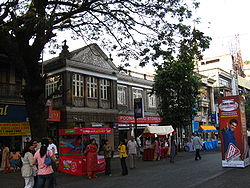
Pune Cantt, also known as Camp, is a military cantonment located in the city of Pune, India. It was established in 1817 for accommodating troops of the Indian Army. The cantonment houses many military establishments. It is also known for its shopping locations, MG Road and East Street. The headquarters of Indian Army's Southern Command is located in Pune Cantonment. The National War Memorial Southern Command which commemorates the sacrifice of soldiers of the Indian Armed Forces is also situated in the cantonment.

Contents

History

The British Indian Army already had a small encampment west of the Mula River in Khadki. As more troops were required to be accommodated, a larger area was occupied to the west of the Mutha River, leading to the establishment of the Pune Cantonment in 1817 [3] for accommodating troops of the British Indian Army. The villages of Mali, Munjeri, Wanowrie and Ghorpuri (Ghorpadi) were selected for this purpose. [4] Initially, a garrison for 4,620 troops was planned for the cantonment. This included two European regiments, a mountain battery, a native cavalry and three native regiments. [3] A central belt of 130 acres (0.53 km2) was designated for training and drills. The firing ranges were located at Golibar Maidan. [3] Soon a large number of civilians began settling in the area. This was encouraged since civilians provided services to troops garrisoned in the cantonment.

A statue of Sam Manekshaw in Pune Cantonment Sam Manekshaw's statue in Pune Cantonment.jpg
A statue of Sam Manekshaw in Pune Cantonment
The National War Memorial Southern Command in Pune Cantonment National War Memorial, Pune.JPG
The National War Memorial Southern Command in Pune Cantonment

The limit of the cantonment were extended in 1822. In 1963, Ghorpuri Village (Ghorpadi) and Fatima Nagar were merged into cantonment area. The limit of the cantonment was again extended in the same year when Mundhwa village was included in the cantonment.

Government and politics

Pune Cantonment is a part of the Pune Lok Sabha constituency. Pune Cantonment is a separate constituency of the Maharashtra Legislative Assembly (Vidhan Sabha). The currently elected Member of Legislative Assembly from Pune Cantonment constituency is Sunil Kamble. [5]

Civic administration

The Pune Cantonment Board is responsible for the civic administration of the cantonment. Pune Cantonment is not a part of Pune Municipal Corporation, instead, the Chairman, Cantonment Board is the head of the civic administration within the Cantonment Board area. The Lashkar Police Station is responsible for maintaining law and order in Pune Cantonment. [6] The cantonment comes under Zone II of the Pune Police.

Transport

Pune Cantonment is connected by public transport buses operated by the Pune Mahanagar Parivahan Mahamandal Limited. [7] Autorickshaws are easily available in the cantonment. The NH-65 which connects Pune to Machilipatnam via Solapur and Hyderabad passes through the cantonment. The nearest rail link to the cantonment is the Pune Railway Station. The nearest airport is the Pune International Airport.

Utility services

The Pune Municipal Corporation supplies water to the residents of Pune Cantonment. [4] The Pune Cantonment Board has also set up public water posts for usage by economically backward sections. Electricity is distributed by the Maharashtra State Electricity Distribution Company Limited.

Education

The Pune Cantonment Board runs one ITI college, three high schools and six primary schools in the cantonment area. [8] In addition to these, there are many other private schools and colleges in Pune Cantonment. The Armed Forces Medical College, a prominent landmark, is also located here. Azam Campus is one of the biggest college campus in cantonment area for students, with more than eight colleges like dental, business, hotel management, pharmacy, senior college, junior college for girls and 5 school.

Health

The Pune Cantonment Board runs the Cantonment General Hospital, [9] a 100 bedded hospital on the Solapur Road. It also runs 3 dispensaries in the Cantonment. A military hospital is also located in the cantonment. Additionally, Ruby Hall Clinic, Jehangir Hospital (both privately operated) and the Sassoon Hospital (state operated) are located in the vicinity of the cantonment.

See also

Related Research Articles

Pune Metropolis in Maharashtra, India

Pune is the seventh most populous city in India and the second-largest city in the state of Maharashtra, with an estimated population of 7.4 million as of 2020. It has been ranked "the most liveable city in India" several times. Along with the municipal corporation of PCMC, PMC and the three cantonment towns of Camp, Khadki, and Dehu Road, Pune forms the urban core of the eponymous Pune Metropolitan Region (PMR).

Ahmednagar City in Maharashtra, India

Ahmednagar (or sometimes just called Nagar) is a city in Ahmednagar district in the state of Maharashtra, India, about 120 km northeast of Pune and 114 km from Aurangabad. Ahmednagar takes its name from Ahmad Nizam Shah I, who founded the town in 1494 on the site of a battlefield where he won a battle against superior Bahamani forces. It was close to the site of the village of Bhingar. With the breakup of the Bahmani Sultanate, Ahmad established a new sultanate in Ahmednagar, also known as Nizam Shahi dynasty.

Mhow Cantonment Town in Madhya Pradesh, India

Mhow, officially Dr. Ambedkar Nagar, is a cantonment in the Indore district in Madhya Pradesh state of India. It is located 23 kilometres (14 mi) south-west of Indore city, towards Mumbai on the old Mumbai-Agra Road. The town was renamed as Dr. Ambedkar Nagar in 2003, by the Government of Madhya Pradesh.

Osmanabad district District of Maharashtra in India

Osmanabad District is an administrative district in the Marathwada region in the Indian state of Maharashtra. The district headquarter is located at Osmanabad. The District of Osmanabad derives its name from the last ruler of Hyderabad, the 7th Nizam, Mir Osman Ali Khan, of which the region was a part till 1947. This region was earlier part of The Hyderabad State until Independence.This primarily rural district occupies an area of 7,569 km2 (2,922 sq mi) of which 241.4 km2 (93.2 sq mi) is urban and has a population of 1,657,576 of which 16.96% were urban.

Pune district District of Maharashtra in India

Pune district is the second most populous district in the Indian state of Maharashtra. The district's population was 9,429,408 in the 2011 census, making it the fourth most populous district amongst India's 640 districts. This district has an urban population of 58.08 percent of its total. It is one of the most industrialized districts in India. In recent decades it has also become a hub for information technology.

Satara district District of Maharashtra in India

Satara district is a district of Maharashtra state in western India with an area of 10,480 km2 (4,050 sq mi) and a population of 3,003,741 of which 14.17% were urban. Satara is the capital of the district and other major towns include Medha, Wai, Karad, Koregaon, Dahiwadi, Koynanagar, Rahimatpur, Phaltan, Mahabaleshwar, Vaduj and Panchgani. This district comes under Pune Administrative Division along with Pune, Sangli, Solapur and Kolhapur. The district of Pune bounds it to the north, Raigad bounds it to the north-west, Solapur the east, Sangli to the south, and Ratnagiri to the west.

Khadki is a cantonment in the city of Pune, India. It has now flourished as a quasi-metropolis & centered in the northern region of the city.

Atpadi is an administrative town of the Atpadi Taluka of Sangli District in the Indian state of Maharashtra. Atpadi is located north-east of Sangli District and shares borders with the adjacent Solapur and Satara Districts. The town has a taluka administrative office, a courthouse, a police station, a government-run primary hospital, various schools and colleges and a theater. Atpadi's economy is based on the cultivation and sale of agricultural products, with pomegranates and cotton constituting the core of the industry. The town is also home to the Manganga Sahakari Sugar factory, a Pomegranate auction center and various small scale industries in fields such as manufacturing, processing, servicing and repairs.

Pune Municipal Corporation Local governing body of Pune

The Pune Municipal Corporation is the civic body that governs the inner limits of Pune, India. It is in charge of the civic needs and infrastructure of the metropolis, which is spread over an area of 484.61 sq. km. and has 3.4 million residents. Established on 15 February 1950, the executive power of the PMC is vested in the Municipal Commissioner, an Indian Administrative Service (IAS) officer appointed by the Government of Maharashtra. The position is held by Vikram Kumar, IAS.The general body of the PMC consists of 162 directly elected councilors, popularly known as "corporators", headed by a mayor. Murlidhar Mohol (BJP) was elected as the mayor and Sunita Wadekar as the deputy mayor by the newly elected in April 2021. The land for Pune Municipal Corporation was donated by Late Hon. Shri. Bhausaheb Shirole (Patil) who was second Mayor of Pune city and later became an MLC.

College of Military Engineering, Pune

College of Military Engineering (CME) is a technical and tactical engineering training institution of the Indian Army Corps of Engineers of the Indian Army. Training of Combat Engineers, Military Engineering Service, Border Roads Engineering Services (BRES) and Survey done here.

Pune Metropolitan Region Metropolitan region in Maharashtra, India

Pune Metropolitan Region (PMR) is the metropolitan region around the city of Pune. According to practical purposes, PMR comprises two Municipal Corporations of PMC, PCMC and three Cantonment Boards, spread over an area of 7,256.46 km2. The population of the region as per 2011 census was 7,541,946.

Kothrud Vidhan Sabha constituency is one of the 288 Maharashtra Vidhan Sabha (Assembly) constituencies of Maharashtra state in Western India. It is one of the twenty one constituencies of located in the Pune district and one of eight in Pune City.

Pune Cantonment Vidhan Sabha constituency is one of the twenty one constituencies of Maharashtra Vidhan Sabha located in the Pune district and one of eight in Pune City.

Pune railway division is one of the five railway divisions of Central Railway (India) Zone of Indian Railways located at Pune of Maharashtra state in western India. The other railway divisions are Mumbai CSMT, Nagpur, Solapur and Bhusawal. There are 71 railway stations in Pune railway division. station will now be a part of pune Railway division. 24 stations of daund-Ankai section will be merged with pune Railway division. Currently Daund-Ankai section is under solapur railway division. Merging with pune division will incarese the chances of starting demu services between Ahmednagar and pune railway station.

Vishrantwadi Suburban in Pune, Maharashtra, India

Vishrantwadi is a suburb of Pune City in the State of Maharashtra, India. Vishrantwadi is a bustling commercial and residential neighborhood to the north of the city and includes the areas of Mohanwadi, Pratik Nagar, Kasturbawadi, Phule Nagar, Mental Corner, Police Lines, Shanti Nagar, Dhanori, Tingre Nagar, Kalas, Mhaskewasti and Dighi.

St Josephs Boys High School, Pune School in India

St. Joseph Boys’ High School is a day school located in Khadki of Pune district, in the Indian state of Maharashtra. The school is an English Medium School established and managed by the Poona Diocesan Education Society. It is recognized by the Government of Maharashtra and consists of ten standards beyond Pre-Primary classes. It primarily prepares pupils for the Secondary School Certificate (S.S.C) Examination.

Ghorpuri (Ghorpadi) is a village in Kavathe-Mahankal Pune district in the Indian state of Maharashtra.

Shikrapur is a panchayat village in the state of Maharashtra, India. It is the largest village in the Shirur Taluka of Pune District in Maharashtra.

Parvati Vidhan Sabha constituency is one of the 288 Vidhan Sabha constituencies of Maharashtra state, western India. This constituency is located in Pune district. It is part of Pune.

Sunil Dnyandev Kamble is an Indian politician. He was elected to the Maharashtra Legislative Assembly from Pune Cantonment in the 2019 Maharashtra Legislative Assembly election as a member of Bharatiya Janata Party. He has previously served as Corporator in the Pune Municipal Corporation since 1992 - incumbent. He is known for his social work and direct approach. He was also elected as Standing Committee Chairperson of PMC in March 2019. He is the younger brother of 2 times BJP Minister Dilip Kamble. Coming from an extremely poor background, he emerged as a mass leader at a very young age. He began his social life as a young activist in ABVP. He played a pivotal role from the BJP side in campaigning and contacting on booth level in elections to the Balurghat Assembly constituency in West Bengal 2021 elections. Shri. Kamble currently is also a member of the legislative committee on Schedule Castes in the Maharashtra Legislature.

References

  1. "Welcome to Cantonment Board Pune" . Retrieved 20 December 2018.
  2. "Cities in India" . Retrieved 16 January 2010.
  3. 1 2 3 "History of the Southern Command" . Retrieved 4 December 2010.
  4. 1 2 "Pune Cantonment Administration Report" . Retrieved 28 November 2009.
  5. "Dilip Kamble(Bharatiya Janata Party(BJP)):Constituency- PUNE CANTONMENT (SC)(PUNE) - Affidavit Information of Candidate".
  6. "Pune Police Stations" . Retrieved 15 January 2010.
  7. "PMPML". Archived from the original on 5 December 2009. Retrieved 19 December 2009.
  8. "PCB Admin Report" . Retrieved 28 November 2009.
  9. "Pune Cantonment Board" . Retrieved 25 November 2009.