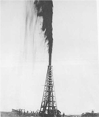
Spindletop is an oil field located in the southern portion of Beaumont, Texas, in the United States. The Spindletop dome was derived from the Louann Salt evaporite layer of the Jurassic geologic period. On January 10, 1901, a well at Spindletop struck oil. The Spindletop gusher blew for 9 days at a rate estimated at 100,000 barrels (16,000 m3) of oil per day. Gulf Oil and Texaco, now part of Chevron Corporation, were formed to develop production at Spindletop. The Spindletop discovery led the United States into the oil age. Prior to Spindletop, oil was primarily used for lighting and as a lubricant. Because of the quantity of oil discovered, burning petroleum as a fuel for mass consumption suddenly became economically feasible.
Garber is a city in Garfield County, Oklahoma, United States. The population was 822 at the 2010 census. The city is named after Martin Garber, father of Milton C. Garber, former U.S. congressman, Enid mayor, newspaper editor, and judge. The land was previously part of the Cherokee Outlet, until the U.S. government declared it open to non-Indian settlement in 1893.
Burning Springs is an unincorporated community in Wirt County, West Virginia, United States. It takes its name from the natural gas which bubbled up through the spring and would burn when lit.

Pithole, or Pithole City, is a ghost town in Cornplanter Township, Venango County, Pennsylvania, United States, about 6 miles (9.7 km) from Oil Creek State Park and the Drake Well Museum, the site of the first commercial oil well in the United States. Pithole's sudden growth and equally rapid decline, as well as its status as a "proving ground" of sorts for the burgeoning petroleum industry, made it one of the most famous of oil boomtowns.
Prudhoe Bay Oil Field is a large oil field on Alaska's North Slope. It is the largest oil field in North America, covering 213,543 acres (86,418 ha) and originally contained approximately 25 billion barrels (4.0×10⁹ m3) of oil. The amount of recoverable oil in the field is more than double that of the next largest field in the United States by acreage (the East Texas Oil Field), while the largest by reserves is the Permian Basin (North America). The field was operated by BP; partners were ExxonMobil and ConocoPhillips until August 2019; when BP sold all its Alaska assets to Hilcorp.

Well No. 4, Pico Canyon Oilfield, located about seven miles (11 km) west of Newhall, California, in the Santa Susana Mountains, was the first commercially successful oil well in the Western United States and is considered the birthplace of California's oil industry. Drilled in 1876, it turned nearby Newhall into a boomtown and also spawned a smaller boomtown called Mentryville adjacent to the drilling site. Well No. 4 continued in operation for 114 years until it was capped in 1990. The site was designated a National Historic Landmark in 1966, and the Mentryville ghost town is now open to the public as a historic park.
The Kuparuk River Oil Field, or Kuparuk, located in North Slope Borough, Alaska, United States, is the second largest oil field in North America by area. It started production in 1982, peaking in 1992. As of 2019, it produced approximately 71,021 barrels per day of oil for ConocoPhillips and has been estimated to have 2 billion barrels of recoverable oil reserves. It is named for the Kuparuk River.

The Oklahoma City Oil Field is one of the world's giant petroleum fields and is located in Oklahoma City, Oklahoma in the United States of America. The field was opened just south of the city limits on December 4, 1928, and first entered Oklahoma City limits on May 27, 1930.

The H.H. Champlin House is a two-and-one half-story sandstone building designed in the Tudor Revival style. The house, completed in 1939, is located at 612 S. Tyler in Enid, Oklahoma. It is located within the Kisner Heights addition to the city of Enid, developed from farmland formerly owned by R.H. Kisner. Architects Roy Shaw and Norris Wheeler designed the house. The D.C. Bass Company constructed the main house with walls of Briar Hill sandstone and Vermont slate roofing and terrace. A variety of windows were custom made for the house by Kawneer Company of Niles, Michigan. Jacoby Art Glass Company of St. Louis, Missouri created art glass insets for the Tudor arch windows, featuring scenes from Oklahoma history. The property also includes a carport and greenhouse. The property is currently owned by Enid businessman and attorney James Sears Bryant.

The First Oil Well in Western Canada, also known as Lineham Discovery Well No. 1, is a defunct oil well and national historic site of Canada. Which commemorates the September 21, 1902 oil strike in what is now Waterton Lakes National Park, Alberta. The oil well originally drilled in 1902, was the first productive oil well in the Western Canadian provinces.
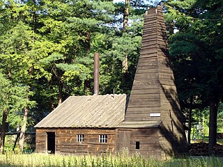
The Drake Well is a 69.5-foot-deep (21.2 m) oil well in Cherrytree Township, Venango County in the U.S. state of Pennsylvania, the success of which sparked the first oil boom in the United States. The well is the centerpiece of the Drake Well Museum located 3 miles (5 km) south of Titusville.

The story of oil production in California began in the late 19th century. In 1903, California became the leading oil-producing state in the US, and traded the number one position back-and forth with Oklahoma through the year 1930. As of 2022, California produced 3% of the crude oil of the nation, behind Texas, New Mexico, North Dakota, Alaska, Colorado, and Oklahoma. In the past century, California's oil industry grew to become the state's number one GDP export and one of the most profitable industries in the region. The history of oil in the state of California, however, dates back much earlier than the 19th century. For thousands of years prior to European settlement in America, Native Americans in the California territory excavated oil seeps. By the mid-19th century, American geologists discovered the vast oil reserves in California and began mass drilling in the Western Territory. While California's production of excavated oil increased significantly during the early 20th century, the accelerated drilling resulted in an overproduction of the commodity, and the federal government unsuccessfully made several attempts to regulate the oil market.
The Wheeler No. 1 Oil Well was the first well drilled in the Drumright-Cushing Oil Field of northeast Oklahoma, near Drumright. The success of the well, drilled in 1912 by Thomas Baker Slick, Sr., led to the development of the Cushing field and gave impetus to the early development of Oklahoma oilfields. The Drumright-Cushing field would go on to produce 310,000 barrels of oil a day at its peak in May 1917. The well made Slick's name as "King of the Wildcatters".

The Jackson Barnett No. 11 Oil Well was the most productive oil well in the Cushing Oil Field of northeastern Oklahoma, USA, to the south of Drumright. The well was drilled in 1916 in the Shamrock Dome section of the Cushing field by the Gypsy Oil Company, striking oil on February 17. The well was on the land of Jackson Barnett, a Creek landowner who subsequently became known as the "world's richest Indian".

The Cushing Oil Field, also known as the Cushing-Drumright Oil Field, is an oil field in northeastern Oklahoma, part of the Mid-Continent oil province. The 10-mile (16 km) by 3-mile (4.8 km) field includes southeastern Payne County, northwestern Creek County, and northeastern Lincoln County. Named for its primary supply center at Cushing, Oklahoma, the field was developed from 1912.
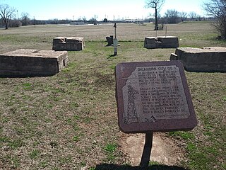
The Oklahoma City Discovery Well was the first successful oil well to be drilled in Oklahoma City, Oklahoma. The December 4, 1928 discovery opened the Oklahoma City Oil Field to extensive exploitation, creating an oil boom that sustained the area through the Great Depression. Because much of the oil was under the existing city, the Oklahoma City field pioneered the use of directional drilling to allow lateral displacement of well bores to reach deposits under developed areas.

Nellie Johnstone No. 1 was the first commercially productive oil well in Oklahoma. Completed on April 15, 1897, the well was drilled in the Bartlesville Sand near Bartlesville, opening an era of oil exploration and development in Oklahoma. It was abandoned as a well in 1964. The site was donated to the city of Bartlesville and is now a park, listed on the National Register of Historic Places, featuring a restored drilling rig.

The Cat Creek Oil Field is located near the community of Cat Creek in Petroleum and Garfield counties in the U.S. state of Montana. The geological terminology used by Bowen, the geologist, to define the geological structure of Cat Creek in 1914 was Cat Creek Anticline. Peak of production recorded in 1922, with 11 wells drilling was 3 million barrels of oil.
The Big Muddy oil field is an oil field in Converse County, Wyoming, between Casper and Glenrock.
John Robert Suman was a geologist, petroleum engineer, and business executive.


