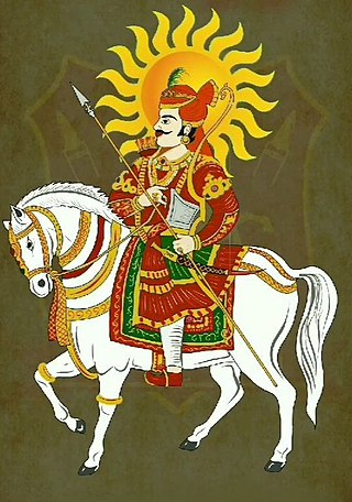
Veer Tejaji also known as Tejaji Maharaj, or simply Tejaji, was a great warrior, social reformer, cow protector and folk-deity in Rajasthan. In rural parts of northern Rajasthan, he is revered as a deity and is considered to be one of Lord Shiva's eleven primary incarnations. He is mainly worshipped in the states of Rajasthan, Madhya Pradesh, Haryana, Uttar Pradesh, and Gujarat. He is commonly known as the God of Snakes in Rajasthan, because it protect against snake bites or also worshipped as Dhauliya Veer.
Bayana is a historical town and the headquarters of Bayana tehsil in Bharatpur district of Rajasthan in India. Hindaun City is nearest city of Bayana - 33 km. Bayana is also known as the city of 'Vansasur'. It was the site of famous Important Battle of Bayana in 1527 between Rajput ruler Rana Sanga ruler of Mewar and Mughal emperor Babur.
Shri Ramachandra Kripalu, or "Shri Ram Stuti," is a Stuti verse from his work called Vinaya Patrika, written by Goswami Tulsidas. It was written in the sixteenth century in a mix of Sanskrit and Awadhi languages. The prayer/ode glorifies Shri Rāma and his characteristics to the best.
Thakur Balwant Singh Bakhasar was the dacoit of Bakhasar in Barmer district. The areas of his operation and influence were bordering areas of Barmer district, Sanchore in Rajasthan.
Gabhana is a tehsil, block, town and a Nagar panchayat in Aligarh district, 23 km from the district headquarters in the state of Uttar Pradesh, India.
Baje Bhagat was an Indian litterateur, poet, ragni writer, saang artist and Haryanvi cultural show artist. He was born in Sisana, Rohtak District, Punjab(Now Sonipat District, Haryana).
Munak and adjacent Kheri Munak is a village and development block in Assandh sub-district of Karnal district, Haryana, India. Munak canal, which diverts Western Yamuna Canal's water to New Delhi, originates here at Munak regulator.
Chitrasen Sahu, also known as "Half Human Robo," is an Indian mountaineer and inclusion and disability rights activist. He is the first double amputee from India to scale Mount Elbrus, Mount Kilimanjaro (Tanzania) and Mount Kosciuszko (Australia). He is also a national wheelchair basketball player.
Suryamal Mishran Shikhar Award is a literary honour granted by the Rajasthani Bhasha Sahitya and Sanskriti Akademi for special contribution to Rajasthani literature. It was established in the memory of the 19th century poet-historian Suryamal Misran.
"Chirja" is a devotional song in Rajasthani and Gujarati literature as a prayer to the female form of divine, Shakti. Chirja is a new poetic form in Shakti-Kavya in Rajasthani literature. Chirjas are primarily sung by women especially during Jagrans during the worship of goddess. The word Chirja is derived from the Sanskrit term Charya.
Thakur Zorawar Singh Barhath was an Indian revolutionary and independence activist. He is known for the assassination attempt on the Viceroy of India, Lord Hardinge, by throwing a bomb at him during a procession in New Delhi.

Jang Bahadur Singh is an Indian Bhojpuri folk singer and wrestler, who was popular during the 1940s to 1970s in the Bihar, Jharkhand & Bengal Region. He is an ardent follower of Mahatma Gandhi and his principles. He was born in Kausad village in the Siwan district of Bihar on 10 December 1920. He is a singer of 'Vyas Style', a genre of Bhojpuri folk singing. He was a celebrated wrestler in Bihar and Bengal Region. He was given the title of Sher-e-Bihar when he defeated a heavy weight wrestler from Bengal side. He used to inspire the youth to fight for freedom by singing patriotic songs, for which he was also imprisoned by the British. Nowadays, he resides in his paternal village living his remaining years of life in peace.
Shubham Rathi is an Indian social activist, promoting issues raised by Farmers, Students and labourers facing injustice in India. He is the state president of Uttar Pradesh student union in Uttar Pradesh and youth president of Jat Mahasabha in Uttar Pradesh. He is an alumnus of Hindu College, Delhi.
Chetavani ra Chungatya is a patriotic Dingal poem composed by Thakur Kesari Singh Barhath in 1903 and addressed to Maharana of Mewar, Fateh Singh, exhorting him to uphold the traditions of his lineage and to not attend the Delhi Durbar. The couplets had the desired effect on the Maharana who decided not to attend the durbar despite being present in Delhi. The work remains one of the great literary works produced during the freedom struggle. It consists of 13 stanzas or sortha (saurashtra-duha).

Raja Devi Bakhsh Singh was a British-era King from Gonda, Uttar Pradesh. He was born in 19th century AD. He featured in the Indian Rebellion of 1857 and is represented as symbol of religious harmony in India.
Nitin Dubey is an Indian singer, composer, actor, and lyricist. Born in Raigarh, Chhattisgarh. Dubey is known for his work as a composer, vocalist, music director, and playback singer in Chhattisgarh cinema and as a performer at various national level music festivals and bhajan programs.
Neelkamal Singh Kushwaha is an Indian singer. He is a well established singer in the Bhojpuri music industry. In December 2022, his song Judai is said to have gained more viewership, leaving behind the Lal Ghagra of Pawan Singh for a long period of time after release, which led to his inclusion among the notable Bhojpuri singers of the industry. A resident of Buxar, Bihar, Singh started his career in 2003. He was one of the participant in the music reality show Sur Sangram, where he was eliminated after reaching the top four. According to media reports, his networth is somewhere around 140 million.
Atul Kumar Rai is an Indian Hindi novelist and screenwriter. He is the author of Chandpur ki Chanda, which was awarded the 2023 Yuva Puraskar for Hindi language works by the Sahitya Akademi. He is also a dialogue writer of the 2022 film Sherdil: The Pilibhit Saga.
Om Prakash Singh is an Indian politician who has been serving as a member of the Uttar Pradesh Legislative Council representing Mathura-Etah-Mainpuri local Authority Constituencies since 12 April 2022.He represented the Bharatiya Janata Party.
