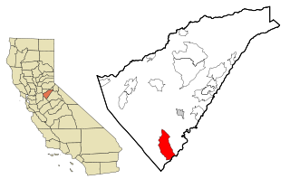
Copperopolis is an unincorporated town and census-designated place (CDP) in Calaveras County, California, United States. The population was 3,671 at the 2010 census, up from 2,363 at the 2000 census. The town is located along State Route 4 and is registered as California Historical Landmark #296.

Kennecott, also known as Kennicott and Kennecott Mines, is an abandoned mining camp in the Copper River Census Area in the U.S. state of Alaska that was the center of activity for several copper mines. It is located beside the Kennicott Glacier, northeast of Valdez, inside Wrangell-St. Elias National Park and Preserve. The camp and mines are now a National Historic Landmark District administered by the National Park Service.

State Route 49 is a north–south state highway in the U.S. state of California that passes through many historic mining communities of the 1849 California gold rush and it is known as the Golden Chain Highway. The highway's creation was lobbied by the Mother Lode Highway Association, a group of locals and historians seeking a single highway connect many relevant locations along the Gold Rush to honor the 49ers. One of the bridges along SR 49 is named for the leader of the association, Archie Stevenot.

The Quincy Mine is an extensive set of copper mines located near Hancock, Michigan. The mine was owned by the Quincy Mining Company and operated between 1846 and 1945, although some activities continued through the 1970s. The Quincy Mine was known as "Old Reliable," as the Quincy Mine Company paid a dividend to investors every year from 1868 through 1920. The Quincy Mining Company Historic District is a United States National Historic Landmark District; other Quincy Mine properties nearby, including the Quincy Mining Company Stamp Mills, the Quincy Dredge Number Two, and the Quincy Smelter are also historically significant.
Keweenaw National Historical Park is a unit of the U.S. National Park Service. Established in 1992, the park celebrates the life and history of the Keweenaw Peninsula in the Upper Peninsula of the U.S. state of Michigan. As of 2009, it is a partly privatized park made up of two primary units, the Calumet Unit and the Quincy Unit, and 21 cooperating "Heritage Sites" located on federal, state, and privately owned land in and around the Keweenaw Peninsula. The National Park Service owns approximately 1,700 acres (690 ha) in the Calumet and Quincy Units. Units are located in Baraga, Houghton, Keweenaw, and Ontonagon counties.
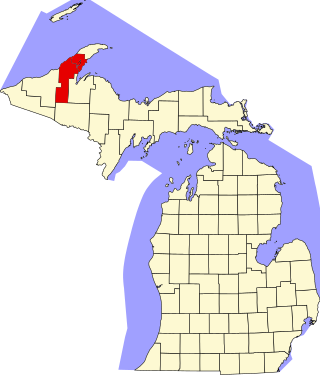
This is a list of the National Register of Historic Places listings in Houghton County, Michigan.

The Bremner Historic Mining District is a historic district in Wrangell-St. Elias National Park and Preserve in Alaska. It is named after John Bremner, who in 1884-1885 was the first non-native person to live in the area and who prospected for gold along the Bremner River. Located just to the north of the Bremner River, it was the scene of an important placer gold discovery in 1902, and played a key role in the history of the Copper River Basin. Only a few miners struck it rich, but the resulting demand for materials and supplies helped establish regional transportation networks, encouraged supporting industries, and hastened the exploration and settlement of the entire region. While small-scale placer mining continued for over forty years, lode development was largely confined to the period between 1934 and 1941, the district's most significant era.

The Calumet Historic District is a National Historic Landmark District that encompasses most of the village of Calumet, Michigan. The district was designated in 1989 for the community's importance in the history of the region's copper mining industry.

The J. Vivian Jr. and Company Building is a commercial building located at 342 Hecla Street in Laurium, Michigan. Constructed in the Italian Renaissance Revival and Italianate architectural styles, it was listed on the National Register of Historic Places in 2003.

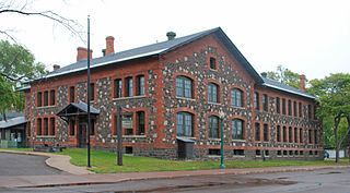
The Quincy Mine No. 2 Shaft Hoist House is an industrial building located north of Hancock, Michigan along US Highway 41 within the Quincy Mining Company Historic District. The Hoist House contains the largest steam hoisting engine in the world, which sits on the largest reinforced concrete engine foundation ever poured. The shaft hoist house was designated a Michigan State Historic Site in 1969 and listed on the National Register of Historic Places in 1970.

The Provo Downtown Historic District is a 25-acre (10 ha) historic area located in Provo, Utah, United States. It is listed on the National Register of Historic Places.

Copperopolis Congregational Church is a historic church building at 411 Main Street in Copperopolis, California. The church was built in 1866 and designed in the Gothic Revival style; it is the only Gothic Revival building remaining in Copperopolis and one of two in Calaveras County. The brick church features a Gothic arch entrance and windows, a gable roof, and a bell tower. The church held Congregational services until it was leased to the Presbyterian Church; it became a Congregational church again in 1874 and remained so until 1895. In 1903, the Independent Order of Odd Fellows bought the church and converted it to a lodge hall. The Odd Fellows owned the church until 1939, when it became a community center.

The Copperopolis Armory is a Civil War armory located at 695 Main St. in Copperopolis, California. The brick Greek Revival building was constructed in 1864 to house the Union Guard of Copperopolis, the town's regiment of the Union Army. Copperopolis largely owed its existence to the war; the town grew due to a boom in local copper mining in 1860, which stemmed from the Union Army's need for copper ammunition. The armory served a variety of purposes for the Union Guard; at the building, new soldiers were enlisted, training was conducted, and arms and supplies were stored. Military balls, victory celebrations, and the local funeral ceremonies for Abraham Lincoln also took place in the armory. The armory also held an 1837 bronze cannon, which was used for ceremonial purposes and arms training; the cannon remains in the building and is one of the few American bronze cannons from the era in California. After the war, the Independent Order of Odd Fellows bought the building, which they converted to a social hall. In 1940, the armory became a community center.

The Honigsberger Store is a historic building located at 665 Main St. in Copperopolis, California. Businessman L. Honigsberger built the store in 1865, replacing the original store he built in 1861. The brick building was designed in the Neoclassical style. The store served Copperopolis during its first copper boom in the 1860s; however, an 1867 fire and declining copper production caused Copperopolis to lose most of its population and severely diminished the store's business. In 1905, the Honigsberger family sold the store to the Union Copper Mining Company, which became the Calaveras Copper Mining Company four years later. The company used the store as a warehouse during another copper boom in Copperopolis from 1909 to 1929. The store is one of only four extant buildings from Copperopolis' first copper boom in the 1860s.
Copperopolis was a mining community situated in Meagher County, Montana, United States.

Bandshell Park, also known as City Park and Music Pavilion, is located in Ames, Iowa, United States. It is a nationally recognized historic district that was listed on the National Register of Historic Places in 1999. At the time of its nomination it consisted of six resources, which included one contributing building, one contributing site, two contributing structures, one contributing object, and one non-contributing object. The park, located to the east of the central business district, was gift to the city in 1884 from the C&NW Land Company. The full city block was the first park established in Ames.

The Bisbee Historic District is located in Bisbee, Arizona, and has all the essential features of a prosperous, early twentieth century mining town.


