
Geelong is a port city located on Corio Bay and the Barwon River, in the state of Victoria, Australia. Geelong is 75 kilometres (47 mi) south-west of the state capital, Melbourne. It is the second largest Victorian city, with an estimated urban population of 268,277 as of June 2018. Geelong runs from the plains of Lara in the north to the rolling hills of Waurn Ponds to the south, with Corio Bay to the east and the Barrabool Hills to the west. Geelong is the administrative centre for the City of Greater Geelong municipality, which covers urban, rural and coastal areas surrounding the city, including the Bellarine Peninsula.

Port Phillip , is a bay in southern Victoria, Australia. It is nearly surrounded by the city of Melbourne and its suburbs. Geographically, the bay covers 1,930 square kilometres and the shore stretches roughly 264 km (164 mi). Although it is extremely shallow for its size, most of the bay is navigable. The deepest portion is only 24 metres (79 ft), and half the region is shallower than 8 m (26 ft). The volume of the water in the port is around 25 cubic kilometres (6.0 cu mi).

Corio Bay is one of numerous bays in the southwest corner of Australia's Port Phillip, and is the bay on which abuts the City of Geelong. The nearby suburb of Corio takes its name from Corio Bay.

Avalon is a locality situated north east of Geelong, Victoria. Its local government area is the City of Greater Geelong and its Ward is Windermere. It is located on the northern shore of Corio Bay to the southwest of the state's capital city of Melbourne.

Mornington is a suburb of Melbourne on the Mornington Peninsula, Victoria, Australia, located 57 km (35 mi) south of Melbourne's central business district. It is in the local government area of the Shire of Mornington Peninsula.
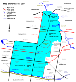
Doncaster East is a suburb of Melbourne, Victoria, Australia, 22 km north-east of Melbourne's Central Business District in the local government area of the City of Manningham. At the 2016 Census, Doncaster East had a population of 28,360.

The Division of Corio is an Australian electoral division in the state of Victoria. The division was proclaimed in 1900, and was one of the original 65 divisions to be contested at the first federal election. Named for Corio Bay, it has always been based on the city of Geelong, although in the past it stretched as far east as the outer western suburbs of Melbourne.
Corio is a residential and industrial area, which forms one of the largest suburbs of Geelong, Victoria in Australia. It is located approximately 9 km north of the Geelong central business district. The area was formerly known as Cowie's Creek after James Cowie, an early land owner who was active in the local and state government.
Lovely Banks is a northern suburb of Geelong, Victoria, Australia. Once an agricultural and rural area, the suburb is quickly developing into a residential area adjoining the Geelong suburbs of Bell Park, Corio and Norlane. At the 2016 Census Lovely Banks had a population of 2,301.

Little River is a town in Victoria, Australia, that is located about 49 kilometres (30 mi) south-west of the Melbourne central business district, located within the Cities of Greater Geelong and Wyndham local government areas. Little River recorded a population of 1,322 at the 2016 Census.
Lara is a small town in Victoria, 18 km north-east of the Geelong CBD, inland from the Princes Freeway to Melbourne.

North Shore is an industrial and residential suburb of Geelong, Victoria, Australia. The suburb overlooks Corio Bay. A small residential area is east of the North Shore railway station with a few neighbourhood shops.

Norlane is a northern suburb of Geelong, in Victoria, Australia. Norlane is bordered in the south by Cowies Creek, in the north by Cox Road, in the west by Thompson Road and in the east by Station Street. It is about 7 km from the Geelong central business district and approximately 70 km from the state capital, Melbourne. It is about one kilometre from the shore of Corio Bay. At the 2016 Census, Norlane had a population of 8,306.
Wandana Heights is a residential suburb of Geelong, Victoria, Australia. Suburban development of the suburb commenced in the 1980s which due to the current high property prices in Australia, and the fluctuation of prices in previous years housing development has been sporadic with periods where there has been no new constructions, punctuated with occasional spurts. Another factor affecting the growth of the area is the monetary value for plots, which is significantly higher than the neighbouring suburb of Highton due to the very expansive views of the surrounding district.

Geelong North is a suburb of Geelong in the Australian state of Victoria. The suburb was bypassed by traffic from Melbourne coming from the Princes Freeway by the creation of the Geelong Ring Road, which was complete in 2009. At the 2016 census, Geelong North had a population of 2,966. It is often referred to as North Geelong

Corio railway station is located on the Port Fairy line in Victoria, Australia, and serves the northern Geelong suburb of Corio, although the station is situated about a kilometre from the nearest residential developments in the area.

Tourism in Melbourne is a significant industry in the state of Victoria, Australia. The country's second most-populous city, Melbourne was visited by 2.7 million international overnight visitors and 9.3 million domestic overnight visitors during the year ending December 2017.

The City of Geelong was a local government area about 75 kilometres (47 mi) southwest of Melbourne, the state capital of Victoria, Australia. The city covered an area of 13.4 square kilometres (5.2 sq mi), and existed from 1849 until 1993.

Port Phillip, sometimes referred to as Port Phillip Bay, is a large bay in southern Victoria, Australia, 1,930 km² in area, with a coastline length of 264 km (164 mi). The bay is extremely shallow for its size, but mostly navigable. The deepest portion is only 24 m, and half the region is shallower than 8 m. Its volume is around 25 km³. The city of Melbourne is located at its northern end, near the mouth of the Yarra River.

Port Phillip is a bay in Victoria, Australia. It has many beaches, most of which are flat, shallow and long, with very small breaks making swimming quite safe. This attracts many tourists, mostly families, to the beaches of Port Phillip during the summer months and school holidays. Water sports such as body boarding and surfing are easy or simple, except in extreme weather conditions.

