Robinson, Kansas

Last updated

Robinson, Kansas
Aerial view of Robinson, Kansas 9-2-2013.JPG
Aerial view of Robinson (2013)
Brown County Kansas Incorporated and Unincorporated areas Robinson Highlighted.svg
Location within Brown County and Kansas
Map of Brown Co, Ks, USA.png
Coordinates: 39°48′56″N95°24′42″W / 39.81556°N 95.41167°W / 39.81556; -95.41167 [1]
Country United States
State Kansas
County Brown
Founded1871
Incorporated 1879
Named for Charles Robinson
Area
[2]
  Total0.24 sq mi (0.62 km2)
  Land0.24 sq mi (0.62 km2)
  Water0.00 sq mi (0.00 km2)
Elevation
[1]
951 ft (290 m)
Population
 (2020) [3]
  Total183
  Density760/sq mi (300/km2)
Time zone UTC-6 (CST)
  Summer (DST) UTC-5 (CDT)
ZIP code
66532
Area code 785
FIPS code 20-60325
GNIS ID 2396391 [1]
Website City website

Robinson is a city in Brown County, Kansas, United States. [1] As of the 2020 census, the population of the city was 183. [3]

Contents

History

Robinson had its start in the year 1871 by the building of the railroad through that territory. [4] [5] It was named to honor the first governor of the State of Kansas, Charles Robinson. [6] It had formerly been known locally as Lickskillet derived from the practice of an old trapper who allegedly put his dirty dishes out for his dog to lick clean. [7]

Geography

Robinson is located along the Wolf River. [8]

According to the United States Census Bureau, the city has a total area of 0.24 square miles (0.62 km2), all of it land. [9]

Demographics

Historical population
CensusPop.Note
1880 210
1900 493
1910 492−0.2%
1920 5001.6%
1930 457−8.6%
1940 413−9.6%
1950 381−7.7%
1960 317−16.8%
1970 278−12.3%
1980 32416.5%
1990 268−17.3%
2000 216−19.4%
2010 2348.3%
2020 183−21.8%
U.S. Decennial Census

2010 census

As of the census [10] of 2010, there were 234 people, 92 households, and 64 families residing in the city. The population density was 975.0 inhabitants per square mile (376.4/km2). There were 109 housing units at an average density of 454.2 per square mile (175.4/km2). The racial makeup of the city was 92.7% White, 0.4% from other races, and 6.8% from two or more races. Hispanic or Latino of any race were 1.3% of the population.

There were 92 households, of which 37.0% had children under the age of 18 living with them, 56.5% were married couples living together, 8.7% had a female householder with no husband present, 4.3% had a male householder with no wife present, and 30.4% were non-families. 23.9% of all households were made up of individuals, and 14.1% had someone living alone who was 65 years of age or older. The average household size was 2.54 and the average family size was 2.97.

The median age in the city was 42.5 years. 26.1% of residents were under the age of 18; 6.4% were between the ages of 18 and 24; 20.1% were from 25 to 44; 31.7% were from 45 to 64; and 15.8% were 65 years of age or older. The gender makeup of the city was 50.4% male and 49.6% female.

2000 census

As of the census [11] of 2000, there were 216 people, 94 households, and 62 families residing in the city. The population density was 887.0 inhabitants per square mile (342.5/km2). There were 111 housing units at an average density of 455.8 per square mile (176.0/km2). The racial makeup of the city was 93.98% White, 0.46% Native American, 0.46% Asian, 1.85% from other races, and 3.24% from two or more races. Hispanic or Latino of any race were 1.85% of the population.

There were 94 households, out of which 30.9% had children under the age of 18 living with them, 55.3% were married couples living together, 7.4% had a female householder with no husband present, and 33.0% were non-families. 29.8% of all households were made up of individuals, and 20.2% had someone living alone who was 65 years of age or older. The average household size was 2.30 and the average family size was 2.81.

In the city, the population was spread out, with 24.1% under the age of 18, 6.0% from 18 to 24, 21.8% from 25 to 44, 26.4% from 45 to 64, and 21.8% who were 65 years of age or older. The median age was 44 years. For every 100 females, there were 116.0 males. For every 100 females age 18 and over, there were 97.6 males.

The median income for a household in the city was $20,938, and the median income for a family was $24,375. Males had a median income of $30,208 versus $16,364 for females. The per capita income for the city was $13,203. About 13.8% of families and 22.3% of the population were below the poverty line, including 39.1% of those under the age of eighteen and 22.2% of those 65 or over.

Education

Robinson is a part of USD 415 Hiawatha Schools. The Hiawatha High School mascot is Hiawatha Red Hawks. [12]

Robinson High School was closed through school unification. The Robinson High School mascot was Cardinals. [13]

Notable people

Related Research Articles

<span class="mw-page-title-main">Brown County, Kansas</span> County in Kansas, United States

Brown County is a county located in the northeast portion of the U.S. state of Kansas. Its county seat and most populous city is Hiawatha. As of the 2020 census, the county population was 9,508. The county was named after Albert G. Brown, a U.S. Senator from Mississippi and Kansas statehood advocate. The Kickapoo Indian Reservation of Kansas, the majority of the Sac and Fox Reservation, and the majority of the Iowa Reservation of Kansas and Nebraska are located within the county.

<span class="mw-page-title-main">Everest, Kansas</span> City in Brown County, Kansas

Everest is a city in Brown County, Kansas, United States. As of the 2020 census, the population of the city was 265.

<span class="mw-page-title-main">Fairview, Kansas</span> City in Brown County, Kansas

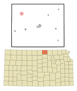
Fairview is a city in Brown County, Kansas, United States. As of the 2020 census, the population of the city was 240.

<span class="mw-page-title-main">Hamlin, Kansas</span> City in Brown County, Kansas

Hamlin is a city in Brown County, Kansas, United States. As of the 2020 census, the population of the city was 25.

<span class="mw-page-title-main">Hiawatha, Kansas</span> City in Brown County, Kansas

Hiawatha is the largest city and county seat of Brown County, Kansas, United States. As of the 2020 census, the population of the city was 3,280.

<span class="mw-page-title-main">Reserve, Kansas</span> City in Brown County, Kansas

Reserve is a city in Brown County, Kansas, United States. As of the 2020 census, the population of the city was 67. It is located approximately 1.5 miles south of the Nebraska-Kansas border.

<span class="mw-page-title-main">Gridley, Kansas</span> City in Coffey County, Kansas

Gridley is a city in Coffey County, Kansas, United States. As of the 2020 census, the population of the city was 313.

<span class="mw-page-title-main">Howard, Kansas</span> City in Elk County, Kansas

Howard is a city in and the county seat of Elk County, Kansas, United States. As of the 2020 census, the population of the city was 570.

<span class="mw-page-title-main">Richmond, Kansas</span> City in Franklin County, Kansas

Richmond is a city in Franklin County, Kansas, United States. As of the 2020 census, the population of the city was 459.

<span class="mw-page-title-main">Grinnell, Kansas</span> City in Gove County, Kansas

Grinnell is a city in Gove County, Kansas, United States. As of the 2020 census, the population of the city was 260.

<span class="mw-page-title-main">Formoso, Kansas</span> City in Jewell County, Kansas

Formoso is a city in Jewell County, Kansas, United States. As of the 2020 census, the population of the city was 94.

<span class="mw-page-title-main">Webber, Kansas</span> City in Jewell County, Kansas

Webber is a city in Jewell County, Kansas, United States. As of the 2020 census, the population of the city was 30.

<span class="mw-page-title-main">Winona, Kansas</span> City in Logan County, Kansas

Winona is a city in Logan County, Kansas, United States. As of the 2020 census, the population of the city was 193.

<span class="mw-page-title-main">Agra, Kansas</span> City in Phillips County, Kansas

Agra is a city in Phillips County, Kansas, United States. As of the 2020 census, the population of the city was 208.

<span class="mw-page-title-main">Belleville, Kansas</span> City in Republic County, Kansas

Belleville is a city in and the county seat of Republic County, Kansas, United States. As of the 2020 census, the population of the city was 2,007.

<span class="mw-page-title-main">Narka, Kansas</span> City in Republic County, Kansas

Narka is a city in Republic County, Kansas, United States. As of the 2020 census, the population of the city was 81.

<span class="mw-page-title-main">Republic, Kansas</span> City in Republic County, Kansas, United States

Republic is a city in Republic County, Kansas, United States. As of the 2020 census, the population of the city was 82.

<span class="mw-page-title-main">Bison, Kansas</span> City in Rush County, Kansas

Bison is a city in Rush County, Kansas, United States. As of the 2020 census, the population of the city was 179.

<span class="mw-page-title-main">Haddam, Kansas</span> City in Washington County, Kansas

Haddam is a city in Washington County, Kansas, United States. It is named after Haddam, Connecticut. As of the 2020 census, the population of the city was 110.

<span class="mw-page-title-main">Clayton, Kansas</span> City in Decatur and Norton Counties of Kansas

Clayton is a city in Decatur and Norton counties in the U.S. state of Kansas. As of the 2020 census, the population of the city was 44.

References

  1. 1 2 3 4 U.S. Geological Survey Geographic Names Information System: Robinson, Kansas
  2. "2019 U.S. Gazetteer Files". United States Census Bureau. Retrieved July 24, 2020.
  3. 1 2 "Profile of Robinson, Kansas in 2020". United States Census Bureau. Archived from the original on July 10, 2022. Retrieved July 10, 2022.
  4. Kansas State Historical Society (1916). Biennial Report of the Board of Directors of the Kansas State Historical Society. Kansas State Printing Plant. pp.  150.
  5. Blackmar, Frank Wilson (1912). Kansas: A Cyclopedia of State History, Volume 2. Standard Publishing Company. pp.  589.
  6. Capace, Nancy (June 1, 2000). Encyclopedia of Kansas. North American Book Dist LLC. p. 259. ISBN   978-0-403-09312-0.
  7. Kansas Place-Names, John Rydjord, University of Oklahoma Press, 1972, p. 327 ISBN   0-8061-0994-7
  8. DeLorme (2003), Kansas Atlas & Gazetteer, p. 26, Yarmouth, Maine: DeLorme. ISBN   0-89933-342-7.
  9. "US Gazetteer files 2010". United States Census Bureau. Archived from the original on January 25, 2012. Retrieved July 6, 2012.
  10. "U.S. Census website". United States Census Bureau . Retrieved July 6, 2012.
  11. "U.S. Census website". United States Census Bureau . Retrieved January 31, 2008.
  12. "Hiawatha Schools USD 415". USD 415. Retrieved January 5, 2017.
  13. "Robinson High School - Cardinal Yearbook". E-YEARBOOK.COM. Retrieved January 8, 2017.