Rock Falls, Iowa

Last updated
Rock Falls, Iowa
Cerro Gordo County Iowa Incorporated and Unincorporated areas Rock Falls Highlighted.svg
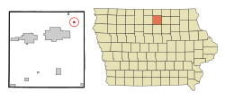
Location of Rock Falls, Iowa
Coordinates: 43°12′22″N93°5′10″W / 43.20611°N 93.08611°W / 43.20611; -93.08611 Coordinates: 43°12′22″N93°5′10″W / 43.20611°N 93.08611°W / 43.20611; -93.08611
Country Flag of the United States.svg  United States
State Flag of Iowa.svg  Iowa
County Cerro Gordo
Area
[1]
  Total0.21 sq mi (0.54 km2)
  Land0.21 sq mi (0.54 km2)
  Water0.00 sq mi (0.00 km2)
Elevation
1,102 ft (336 m)
Population
 (2020)
  Total150
  Density724.64/sq mi (279.85/km2)
Time zone UTC-6 (Central (CST))
  Summer (DST) UTC-5 (CDT)
ZIP code
50467
Area code 641
FIPS code 19-68025
GNIS feature ID0460739

Rock Falls is a city in Cerro Gordo County, Iowa, United States, along the Shell Rock River. The population was 150 at the time of the 2020 census. [2] It is part of the Mason City Micropolitan Statistical Area.

Contents

Geography

Rock Falls is located at 43°12′22″N93°5′10″W / 43.20611°N 93.08611°W / 43.20611; -93.08611 (43.206223, -93.086145). [3]

According to the United States Census Bureau, the city has a total area of 0.21 square miles (0.54 km2), all land. [4]

Demographics

Historical populations
YearPop.±%
1870 221    
1880 221+0.0%
1890 122−44.8%
1900 124+1.6%
1910 87−29.8%
1920 85−2.3%
1930 109+28.2%
1940 153+40.4%
1950 139−9.2%
1960 156+12.2%
1970 150−3.8%
1980 196+30.7%
1990 155−20.9%
2000 170+9.7%
2010 155−8.8%
2020 150−3.2%
Source: "U.S. Census website". United States Census Bureau . Retrieved 2020-03-29. and Iowa Data Center
Source:
U.S. Decennial Census [5] [2]

2010 census

As of the census [6] of 2010, there were 155 people, 68 households, and 50 families residing in the city. The population density was 738.1 inhabitants per square mile (285.0/km2). There were 74 housing units at an average density of 352.4 per square mile (136.1/km2). The racial makeup of the city was 98.7% White, 0.6% Asian, and 0.6% from two or more races.

There were 68 households, of which 22.1% had children under the age of 18 living with them, 66.2% were married couples living together, 4.4% had a female householder with no husband present, 2.9% had a male householder with no wife present, and 26.5% were non-families. 19.1% of all households were made up of individuals, and 10.3% had someone living alone who was 65 years of age or older. The average household size was 2.28 and the average family size was 2.64.

The median age in the city was 49.5 years. 14.8% of residents were under the age of 18; 4.7% were between the ages of 18 and 24; 24.5% were from 25 to 44; 29.1% were from 45 to 64; and 27.1% were 65 years of age or older. The gender makeup of the city was 51.0% male and 49.0% female.

2000 census

As of the census of 2000, there were 170 people, 68 households, and 55 families residing in the city. The population density was 806.7 inhabitants per square mile (311.5/km2). There were 69 housing units at an average density of 327.4 per square mile (126.4/km2). The racial makeup of the city was 100.00% White. Hispanic or Latino of any race were 0.59% of the population.

There were 68 households, out of which 32.4% had children under the age of 18 living with them, 69.1% were married couples living together, 5.9% had a female householder with no husband present, and 19.1% were non-families. 17.6% of all households were made up of individuals, and 8.8% had someone living alone who was 65 years of age or older. The average household size was 2.50 and the average family size was 2.76.

In the city, the population was spread out, with 22.4% under the age of 18, 5.9% from 18 to 24, 29.4% from 25 to 44, 25.9% from 45 to 64, and 16.5% who were 65 years of age or older. The median age was 42 years. For every 100 females, there were 102.4 males. For every 100 females age 18 and over, there were 94.1 males.

The median income for a household in the city was $40,714, and the median income for a family was $42,917. Males had a median income of $28,750 versus $16,719 for females. The per capita income for the city was $17,523. None of the families and 1.1% of the population were living below the poverty line, including no under eighteens and 4.4% of those over 64.

Education

Rock Falls' public schools are operated by the Central Springs Community School District, [7] established on July 1, 2011, by the merger of North Central Community School District and Nora Springs–Rock Falls Community School District. [8]

Related Research Articles

<span class="mw-page-title-main">Sipsey, Alabama</span> Town in Alabama, United States

Sipsey is a town in Walker County, Alabama, United States. At the 2010 census the population was 437, down from 552.

<span class="mw-page-title-main">Valley Acres, California</span> Census-designated place in California, United States

Valley Acres is a census-designated place (CDP) in Kern County, California, United States. Valley Acres is located 5.2 miles (8.4 km) north-northeast of Taft, at an elevation of 420 feet (128.02 m). The population was 527 at the 2010 census, up from 512 at the 2000 census.

<span class="mw-page-title-main">Kenney, Illinois</span> Village in Illinois, United States

Kenney is a village in DeWitt County, Illinois, United States. The population was 326 at the 2010 census. It was named for its founder, Moses Kenney.

<span class="mw-page-title-main">Pulaski, Illinois</span> Village in Illinois, United States

Pulaski is a village in Pulaski County, Illinois, United States. The population was 235 at the 2010 census. The village is named in honor of Polish Revolutionary War hero Casimir Pulaski.

<span class="mw-page-title-main">Whiteland, Indiana</span> Town in Indiana, United States

Whiteland is a town in Pleasant, Franklin and Clark townships, Johnson County, Indiana, United States. The population was 4,599 at the 2020 census.

<span class="mw-page-title-main">Dublin, Indiana</span> Town in Indiana, United States

Dublin is a town in Jackson Township, Wayne County, in the U.S. state of Indiana. The population was 790 at the 2010 census.

<span class="mw-page-title-main">Shell Rock, Iowa</span> City in Iowa, United States

Shell Rock is a city in Butler County, Iowa, United States, along the Shell Rock River. The population was 1,268 at the time of the 2020 census. The city is located along the county's eastern border, between Butler and Bremer counties.

<span class="mw-page-title-main">Marble Rock, Iowa</span> City in Iowa, United States

Marble Rock is a city in Floyd County, Iowa, United States, along the Shell Rock River. The population was 271 at the time of the 2020 census. Marble Rock has a city park, historical museums, a powerhouse on the river, and a veterans' memorial. The Marble Rock Historical Society has a website with information about the museums.

<span class="mw-page-title-main">George, Iowa</span> City in Iowa, United States

George is a city in Lyon County, Iowa, United States, along the Little Rock River. The population was 1,077 at the time of the 2020 census. The ZIP Code for George is 51237.

<span class="mw-page-title-main">Little Rock, Iowa</span> City in Iowa, United States

Little Rock is an incorporated city in Lyon County, Iowa, United States, along the Little Rock River. The population was 439 at the time of the 2020 census. The zip code for Little Rock is 51243.

<span class="mw-page-title-main">Hancock, Iowa</span> City in Iowa, United States

Hancock is a city in Pottawattamie County, Iowa, United States, along the West Nishnabotna River. The population was 200 at the time of the 2020 census.

<span class="mw-page-title-main">Rock Valley, Iowa</span> City in Iowa, United States

Rock Valley is a city in Sioux County, Iowa, United States, along the Rock River. The population was 4,059 at the time of the 2020 census.

<span class="mw-page-title-main">Chesterville, Maine</span> Town in Maine, United States

Chesterville is a town in Franklin County, Maine, United States. The population was 1,328 at the 2020 census.

Laketown Township is a civil township of Allegan County in the U.S. state of Michigan. The population was 5,505 at the 2010 census.

<span class="mw-page-title-main">Rock Creek, Minnesota</span> City in Minnesota, United States

Rock Creek is a city in Pine County, Minnesota, United States. The population was 1,628 at the 2010 census. Portions of the Mille Lacs Indian Reservation are located within Rock Creek.

<span class="mw-page-title-main">Bassett, Nebraska</span> City in Nebraska, United States

Bassett is a city in Rock County, Nebraska, United States. The population was 619 at the 2010 census. It is the county seat of Rock County.

<span class="mw-page-title-main">El Rancho, New Mexico</span> Census-designated place in New Mexico, United States

El Rancho is a census-designated place (CDP) in Santa Fe County, New Mexico, United States. It is part of the Santa Fe, New Mexico Metropolitan Statistical Area. The population was 1,199 at the 2010 census.

<span class="mw-page-title-main">Pillsbury, North Dakota</span> City in North Dakota, United States

Pillsbury is a city in Barnes County, North Dakota, United States. The population was 12 at the 2020 census. Pillsbury was founded in 1911.

<span class="mw-page-title-main">Pilot Rock, Oregon</span> City in Oregon, United States

Pilot Rock is a city in Umatilla County, Oregon, United States. The population was 1,502 at the 2010 census. It is part of the Pendleton–Hermiston Micropolitan Statistical Area. The main industries are timber and agriculture. Pilot Rock is home to the Boise Cascade /Kinzua Lumber lumber and pole mill as well as Pilot Rock High School. The name of Pilot Rock refers to a large basalt rock formation which is visible from the old Oregon Trail and was used in navigating wagon trains through the area.

<span class="mw-page-title-main">Sandy Creek (village), New York</span> Village in New York, United States

Sandy Creek is a village in Oswego County, New York, United States. The population was 771 at the 2010 census.

References

  1. "2020 U.S. Gazetteer Files". United States Census Bureau. Retrieved March 16, 2022.
  2. 1 2 "2020 Census State Redistricting Data". census.gov. United states Census Bureau. Retrieved 12 August 2021.
  3. "US Gazetteer files: 2010, 2000, and 1990". United States Census Bureau. 2011-02-12. Retrieved 2011-04-23.
  4. "US Gazetteer files 2010". United States Census Bureau. Archived from the original on 2012-01-25. Retrieved 2012-05-11.
  5. "Census of Population and Housing". Census.gov. Retrieved June 4, 2015.
  6. "U.S. Census website". United States Census Bureau . Retrieved 2012-05-11.
  7. "Central Springs." Iowa Department of Education. Retrieved on January 6, 2019.
  8. "REORGANIZATION & DISSOLUTION ACTIONS SINCE 1965-66." Iowa Department of Education. Retrieved on January 6, 2019.