
The Old Jeffersonville Historic District is located in Jeffersonville, Indiana, United States. It marks the original boundaries of Jeffersonville, and is the heart of modern-day downtown Jeffersonville. It was placed on the National Register of Historic Places in 1983. The area is roughly bounded by Court Avenue at the North, Graham Street on the east, the Ohio River at the south, and Interstate 65 at the west. In total, the district has 203 acres (0.8 km2), 500 buildings, 6 structures, and 11 objects. Several banks are located in the historic buildings in the district. The now defunct Steamboat Days Festival, held on the second weekend in September, used to be held on Spring Street and the waterfront. Jeffersonville's largest fire wiped out a block in the historic district on January 11, 2004 which destroyed the original Horner's Novelty store.

The Greenwich Avenue Historic District is a historic district representing the commercial and civic historical development of the downtown area of the town of Greenwich, Connecticut. The district was listed on the National Register of Historic Places on August 31, 1989. Included in the district is the Greenwich Municipal Center Historic District, which was listed on the National Register the year before for the classical revival style municipal buildings in the core of Downtown. Most of the commercial buildings in the district fall into three broad styles, reflecting the period in which they were built: Italianate, Georgian Revival, and Commercial style. The district is linear and runs north–south along the entire length of Greenwich Avenue, the main thoroughfare of Downtown Greenwich, between U.S. Route 1 and the New Haven Line railroad tracks.

The Broad Street Historic District encompasses a significant portion of the historic center of Bethel, Maine. Broad Street dates to the early days of Bethel's settlement in the early 19th century, and its town common was a gift from the first settler of the area. As originally listed on the National Register of Historic Places in 1977, the district included the common and a section of Broad Street between Main Street and Paradise Hill Road. This was expanded in 1990 along Church Street to encompass historic homes and a portion of the Gould Academy campus.
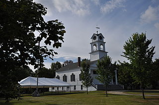
The Paris Hill Historic District encompasses the historic 19th century village of Paris Hill in Paris, Maine. This village was the primary civic seat in the town, which is also the county seat of Oxford County, and was where county facilities were located until they were moved to South Paris in 1895. The district includes a collection of well-preserved residential, civic, and religious structures dating roughly from 1800 to 1860, and was listed on the National Register of Historic Places in 1973.

The Main Street Historic District of Fryeburg, Maine, encompasses the growth of the town's principal village between about 1800 and 1935. It extends along Main Street, from Woodland Street in the north to Portland Street (SR 5 and Maine State Route 113) in the south, and includes forty primary buildings on 55 acres (22 ha). The district was listed on the National Register of Historic Places in 1991.

The Norway Historic District encompasses most of the historic village center of Norway, Maine, and is reflective of the town's growth over 150 years. Although significant early-to-mid 19th century buildings survive in the village, it was significantly damaged by a major fire in 1894, resulting in the construction of a number of new brick and wood frame buildings. The district, which is 44 acres (18 ha) in size, includes 64 historically significant residential, civic, social, and commercial buildings, and was listed on the National Register of Historic Places in 1988.

The Calais Historic District encompasses a city block of 19th-century commercial buildings in the center of Calais, Maine. The district, developed after a fire devastated the area in 1870, contains a cohesive concentration of brick Italianate architecture. The district was listed on the National Register of Historic Places in 1978.
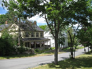
The Calais Residential Historic District encompasses the town's best collection of well-preserved 19th-century residences in Calais, Maine. Located on Calais Street and Main Street, the district includes twenty properties developed between the early 19th century and 1900. It was listed on the National Register of Historic Places in 1994.

The Orono Main Street Historic District encompasses a well-preserved collection of predominantly residential 19th century buildings in Orono, Maine. It extends along Main Street's west side between Maplewood Avenue and Goodridge Road, and on the east side between Spencer and Pine Streets. The area was part of Orono's early settlement, and of a period of rapid growth in the first half of the 19th century. The district was listed on the National Register of Historic Places in 1977.

The Searsport Historic District encompasses a collection of well-preserved mid-to-late 19th-century commercial buildings in the center of Searsport, Maine. They represent the community's peak period of prosperity, when it was a leading shipping and shipbuilding center. The district was listed on the National Register of Historic Places in 1979.

The Winterport Historic District encompasses a significant portion of the town center of Winterport, Maine. The town was mainly developed in the mid-19th century, when it served as the main winter port for Bangor, and features a high concentration of Greek Revival and Italianate architecture. It was listed on the National Register of Historic Places in 1975.

The Camden Great Fire Historic District encompasses a significant portion of the central business district of the town of Camden, Maine, United States. Extending from the Camden Opera House north nearly to Atlantic Avenue, the area's buildings were almost all built in 1893, following a large fire in November 1892 that swept through the area. The district was listed on the National Register of Historic Places in 2007.

The Chestnut Street Historic District encompasses a predominantly residential part of Camden, Maine, United States, which represents a cross-section of the town's architectural history, and of its transition from a shipping center to a summer resort community. The district extends south from the town common, along Chestnut Street, and then east to Dillingham Point. It was listed on the National Register of Historic Places in 1991.

The High Street Historic District encompasses a well-preserved 19th-century residential area of Camden, Maine. Extending along High Street, the district has maintained its character since the 1920s, despite encroaching commercialization of nearby areas, and retains a cross-section of architecture of the 19th and early 20th centuries. It was listed on the National Register of Historic Places in 1989, and enlarged in 1999 to include the Olmsted Brothers-designed Harbor Park at Main and Atlantic.
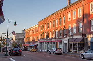
The Main Street Historic District encompasses the historic commercial heart of Rockland, Maine. Located on several blocks of Main Street, the district has a well-preserved collection of commercial architecture dating from the mid-19th to early 20th centuries, the period of the city's height as a shipbuilding and industrial lime processing center. The district was listed on the National Register of Historic Places in 1978, and enlarged in 2012.

The Richmond Historic District encompasses the historic village center of Richmond, Maine. Established in the 17th century, the town reached its height of prosperity in the 19th century as a major shipbuilding center on the Kennebec River. The district was listed on the National Register of Historic Places in 1973.

The Rockland Residential Historic District encompasses a predominantly residential area west of the downtown of Rockland, Maine. With a history dating to the early 18th century, this area includes high quality examples of residential architecture, most dating to the period 1870-1920, and including several fine examples of municipal architecture. It was listed on the National Register of Historic Places in 1987.

The Rockport Historic Kiln Area encompasses a portion of Rockport Marine Park in Rockport, Maine. This area is part of the region's nationally significant lime processing history, including seven historic early 19th-century lime kilns. The area was listed on the National Register of Historic Places in 1970.

The Thomaston Historic District encompasses much of the historic town center of Thomaston, Maine. With a settlement history dating to the 17th century, the town is now a showcase of 19th-century architectural styles up to the 1870s. The district extends for about 2 miles (3.2 km) along United States Route 1, and was listed on the National Register of Historic Places in 1974.

The Plainfield Village Historic District encompasses a significant portion of the village of Plainfield, Vermont. Located in northernmost Plainfield on United States Route 2, the village grew in the 19th century as a mill town and service community for the surround agricultural areas, and has a well-preserved collection of Greek Revival and Italianate architecture. It was listed on the National Register of Historic Places in 1983.


