
Riverside is a neighborhood in the city of East Providence in the U.S. state of Rhode Island. Despite not being an incorporated city, Riverside has its own zip code, 02915, and is an acceptable mailing address according to the United States Postal Service. Riverside has a population of approximately 20,000 people.

This is a list of properties and districts listed on the National Register of Historic Places in Rhode Island. As of May 29, 2015, there are more than 750 listed sites in Rhode Island. All 5 of the counties in Rhode Island have listings on the National Register.

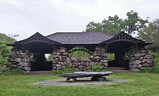
Roger Williams Park is an elaborately landscaped 427-acre (173 ha) city park in Providence, Rhode Island and a historic district listed on the National Register of Historic Places. It is named after Roger Williams, the founder of the city of Providence and the primary founder of the state of Rhode Island.

The Bicknell–Armington Lightning Splitter House is a historic house at 3591 Pawtucket Avenue in East Providence, Rhode Island. The house is of a distinctive type, a "Lightning Splitter", of which only a few instances exist in the Providence area. It is a wood-frame structure with a steep two-story gable roof. Records suggest that the house was constructed about 1827, but architectural evidence suggests it was extensively altered in the 1850s. The main entrance and the interior has a simplified Greek Revival styling. The house was listed on the National Register of Historic Places on November 28, 1980.

The Edgewood Historic District–Taft Estate Plat is a historic district in Cranston, Rhode Island that is bounded by Windsor Road, Narragansett Bay, Circuit Drive and Broad Street. The district represents the final subdivision of a country estate amassed by industrialist Orray Taft (1793-1865). It was laid out in 1904 and most of its residential stock was built between 1905 and 1930. The average size of the lots was 5400 square feet, although there was some variance in size, and a one-acre plot was reserved for the Taft mansion. The houses are architecturally heterogeneous, reflecting all of the major styles of the period; some properties were designed by Norman Isham.

The Norwood Avenue Historic District is a residential historic district in Cranston and Providence, Rhode Island. It includes all of the properties along Norwood Avenue between Broad Street in Cranston and Green Boulevard in Providence. It is lined with houses built mostly between 1890 and 1930 in the Queen Anne and Colonial Revival styles.

The Blackstone Boulevard Realty Plat Historic District is a historic district roughly bounded by Blackstone Blvd., Rochambeau Ave., Holly St. and Elmgrove Ave. in Providence, Rhode Island.
Blackstone Park Historic District is roughly bounded by the Seekonk River, Laurell Avenue, Blackstone Boulevard, and South Angell Street in Providence, Rhode Island within the Blackstone region of the East Side.

The Freeman Plat Historic District is a residential historic district on the East Side of Providence, Rhode Island. The district is a well-preserved example of an early-20th-century planned residential area, encompassing some 50 acres (20 ha). It is roughly bounded by Sessions Street, Morris Avenue, Laurel Avenue, and Wayland Avenue, and consists of a network of generously-landscaped winding roads, laid out in consultation with the Olmsted Brothers design firm. The houses built are generally of high quality, many of them architect-designed, with architecturally diverse revival styles popular at the time. The area was developed between 1916 and 1929 by John Freeman, who owned a country estate in the area, and sought a way to develop the largely swampy tract.
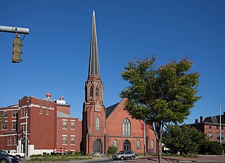
Grace Church is an historic Episcopal church at 300 Westminster Street at Mathewson Street in downtown Providence, Rhode Island. It was built in 1845-46 and was designed by Richard Upjohn in the Gothic Revival style.

Olney Street–Alumni Avenue Historic District is a residential historic district in northeastern Providence, Rhode Island. Located just north of the Moses Brown School campus, this is an enclave of 53 tasteful yet conservative houses built between about 1880 and 1938. It includes houses along Olney Street and Alumni Avenue between Hope and Arlington Streets, and includes a few houses on adjacent streets. Most of these houses are uniformly set back from the street, even though there was no zoning requiring that at the time, and are of brick and/or wood construction. They are stylistically heterogeneous, with Queen Anne and the Colonial Revival predominating.
The Stimson Avenue Historic District is a residential historic district on the east side of Providence, Rhode Island. It includes all of Stimson Avenue and Diman Place, as well as adjacent properties on Angell Street on the south and Hope Street on the west, forming a relatively compact rectangular area. This area was developed roughly between 1880 and 1900, and features a collection of high-quality Queen Anne and Colonial Revival houses, with a few earlier Italianate houses at its edges. Among the finest is 19 Stimson Avenue, built in 1890 to a design by Stone, Carpenter & Willson; it is stylistically transitional between Queen Anne and Colonial Revival, featuring elaborate woodwork and a large number of exterior surface finishes, in a predominantly symmetrical Colonial Revival form. The only non-residential structure is the 1893 brick Central Congregational Church at 296 Angell Street.
The Trinity Square Historic District is a historic district in the Elmwood neighborhood of Providence, Rhode Island. It includes four properties on the south and west side of Trinity Square, the triangular junction of Elmwood Avenue and Broad Street. The visual focal points of the district are the Grace Church Cemetery, which is located south of the square, and the Trinity United Methodist Church, an imposing Gothic Revival structure built in the mid-1860s to a design by Clifton A. Hall. North of the church stands the Clifton Hall Duplex, designed and occupied by Hall, and the James Potter House, an elaborate Queen Anne mansion built c. 1889 and designed by Stone, Carpenter & Willson.

The Wayland Historic District is a predominantly residential historic district on the east side of Providence, Rhode Island. It is a large area, covering about 122 acres (49 ha), bounded roughly on the north by Everett and Laurel Avenues, on the east by Blackstone Boulevard and Butler Avenue, on the west by Arlington Avenue, and on the south by Angell and South Angell Streets. This area, which was in the 19th century part of the Moses Brown farm, was platted for development in 1891, with most of the construction taking place in the early decades of the 20th century. Most of the residential properties in the district are single-family houses, typically built in revival styles popular at the time. They are set on similarly-sized lots with fairly uniform setbacks, and were typically built without garages. There are a number of two-family houses, and a small number of apartment buildings, most of which are found on the arterial roads of the area. There are several religious buildings, including several churches; the most architecturally distinctive religious building is the Jewish Temple Beth El, built 1951–54.

The Blackstone Boulevard–Cole Avenue–Grotto Avenue Historic District is a predominantly residential historic district roughly bounded by Blackstone Boulevard, Cole Avenue, Grotto Avenue, President and Rochambeau Avenues on the east side of Providence, Rhode Island. It encompasses one of the last areas of the city be developed residentially. Covering about 100 acres (40 ha), most of its building stock was built between about 1889 and the 1940s, with a notable building spurt taking place in the 1920s. The architecture in the area is heterogeneous, with Colonial and Georgian Revival styles predominating. The area was developed after the city built Blackstone Boulevard with the intention of developing the area into a streetcar suburb.

The Edgewood Historic District–Shaw Plat is a residential historic district in the Edgewood neighborhood of northeastern Cranston, Rhode Island. It is bounded by Broad Street on the west, Marion Avenue on the south, and Narragansett Bay on the east; it consists of the properties that line the parallel streets, Shaw and Marion Avenues, and the short section of Narragansett Boulevard that runs between Shaw and Marion Avenues. On the north, it abuts the separately-listed Edgewood Historic District–Arnold Farm Plat. The area was platted out between 1867 and 1895, with the construction of most of its housing taking place between 1867 and the start of World War II, with the most construction going on between 1895 and 1930. The district also includes the previously listed Edgewood Yacht Club. In 1853, the 25 acres of land that became the Shaw Plat was sold to Allen Shaw of Providence for $3,660.

The Edgewood Historic District–Arnold Farm Plat is a residential historic district in the Edgewood neighborhood of eastern Cranston, Rhode Island. It is bounded on the north by Albert Avenue, on the east by Narragansett Bay, on the south by Columbia Avenue, and on the west by Broad Street. The district was primarily built out as a streetcar suburb of Providence between 1890 and 1930, and feature styles from Queen Anne and Colonial Revival to Dutch Colonials and two- and three-decker multiunit houses. Prior to its development, the area had been farmed by several generations of the Arnold family.

The Edgewood Historic District–Anstis Greene Estate Plat is a residential historic district in the Edgewood neighborhood of eastern Cranston, Rhode Island. The 34-acre (14 ha) area is bounded on the west by Broad Street, the east by Narragansett Bay, the south by Rosewood Avenue, and on the north by Marion Avenue, where it abuts the Edgewood Historic District-Shaw Plat. The area, originally part of a much larger property belonging to Zachariah Rhodes in the 17th century, was platted for residential development in the decades following the arrival of the streetcar on Broad Street, providing commuter service to Providence. The land was willed by Anstis Rhodes Greene to a group of heirs, who progressively developed their individual portions. The only significant surviving elements that predate this development are two small family cemeteries.

The Elm Tree Plat Historic District encompasses an early 20th-century neighborhood of East Providence, Rhode Island. Developed beginning in 1924, it contains 53 single-family residences and one commercial building, most of which were built between 1925 and 1935 as a streetcar suburb development serving the Providence area. Most of the houses were built by a single pair of developers, Severin Carlson and Carl Johnson, and are one and two-story Bungalow-style houses. It is roughly bounded by Willett, Harvey, and Fenner Avenues and Charlotte Street, in southern East Providence.
The Edgewood Historic District–Sally Greene Homestead Plats is a residential historic district in the Edgewood neighborhood of eastern Cranston, Rhode Island. Bounded by Glen Avenue to the north, Broad Street to the west, Massasoit Street to the south, and the Providence River to the east, this area was developed between 1900 and 1963 as a streetcar suburb for middle and lower middle class residents on what was once a country estate. The district was listed on the National Register of Historic Places in 2016.


