Udagamandalam, and abbreviated as Udhagai or Ooty, (listen is a town and a municipality in the Indian State of Tamil Nadu. It is located 86 km north of Coimbatore and 128 km south of Mysore and is the capital of the Nilgiris district. It is a popular hill station located in the Nilgiri Hills.

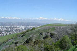
The Puente Hills is a chain of hills, one of the lower Transverse Ranges, in an unincorporated area in eastern Los Angeles County, California, USA. The western end of the range is often referred to locally as the Whittier Hills.

The National Triangle, which is referred to as the Parliamentary Triangle, is the ceremonial precinct of Canberra, containing some of Australia's most significant buildings. The National Triangle is formed by Commonwealth, Kings and Constitution Avenues. Buildings within the National Triangle have been located and designed intentionally for visual effect, and those of national significance are popular tourist attractions.

Ocotillo Wells is an unincorporated community in San Diego County, California. It is 3 miles (4.8 km) west of the Imperial County line on State Route 78 at an elevation of 163 feet (50 m). The name became official in 1962 when it was adopted for federal use by the Board on Geographic Names. A federally recognized variant name, Ocotillo, can cause confusion. The community of Ocotillo, in Imperial County, is only 29 miles (47 km) to the southeast.

Alander Mountain, 2,239 feet (682 m) is a prominent peak of the south Taconic Mountains; it is located in southwest Massachusetts and adjacent New York. Part of the summit is grassy and open and part is covered with scrub oak and shrubs; the sides of the mountain are wooded with northern hardwood tree species. Views from the top include the southern Taconic Mountains, the Hudson River Valley including the Catskills. Several trails traverse Alander Mountain, most notably the 15.7 mi (25.3 km) South Taconic Trail, which passes just beneath the summit.
The Watchung Outliers include six areas of isolated low hills and rock outcrops of volcanic and sedimentary origin in the U.S. states of New York, New Jersey, and Pennsylvania. These geologic outliers are primarily diminutive and detached remnants of the Triassic/Jurassic age Watchung Mountain basalt flows with intervening layers of sedimentary rock. All six of the outliers are found along the western edge of the Newark Basin, occupying small synclines adjacent to the Ramapo fault system. The outliers, from north to south, are known as: Ladentown, Union Hill, New Germantown/Oldwick, Prospect Hill, Sand Brook, and Jacksonwald.

The Washington Confederate Cemetery is a Confederate Cemetery in Hagerstown, Maryland. Its burials include Confederate dead from such nearby battles as Antietam, Gettysburg, Monocacy and South Mountain. Less than 20 percent of its burials are identified. It was established in 1871 as a section of the Rose Hill Cemetery (Maryland).

Horta de Sant Joan is a village in the Terra Alta of Catalonia, Spain.

The New River Mountains are a small 14-mi (23 km) long, mountain range in central Arizona, and on the north border of the Phoenix valley; the range is located on the southwest perimeter of the Arizona transition zone. The range is a sub-part of landforms extending south from the Black Hills of Yavapai County. Rivers and canyons border east and west; the south of the range is located in Maricopa County, the location of much of the Phoenix metropolitan area.

Sapiranga is a city in Brazil in the state of Rio Grande do Sul with a population of roughly 80,000 inhabitants. It is located in an industrial area called "Vale dos Sinos", by the Rio dos Sinos. The town's economy relies heavily on the shoe industry. Other industries are present, but mostly linked to the shoe manufacturing process, such as metallurgic plants in which machinery is built to later be employed in the production of shoes.

Rožnik is a hill in the Rožnik District and Šiška District northwest of the Ljubljana city center. Together with Tivoli City Park, it forms Tivoli–Rožnik Hill–Šiška Hill Landscape Park. Extending from Tivoli Park, it is a popular hiking, running, and excursion destination for residents of Ljubljana.

Waggy was an unincorporated community on the border of Braxton County and Nicholas County, West Virginia, located just west of the Webster County line on the road from Bays to Erbacon and a logging railroad from Ramp Run. It was also known as Rose Hill.

The Bear Lodge Mountains are a small mountain range in Crook County, Wyoming. These mountains are protected in the Black Hills National Forest as part of its Bearlodge District. Devils Tower National Monument was the first U.S. National Monument and draws about 400,000 visitors per year to the area. The Bear Lodge Mountains are one of three mountain ranges that comprise the Black Hills region and national forest, including the Black Hills itself and South Dakota's Elk Mountains.

Gross Hill is a mountain in the Central New York Region of New York. It is located northwest of Garrattsville, New York. Crystal Lake is located south and Wooley Hill is located northeast of Gross Hill.

Fox Hill is a mountain located in Adirondack Mountains of New York located in the Town of Indian Lake east of Indian Lake.

Wilders Hill is a mountain located in Central New York Region of New York east of Richfield Springs, New York. Waiontha Mountain is located southeast of Wilders Hill.

Red Hill is a mountain located in the Catskill Mountains of New York east-south of Frost Valley. Woodhull Mountain is located northeast of Red Hill.

Van Loan Hill is a mountain in Greene County, New York. It is located in the Catskill Mountains southwest of Maplecrest. Round Hill is located west, Elm Ridge is located north-northeast, and East Jewett Range is located south of Van Loan Hill.


