
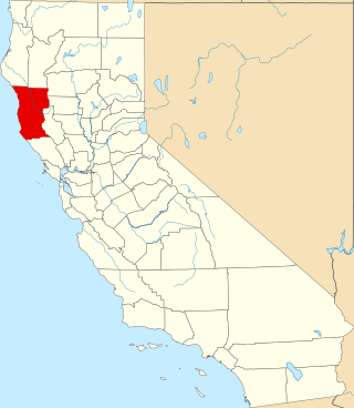
Mendocino County is a county located on the North Coast of the U.S. state of California. As of the 2020 census, the population was 91,601. The county seat is Ukiah.
The Yuki are an indigenous people of California who were traditionally divided into three groups: Ukomno'om, Huchnom, and Ukohtontilka or Ukosontilka. The territory of these three groups included Round Valley and much of northern Mendocino County and Lake County. Today they are enrolled members of the Round Valley Indian Tribes of the Round Valley Reservation. The exonym "Yuki" may derive from the Wintu word meaning "foreigner" or "enemy."
The Mariposa War, also known as the Yosemite Indian War, was a conflict between the United States and the indigenous people of California's Sierra Nevada in the 1850s. The war was fought primarily in Mariposa County and surrounding areas, and was sparked by the discovery of gold in the region. As a result of the military expedition, the Mariposa Battalion became the first non-indigenous group to enter Yosemite Valley and the Nelder Grove.
The Mendocino War was a conflict between the Yuki and white settlers in Mendocino County, California between July 1859 and January 18, 1860. It was caused by settler intrusion and slave raids on native lands and subsequent native retaliation, resulting in the deaths of hundreds of Yuki.

The Round Valley Indian Reservation is a federally recognized Indian reservation lying primarily in northern Mendocino County, California, United States. A small part of it extends northward into southern Trinity County. The total land area, including off-reservation trust land, is 93.939 km2. More than two-thirds of this area is off-reservation trust land, including about 405 acres (1.64 km2) in the community of Covelo. The total resident population as of the 2000 census was 300 persons, of whom 99 lived in Covelo.
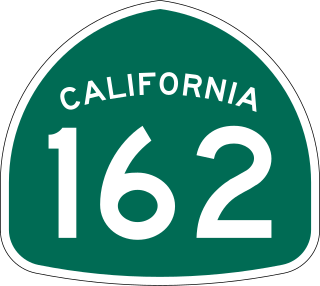
State Route 162 is a state highway in the U.S. state of California that runs roughly west–east through the Coast Ranges and the Sacramento Valley to the western slopes of the Sierra Nevada. It begins at U.S. Route 101 near Longvale, in Mendocino County, and ends at Brush Creek, in Butte County. For most of its length, it is a two lane, undivided highway. SR 162 is not signed as a contiguous route through Mendocino National Forest in Mendocino and Glenn counties. Instead, the portion inside the national forest is federally maintained by the U.S. Forest Service as Forest Highway 7 (FH 7), and is not included in the state route logs.
The 70-acre (280,000 m2) Coyote Valley Reservation in Redwood Valley, California is home to about 170 members of the Coyote Valley tribe of the Native American Pomo people, who descend from the Shodakai Pomo. They are a federally recognized tribe, who were formerly known as the Coyote Valley Band of Pomo Indians of California.
The Redwood Valley Rancheria is a federally recognized Indian tribe located in Redwood Valley, Mendocino County, California. The tribe is primarily composed of Pomo Indians. Redwood Valley Rancheria is a sovereign Indian tribe with the powers of self-governance.
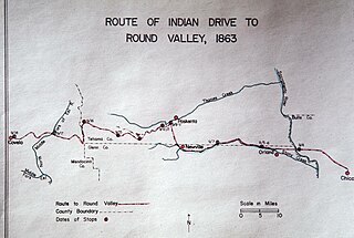
The Nome Cult Trail is a northern Californian historic trail located in present-day Mendocino National Forest which goes along Round Valley Road and through Rocky Ridge and the Sacramento Valley. It is also known as the Konkow Trail of Tears. On August 28, 1863, all Konkow Maidu were to be at the Bidwell Ranch in Chico to be taken to the Round Valley Reservation at Covelo in Mendocino County. Any Native Americans remaining in the area were to be shot. 435 Maidu were rounded up and marched under guard west out of the Sacramento Valley and through to the Coastal Range. 461 Native Americans started the trek, 277 finished. They reached Round Valley on September 18, 1863.
The Sherwood Valley Rancheria of Pomo Indians of California is a federally recognized tribe of Pomo Indians in California.

The Sebastian Indian Reservation (1853-1864), more commonly known as the Tejon Indian Reservation, was formerly at the southwestern corner of the San Joaquin Valley in the Tehachapi Mountains, in southern central California.
Visalia, California, commonly known in the 1850s as Four Creeks, is the oldest continuously inhabited inland European settlement between Stockton and Los Angeles. The city played an important role in the American colonization of the San Joaquin Valley as the county seat of Old Tulare County, an expansive region comprising most if not all of modern-day Fresno, Kings, and Kern counties.

Bald Hills War (1858–1864) was a war fought by the forces of the California Militia, California Volunteers and soldiers of the U.S. Army against the Chilula, Lassik, Hupa, Mattole, Nongatl, Sinkyone, Tsnungwe, Wailaki, Whilkut and Wiyot Native American peoples.

Mendocino Indian Reservation, a former Indian reservation in Mendocino County, one of the early Indian reservations to be established in California by the federal government for the resettlement of California Indians. It was established in the spring of 1856, in the vicinity of modern Noyo. Its area was 25,000 acres and its boundary extended north from what is now Simpson Lane at 39°24′43″N123°48′30″W to Abalobadiah Creek and east from the Pacific Ocean to a north–south line passing through the summit of Bald Hill.
The Round Valley War was an 1887 conflict between American Colonists and Yuki Indians on the Round Valley Indian Tribes of the Round Valley Reservation in California. The conflict started as colonists were beginning to encroach on reservation lands, making the already difficult circumstances for the Yuki people who had been placed there following the Mendocino War even more unfavourable. The Federal Office of Indian Affairs moved to have the trespassing settlers evicted. The settlers turned to local authorities and the Sheriff of Mendocino arrested the federal officer who had filed the accusations against the settlers.
The California Indian Wars were a series of wars, battles, and massacres between the United States Army, and the Indigenous peoples of California. The wars lasted from 1850, immediately after Alta California, acquired during the Mexican–American War, became the state of California, to 1880 when the last minor military operation on the Colorado River ended the Calloway Affair of 1880.
The Asbill massacre refers to the murder of 40 Yuki people in Round Valley in 1854 by a band of six White explorers from Missouri.
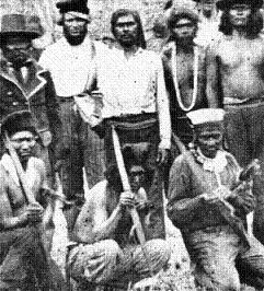
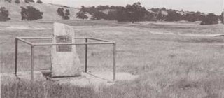
The Round Valley Settler Massacres of 1856–1859 were a series of massacres committed by early white settlers of California with cooperation and funding from the government of California and the support of prominent Californians against the Yuki people of Round Valley, Mendocino County, California. More than 1,000 Yuki are estimated to have been killed; many others were enslaved and only 300 survived. The intent of the massacres was to exterminate the Yuki and gain control of the land they inhabited. U.S. Army soldiers deployed to the valley stopped most of the killings and in 1862 the California legislature revoked a law which permitted the kidnapping and enslavement of Native Americans in the state.
Walter S. Jarboe was an American soldier and perpetrator of massacres against the Yuki people during the California genocide.
Nomi Lackee Indian Reservation is historical site built in 1854 in Flournoy, California in Tehama County, California. The site of the Nomi Lackee Indian Reservation is a California Historical Landmark No. 357 listed on October 9, 1939. Nomi Lackee Indian Reservation was Native American reservation from 1854 to 1866. The reservation was also used as United States Army military fort with a population of 300 to 2,500. The Nomi Lackee Indian Reservation was 25,139 acres, in what is now Tehama County on Osborn Road. In 1866 the population moved to the Round Valley Reservation in Mendocino County, California and Trinity County, California. Round Valley, Mendocino County, California is a California Historical Landmark]] No. 674.


